Mist Trail

| Length | 7 miles out and back |
| Location | Yosemite National Park |
| Elevation Gain | |
| Vernal Falls | 1100 ft |
| Nevada Falls | 2230 ft |
| Hiking details | |
| Trail Difficulty | Moderate to Strenuous |
| Season | Spring to Fall |
The Mist Trail is one of the most popular short hikes in Yosemite National Park, California, USA. The hike follows the Merced River, starting at Happy Isles in Yosemite Valley, past Vernal Fall and Emerald Pool, to Nevada Fall.
Description
Along the trail, the Merced River is a tumultuous mountain stream, lying in a U-shaped valley. Enormous boulders, some the size of a house, are dwarfed by the sheer faces of exfoliating granite, which rise 3000 feet (914 m) from the river. Through it all, the Merced River rushes down from its source in the High Sierra, and broadens on the floor of Yosemite Valley.
A trail which links to the John Muir Trail starts after crossing from the Happy Isles. Depending on one's conditioning, a bridge which re-crosses the river – the halfway point of a hike to the foot of Vernal Fall – can be reached in 15 to 30 minutes.
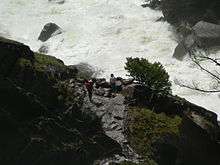
To the side of Vernal Fall, the mist from the river blankets the trail, which was improved during the WPA projects of the 1930s. Here is where raingear becomes handy: in the spring, hikers often become completely drenched from water sprayed off Vernal Fall. This is one of the few places where a complete circular rainbow can be viewed. The trail now crosses a sheer face which is made somewhat easier by a single guard rail. At the top of Vernal Fall, the Merced River traverses a shelf of granite, and the hikers frequently sun themselves to dry off.
The Emerald Pool is named for the color of the river here.
Up the trail, Nevada Fall, a waterfall that is almost twice the height of Vernal Fall, awaits the hiker, although there is no cascade of mist over the trail at that waterfall. Behind Nevada Fall is Liberty Cap, an impressive lump of granite. The Mist Trail then rejoins the John Muir Trail: the hiker can travel in Little Yosemite Valley, or take a side trip to the top of Half Dome, using cables to climb the rock. Permits must be obtained in advance to hike Half Dome, and back country permits are required to stay overnight along the John Muir Trail.
The distance from Happy Isles trailhead to the top of Nevada Falls is 3.5 miles (5.6 km) one way with an elevation gain of 2230 ft.
Related hikes
- The High Sierra Camps provide a loop through the Yosemite backcountry, with tent cabins spaced one day's hike apart.
- A panoramic view of the Mist Trail can be had from Glacier Point, 3000 feet (900 m) above, looking north. During the summer, shuttle buses from the floor of the valley will take an hour to arrive at Glacier Point.
- The John Muir Trail starts at the same trailhead as the Mist Trail.
Notes
Coordinates: 37°43′37″N 119°32′40″W / 37.72694°N 119.54444°W
External links
| Wikimedia Commons has media related to Mist Trail. |
| Attractions |
| |||||||
|---|---|---|---|---|---|---|---|---|
| People | ||||||||
| Lodging & camping | ||||||||
| Natural disasters | ||||||||
| Transportation | ||||||||
| Nearby municipalities | ||||||||
| Additional information |
| |||||||
