Mitkof Island
Mitkof Island is an island in the Alexander Archipelago in southeast Alaska, at 56°35′54″N 132°48′33″W / 56.59833°N 132.80917°W. between Kupreanof Island to the west and the Alaska mainland to the east. It is about 16 km (9.9 mi) wide and 28 km (17 mi) long with a land area of 539.7 km2 (208.4 sq mi), making it the 30th largest island in the United States. Much of the island is managed as part of the Tongass National Forest.
The island is relatively flat with numerous muskegs. The highest point is Crystal Mountain 3,317 ft (1,011 m).
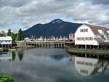
The city of Petersburg is on the north end of the island. The total population of the island was 3,364 at the 2000 census, almost all of it in the city of Petersburg.
The Wrangell Narrows,[1] one of the six Listed Narrows of Southeast Alaska, runs from the south to the north end of Mitkof Island. Bordered by Mitkof Island on one side, and Kuprenof and Woewodski Islands on the other, the Wrangell Narrows creates the only navigable 'Inside Passage' at this latitude. Because of its shallow depths, the largest cruise ships do not pass through these narrows. Spirit Creek is the southern most stream on the island in the Wrangell Narrows, just two miles from where the narrows opens onto Sumner Strait.[2]
The first European to sight the island was James Johnstone, one of George Vancouver's officers during his 1791-95 expedition, in 1793.[3] The island is shown as separate from Kupreanof Island in an 1844 Russian chart, while the name was published in 1848 on a Russian Hydrographic Department chart as "Os(trov) Mitkova" for an Admiral Prokofy Mitkov.[4][5]
References
- ↑ Wrangell Narrows
- ↑ http://geonames.usgs.gov/pls/gnispublic/f?p=154:2:7675718828358284::NO:RP::
- ↑ Vancouver, George, and John Vancouver (1801). A voyage of discovery to the North Pacific ocean, and round the world. London: J. Stockdale.
- ↑ U.S. Geological Survey Geographic Names Information System: Mitkof Island
- ↑ Владимирский след на мировой карте/Vladimir's Mark on the World Map
- Wrangell Narrows Wrangell Narrows
- Mitkof Island: Census Tract 2, Wrangell-Petersburg Census Area, Alaska United States Census Bureau