Mobayi-Mbongo
| Mobayi-Mbongo | |
|---|---|
 Mobayi-Mbongo | |
| Coordinates: CD 4°18′00″N 21°10′48″E / 4.300°N 21.180°ECoordinates: CD 4°18′00″N 21°10′48″E / 4.300°N 21.180°E | |
| Country | Democratic Republic of the Congo |
| Province | Nord-Ubangi |
| Territory | Mobayi-Mbongo Territory |
| Population (2012) | |
| • Total | 5,640 |
| National language | Lingala |
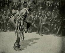
The best dancer on the Ubangi at Banzyville, 1906

Bananas being brought by children into Banzyville, 1906
Mobayi-Mbongo, formerly known as Banzyville or Banzystad, is a town in Nord-Ubangi Province, in the northwestern part of the Democratic Republic of the Congo, on the Ubangi River. It lies opposite the Central African town of Mobaye.[1] As of 2012 the estimated population was 5,640.[2]
A small hydroelectric power station was opened in 1989, with some of the power being exported to the CAR.[3]
References
- ↑ Blaes, X. (October 2008). "Découpage administratif de la République Démocratique du Congo" (PDF). PNUD-SIG. Archived from the original (PDF) on 2012-08-14. Retrieved 2011-12-09.
- ↑ "Mobayi-Mbongo". World Gazetteer. Archived from the original on 2013-02-09. Retrieved 2012-01-31.
- ↑ Europa Publications Limited (2002). Africa South of the Sahara 2003. Routledge. ISBN 1-85743-131-6.
This article is issued from Wikipedia - version of the 6/23/2016. The text is available under the Creative Commons Attribution/Share Alike but additional terms may apply for the media files.