Moera
| Moera | |
|---|---|
| Basic information | |
| Local authority | Lower Hutt City |
| Date established | 1920s |
| Population | 1,611 (2006 [1]) |
| Surrounds | |
| North | Woburn |
| Northeast | Waiwhetū |
| East | Gracefield |
| South | Seaview |
| West | Petone |
| Northwest | Ava |
Moera is a suburb of the city of Lower Hutt in New Zealand and urban district of the city of Wellington.
Location
Located at the south-eastern end of the Hutt River, the suburb's name Moera is thought to be a simplification of Moe-i-te-ra, meaning "sleeping in the sun".

History
Prior to European settlement, the Moera area was part of a large tidal estuary at the mouth of the Awamutu and Waiwhetū Streams. The southern side of Waiwhetū Stream contained a number of Ngati Ira villages.
In 1843 William Trotter settled in the area and established a fruit garden and nursery. The 1855 Wairarapa earthquake raised the Hutt Valley from 1 to 2 metres, thus draining the swampy estuary.
The area remained farmland up until 1926 when the Petone Railway Workshops were moved to Moera and Government sponsored prefabricated workers housing, built by the Railways Department, were sold to families.[2]
Influence
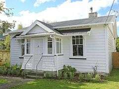
To house the workers almost 600 kitset homes were built to a simple 5 room layout. The whole project was completed by May 1927. These provided a template for State housing developments in later years.
Many of the current houses are original Railways Department built prefabricated cottages dating from that era.
Features
Moera was home to the Hutt Park Raceway from the 1860s, [3] until Harness and Greyhound racing ceased at the park in 2003, [4] The 12 Hectare park area has since been established as a sports and recreation ground, including a 7 court indoor sports centre and indoor children's playground. [5]
The park lies between the southern industrial area of Lower Hutt and the residential suburb of Moera and is bounded by the Waiwhetu Stream, Gracefield railway line and Randwick Road.
A number of neighbouring facilities, sites and properties are complementary to the park. These include private commercial properties between Seaview Road and the Waiwhetu Stream, the Seaview Urupa, and walkways that link to the Hutt River and Waiwhetu Stream. [6]
References
- ↑ Hutt City Council - 2006 Hutt City Demographic Profile Retrieved: 7 January 2009
- ↑ Johnston, Warwick (2001). Moera Sleeping in the Sun. Lower Hutt: Hutt City Libraries. pp. 13–15.
- ↑ Moera, Sleeping In the sun, Warwick Johnston (2001)
- ↑ ' ' http://www.nzherald.co.nz/racing/news/article.cfm?c_id=53&objectid=3509834.'
- ↑ http://www.stuff.co.nz/dominion-post/news/5582582/New-6m-Hutt-Park-stadium-opens
- ↑ http://www.huttcity.govt.nz/Documents/a-z/Hutt%20Park%20management%20plan.pdf)
Coordinates: 41°13′S 174°54′E / 41.217°S 174.900°E