Monnickendam
| Monnickendam | |
|---|---|
| City | |
|
Monnickendam in 2012 | |
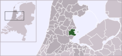 | |
 The town centre (dark green) and the statistical district (light green) of Monnickendam in the municipality of Waterland | |
| Coordinates: 52°28′N 5°2′E / 52.467°N 5.033°ECoordinates: 52°28′N 5°2′E / 52.467°N 5.033°E | |
| Country | Netherlands |
| Province | North Holland |
| Municipality | Waterland |
| Area (2012)[1] | |
| • Total | 1,536 ha (3,796 acres) |
| • Land | 1,464 ha (3,618 acres) |
| • Water | 72 ha (178 acres) |
| Population (2012)[1] | |
| • Total | 9,915 |
| • Density | 650/km2 (1,700/sq mi) |
| Postal code | 1140–1141[2] |
| Area code | 0299[3] |

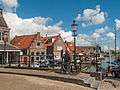
Monnickendam (Dutch pronunciation: [ˌmɔnɪkənˈdɑm]) is a city in the Dutch province of North Holland. It is a part of the municipality of Waterland, and lies on the coast of the IJsselmeer, about 8 km southeast of Purmerend. It received city rights in 1355 and suffered a lot of damage during the fires of 1500 and 1513.
History
Monnikendam was also the name of a number of warships - mainly built at the port of that name - during the Anglo-Dutch Wars.
The town was founded by monks,[4] the name Monnickendam translates as 'Monk's dam'.
Monnickendam was a separate municipality until 1991, when it was merged into Waterland.[5] Although it is a small fishing village today, it was an important port in earlier centuries. It possesses a seventeenth-century weigh house, once used by merchants and port officials, and a bell tower that dates from 1591. The fourteenth century church of St. Nicholas, renovated in 1602, is particularly notable. The synagogue was built in 1894.[6] Jewish families named Monnikendam trace their roots to this town.
The town was the site of an artist's colony in the early twentieth century.
Demographics
In 2001, the town of Monnickendam had 9,546 inhabitants. The built-up area of the town was 1.34 km², and contained 3,766 residences.[7] The wider statistical area of Monnickendam has a population of around 9,680.[8]
Notable residents
- Cornelis Dirkszoon, mayor during the 80-year war.
- Hermann Jung (about 1608–1678) famous Lutheran theologian and preacher in Monnickendam. Born probably at Brokreihe(-Nord) near Hodorf (Holstein) around 1608. Friend of Jan Amos Comenius and a correspondent of Philipp Jakob Spener, Hermann Jung developed himself from a preacher of the small Lutheran community in Monnickendam to an important representative of early Lutheran pietism in the Netherlands.
- Wendelmoet Claesdochter, first female martyr during the reformation. Condemned to death by fire in 1527 in The Hague.
- Simon Lambrechtszoon Mau, captain of the "Duyfken", joining the first expedition to the Dutch Indies, using the route "Om de Zuid", around Africa.
- Marlou van Rhijn, Paralympic 200m sprint world record holder and gold medal winner was born here.
Gallery
 Monk sculpture at the bridge near de Waag
 Church: de Grote of Sint Nicolaaskerk
 Tower (de Speeltoren) and de Waag
 View to the port
 View to a street (het Noordeinde)
See also
References
- 1 2 (Dutch) Kerncijfers wijken en buurten 2009-2012, Statline, Statistics Netherlands, 2014. Retrieved 19 August 2015.
- ↑ (Dutch) Zoekresultaten, Postcode.nl. Retrieved 19 August 2015.
- ↑ (Dutch) Netnummer zoeken, Telefoonboek.nl. Retrieved 19 August 2015.
- ↑ DK Eyewitness Travel Guide: The Netherlands: The Netherlands. DK Publishing. 1 August 2011. p. 174. ISBN 978-0-7566-8476-1.
- ↑ Ad van der Meer and Onno Boonstra, Repertorium van Nederlandse gemeenten, KNAW, 2006.
- ↑ Synagogues of Europe: Architecture, History, Meaning, by Carol Herselle Krinsky - 1996 ,p. 68
- ↑ Statistics Netherlands (CBS), Bevolkingskernen in Nederland 2001 . Statistics are for the continuous built-up area.
- ↑ Statistics Netherlands (CBS), Gemeente Op Maat 2004: Waterland .
External links
| Wikimedia Commons has media related to Monnickendam. |
| Wikivoyage has a travel guide for Monnickendam. |
- J. Kuyper, Gemeente Atlas van Nederland, 1865-1870, "Monnickendam". Map of the former municipality, around 1868.
 Chisholm, Hugh, ed. (1911). "Monnikendam". Encyclopædia Britannica. 18 (11th ed.). Cambridge University Press. p. 629.