Mont Chapman
| Mont Chapman | |
|---|---|
|
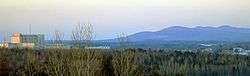
The Stoke Mountains as seen from the Sherbrooke city limits in Fleurimont. | |
| Highest point | |
| Elevation | 658 m (2,159 ft) [1] |
| Prominence | 308 m (1,010 ft) [1] |
| Coordinates | 45°34′29″N 71°40′42″W / 45.57472°N 71.67833°WCoordinates: 45°34′29″N 71°40′42″W / 45.57472°N 71.67833°W [2] |
| Geography | |
| Parent range | Southern Notre Dame Mountains |
| Climbing | |
| Easiest route | hiking via 14e Rang Est in Stoke, QC |

Mont Chapman (elevation 658 metres (2,159 ft)) is the highest peak in the Stoke Mountains of the southern Notre Dame mountain range located in Stoke, Quebec, Canada. It is accessible from trails maintained by Les Sentiers de l'Estrie. From the summit, one is able to see Mont Ham, Mont Ste-Cécile, and Mont Mégantic. Neighboring Bald Peak (elevation approx. 611 metres (2,005 ft),[3] 45°34′17″N 71°40′47″W / 45.57139°N 71.67972°W[4]) is accessible by these same trails.
References
- 1 2 "Mont Chapman, Québec". Peakbagger.com. 1 Nov 2004. Retrieved 9 Apr 2012.
- ↑ Reference number 144779 of the Commission de toponymie du Québec (French)
- ↑ "Pic Bald ouest". Peakbagger.com. Retrieved 6 August 2014.
- ↑ Reference number 148518 of the Commission de toponymie du Québec (French)
External links
This article is issued from Wikipedia - version of the 12/6/2015. The text is available under the Creative Commons Attribution/Share Alike but additional terms may apply for the media files.