Montclair Connection
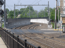

The Montclair Connection is a short section of double-track New Jersey Transit rail in New Jersey, United States, connecting the former end of the Montclair Branch at Bay Street Station to the old Boonton Line southeast of Walnut Street Station.
The connection opened on Monday, September 30, 2002,[1] at a cost of $63 million.[2][3] At the same time, Bay Street Station was rebuilt and Montclair State University station was built. The Montclair and Boonton lines were combined into the Montclair-Boonton Line, and passenger service was ended on the old Boonton Line east of the connection; the line was used by Norfolk Southern for freight, but parts of it have been reclaimed by nature or have fallen into disrepair, especially east of the Passaic River, where DB and WR Drawbridges have been condemned (DB abandoned in the open position). As part of the project, three Boonton Line stations were closed on September 20, 2002; Benson Street, Rowe Street, and Arlington.[4]
The Montclair Connection was built to give passengers on the Boonton Line direct access to New York Penn Station; prior to the change, Boonton Line trains could only go to Hoboken Terminal. The idea for the connection was first proposed in 1929 when the Regional Plan Association proposed linking the Delaware, Lackawanna & Western Railroad's Montclair Branch with the Erie Railroad's Greenwood Lake Branch, but the plan was abandoned due to the economic difficulties associated with the Great Depression.[5]
The merger between the Erie and Lackawanna Railroads in 1960 speeded up the reconfiguration that was completed in March 1963, when the former Erie Main Line was connected to the Lackawanna’s Boonton Line south of Paterson station to form today’s Main Line. Meanwhile, the Boonton Line west of Mountain View station was linked to the Erie’s Greenwood Lake Branch to form the current Boonton Line.[5]
The reconfiguration again spurred the Montclair Connection idea, but the proposal was not brought back until the late 1980s when New Jersey Transit proposed for a one-track connection that would have accommodated only diesel trains. Later, the plans were revised to include a two-track connection and five miles of overhead catenary wires, allowing for electric train service and increased travel destinations. After negotiations with the Township of Montclair, an agreement was reached in 1998, and construction began in 1999[5]
Map
|
|
To Hackettstown | ||||
|
|
Walnut Street | ||||
|
|
Walnut Street | ||||
|
|
Grove Street | ||||
|
|
Claremont Avenue | ||||
|
|
Pine Street | ||||
|
|
Old route diverges | ||||
|
|
Connecting track | ||||
|
|
Glenridge Avenue, end of new track | ||||
|
|
Bay Street | ||||
|
|
Benson Street | ||||
|
|
Rowe Street | ||||
|
|
Arlington | ||||
|
|
|||||
Problems with the connection
Several problems accompanied the opening of the connection. One concern is that the three closed Boonton Line stations no longer have rail service; the stations and trackage have since fallen into disrepair as the alignment has been reclaimed by nature.
Another issue is that the line is not entirely electrified; catenary currently ends at Montclair State University. Electric service was greatly expanded from Montclair to New York and Hoboken, but diesel service from Montclair westward was decreased. While the majority of trains from Montclair are bound for New York City, most of the trains from places in Morris and Warren counties still go to Hoboken, and there is no direct service to New York past Montclair.
References
- ↑ "New Jersey Transit". www.njtransit.com. Retrieved 2016-05-09.
- ↑ "New Montclair Connection Rail Link Opens Provides direct service to Manhattan and Newark". www.njtransit.com. Retrieved 2016-05-09.
- ↑ Smothers, Ronald (2002-10-01). "N.J. Transit Links Midtown And Montclair". The New York Times. ISSN 0362-4331. Retrieved 2016-05-09.
- ↑ Galant, Debra (2002-09-29). "JERSEY; Montclair's Connection Has Its Price". The New York Times. ISSN 0362-4331. Retrieved 2016-05-09.
- 1 2 3 "Introducing MidTOWN Direct Montclair The Montclair-Boonton Line" (PDF). njtransit.com. New Jersey Transit. September 2002. Retrieved May 9, 2016.
| Hoboken Division | ||
|---|---|---|
| Newark Division | ||
| Connections | ||
| Current rolling stock | ||
| Proposed lines | ||
| Other topics | ||
Coordinates: 40°48′37″N 74°12′26″W / 40.8102°N 74.2073°W