Mooi River (town)
| Mooi River | |
|---|---|
|
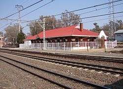
Mooirivier railway station | |
 Mooi River  Mooi River  Mooi River
| |
| Coordinates: 29°12′S 29°59′E / 29.200°S 29.983°ECoordinates: 29°12′S 29°59′E / 29.200°S 29.983°E | |
| Country | South Africa |
| Province | KwaZulu-Natal |
| District | Umgungundlovu |
| Municipality | Mpofana |
| Established | 1852 |
| Area[1] | |
| • Total | 13.76 km2 (5.31 sq mi) |
| Elevation | 1,393 m (4,570 ft) |
| Population (2011)[1] | |
| • Total | 17,779 |
| • Density | 1,300/km2 (3,300/sq mi) |
| Racial makeup (2011)[1] | |
| • Black African | 91.6% |
| • Coloured | 1.0% |
| • Indian/Asian | 3.5% |
| • White | 3.6% |
| • Other | 0.2% |
| First languages (2011)[1] | |
| • Zulu | 82.75% |
| • English | 7.8% |
| • Afrikaans | 0.8% |
| • Sotho | 0.8% |
| • Other | 7.85% |
| PO box | 3300 |
| Area code | 033 |
Mooi River (Afrikaans: Mooirivier) is a small town situated at 1,389 m above sea level and 160 km from the coast in KwaZulu-Natal, South Africa. The first European settlement in the area was at Mooi River Drift in 1852. This was formally named Weston in 1866 after the first Governor of Natal, Martin West.
In 1879, an Irishman named Alexander Lawrence purchased the farm "Grantleigh" upstream from Weston, on the banks of the Mooi River. "Mooirivier" is Afrikaans for "beautiful river".
In 1884, the railway line from Durban, on the coast, to Johannesburg, in the interior, reached the area and was built across Alexander Lawrence's land. He subsequently laid out and establish the village of Lawrenceville on his farm "Grantleigh" and so is known as "The Father of Mooi River". In 1921, the village was renamed Mooi River when it was declared a town.
It lies on the principal road N3 and rail routes between Johannesburg and Durban.[2] Although the railway-station is no longer used for passengers, goods are still carried. There is a toll plaza located on the N3 at Mooi River.
There are six schools serving the Mooi River municipal area with numerous others further from town that serve the traditional farm labourer communities. The six main schools are:
- Treverton Preparatory School and College, a private school of about 600 students. In the hills of the small game park within Treverton there lie some trenches used in the Boer wars. From these the Boers observed English movements at Weston - their remount depot.
- Weston, a public agricultural school with a very good reputation. There is great rugby rivalry between these two schools.
- Mooi River Primary in the centre of town.
- Ai Kajee Primary.
- Bruntville Primary serving the Bruntville area of Mooi River
- Emnyezaneni Secondary school serving the Bruntville area of Mooi River
The urban economy of the area is currently based primarily on Retail entrepreneurship, Tourism and supporting the local agricultural community. Previously, the backbone of the urban economy had been Mooi River Textiles which finally closed in 2002 after years of down-sizing. The decline of the textile industry is being reversed however with large foreign investment from the Far-East.
The rural economy is based on agriculture and tourism. The main farming categories are dairy and equine. Local farmers are supported by the Mooi River Farmers Association
Mooi River forms an important part of the Midlands Meander tourism route
People
- Candice Swanepoel - model best known for her work with Victoria's Secret. In 2012, she came in 10th on the Forbes top-earning models list.
References
- 1 2 3 4 Sum of the Main Places Bruntville, Mooi River and Townview from Census 2011.
- ↑ "Mooi River". Retrieved 2010-03-26.
Municipalities and communities of uMgungundlovu District Municipality, KwaZulu-Natal | ||
|---|---|---|
District seat: Pietermaritzburg | ||
| uMshwathi | .svg.png) | |
| uMngeni | ||
| Mpofana | ||
| Impendle | ||
| Msunduzi | ||
| Mkhambathini | ||
| Richmond | ||