Moorook railway line
| Moorook railway line | ||||||||||||||||||||||||||||||||||||||||||||||||||||||||||||||||||||||||||||||||||||||||||||||||||||||||||||||||||||||
|---|---|---|---|---|---|---|---|---|---|---|---|---|---|---|---|---|---|---|---|---|---|---|---|---|---|---|---|---|---|---|---|---|---|---|---|---|---|---|---|---|---|---|---|---|---|---|---|---|---|---|---|---|---|---|---|---|---|---|---|---|---|---|---|---|---|---|---|---|---|---|---|---|---|---|---|---|---|---|---|---|---|---|---|---|---|---|---|---|---|---|---|---|---|---|---|---|---|---|---|---|---|---|---|---|---|---|---|---|---|---|---|---|---|---|---|---|---|---|
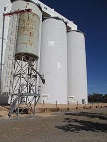 Chute for loading bulk grain into trains at Wunkar (photographed 2015) | ||||||||||||||||||||||||||||||||||||||||||||||||||||||||||||||||||||||||||||||||||||||||||||||||||||||||||||||||||||||
| Overview | ||||||||||||||||||||||||||||||||||||||||||||||||||||||||||||||||||||||||||||||||||||||||||||||||||||||||||||||||||||||
| System | South Australian Railways | |||||||||||||||||||||||||||||||||||||||||||||||||||||||||||||||||||||||||||||||||||||||||||||||||||||||||||||||||||||
| Status | Closed and removed | |||||||||||||||||||||||||||||||||||||||||||||||||||||||||||||||||||||||||||||||||||||||||||||||||||||||||||||||||||||
| Termini |
Wanbi Yinkanie | |||||||||||||||||||||||||||||||||||||||||||||||||||||||||||||||||||||||||||||||||||||||||||||||||||||||||||||||||||||
| Continues from | Barmera line | |||||||||||||||||||||||||||||||||||||||||||||||||||||||||||||||||||||||||||||||||||||||||||||||||||||||||||||||||||||
| Operation | ||||||||||||||||||||||||||||||||||||||||||||||||||||||||||||||||||||||||||||||||||||||||||||||||||||||||||||||||||||||
| Opened | 4 September 1925 | |||||||||||||||||||||||||||||||||||||||||||||||||||||||||||||||||||||||||||||||||||||||||||||||||||||||||||||||||||||
| Closed | 1 May 1971 | |||||||||||||||||||||||||||||||||||||||||||||||||||||||||||||||||||||||||||||||||||||||||||||||||||||||||||||||||||||
| Technical | ||||||||||||||||||||||||||||||||||||||||||||||||||||||||||||||||||||||||||||||||||||||||||||||||||||||||||||||||||||||
| Line length | 49.6 km (30.8 mi) | |||||||||||||||||||||||||||||||||||||||||||||||||||||||||||||||||||||||||||||||||||||||||||||||||||||||||||||||||||||
| Track gauge | 5 ft 3 in (1,600 mm) | |||||||||||||||||||||||||||||||||||||||||||||||||||||||||||||||||||||||||||||||||||||||||||||||||||||||||||||||||||||
| ||||||||||||||||||||||||||||||||||||||||||||||||||||||||||||||||||||||||||||||||||||||||||||||||||||||||||||||||||||||
The Moorook railway line was a 49.6 kilometres (30.8 mi) railway line on the South Australian Railways network. It ran from a junction with the Bamera line at Wanbi north to Yinkanie near Moorook opening on 7 September 1925. It was proposed to later extend the line to Moorook and Kingston On Murray if demand arose,[1] but road transport improved so the railway was never extended, and the line was closed on 1 May 1971.[2]
Route
The route of the line was designed to cover the gap between the Waikerie and Loxton lines at the lowest cost.[1] The names of the new stations were Gluyas, Caliph, Bayah, Tuscan, Koowa, Wunkar, Myrla, Wappalka and Yankanie.[1] (Sources are inconsistent on whether the terminus was spelled Yankanie or Yinkanie.)
References
- 1 2 3 "The Moorook Railway". The Chronicle. Adelaide: National Library of Australia. 12 September 1925. p. 52. Retrieved 27 June 2014.
- ↑ Quinlan, Howard; Newland, John (2000). Australian Railway Routes 1854 - 2000. Redfern: Australian Railway Historical Society. p. 54. ISBN 0 909650 49 7.
External links
![]() Media related to Moorook railway line at Wikimedia Commons
Media related to Moorook railway line at Wikimedia Commons