Moosalb (Alb)
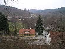 | |
| View over Fischweier into the lower Moosalb valley | |
| Location | Baden-Württemberg Calw Rastatt Karlsruhe |
|---|---|
| Reference no. | DE: 23746 |
| Length | 10.404 km [1] |
| Source | Southeast of Gaggenau-Moosbronn 48°49′58″N 8°24′06″E / 48.8328306°N 08.4015361°ECoordinates: 48°49′58″N 8°24′06″E / 48.8328306°N 08.4015361°E |
| Source height | ca. 479 m above sea level (NN) Hüttlesbrunnen |
| Mouth | Near Fischweier from the left and west into the upper Alb 48°53′27″N 8°27′02″E / 48.8909111°N 08.4505889°E |
| Mouth height | ca. 207 m above sea level (NN) |
| Descent | ca. 272 m |
| Basin | Rhine |
| Progression | Alb → Rhine → North Sea |
| Catchment | 27.7 km² [2] |
| Right tributaries | Schneebach |
The Moosalb is a river, around ten kilometres long, in the Northern Black Forest in the German state of Baden-Württemberg. It discharges from the left into the Alb near Fischweier.
See also
References
Literature
- TK25: topographic map, 1:25,000 series, Baden-Württemberg, Sheet No. 7116 Malsch
External links
-
 Media related to Moosalb (Alb) at Wikimedia Commons
 - Geodata viewer of the Baden-Württemberg State Office of Geoinformation and Land Development (Landesamt für Geoinformation und Landentwicklung Baden-Württemberg), especially the map sections/layers
- of the Landesanstalt für Umwelt, Messungen und Naturschutz Baden-Württemberg (LUBW)
- "LUBW-FG10": Rivers and streams, 1:10,000 scale
- "LUBW-GEZG": Catchment areas
- "LUBW-SCHUTZ": various maps of the individual nature reserve categories
- of the Landesanstalt für Umwelt, Messungen und Naturschutz Baden-Württemberg (LUBW)
This article is issued from Wikipedia - version of the 7/10/2016. The text is available under the Creative Commons Attribution/Share Alike but additional terms may apply for the media files.