L'Isle-aux-Allumettes, Quebec
| L'Isle-aux-Allumettes | |
|---|---|
| Municipality | |
 | |
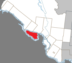 Location within Pontiac RCM | |
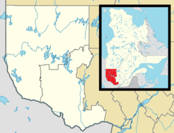 L'Isle-aux-Allumettes Location in SW Quebec | |
| Coordinates: 45°52′N 77°04′W / 45.867°N 77.067°WCoordinates: 45°52′N 77°04′W / 45.867°N 77.067°W[1] | |
| Country |
|
| Province |
|
| Region | Outaouais |
| RCM | Pontiac |
| Constituted | December 30, 1998 |
| Government[2] | |
| • Mayor | Winston Sunstrum |
| • Federal riding | Pontiac |
| • Prov. riding | Pontiac |
| Area[2][3] | |
| • Total | 234.20 km2 (90.43 sq mi) |
| • Land | 185.87 km2 (71.76 sq mi) |
| Population (2011)[3] | |
| • Total | 1,345 |
| • Density | 7.2/km2 (19/sq mi) |
| • Pop 2006-2011 |
|
| • Dwellings | 1,122 |
| Time zone | EST (UTC−5) |
| • Summer (DST) | EDT (UTC−4) |
| Postal code(s) | J0X 1M0 |
| Area code(s) | 819 |
| Highways |
|
| Website |
www -allumettes |
L'Isle-aux-Allumettes is a municipality in the Outaouais region, part of the Pontiac Regional County Municipality, Quebec, Canada. The municipality consists primarily of Allumette Island (in French Île aux Allumettes), and also includes Morrison Island, Marcotte Island, and some minor islets, all in the Ottawa River north of Pembroke.
In the past, the island and municipalities have been spelled in French in various ways:[4]
- Isle-des-Allumettes
- L'Île-Allumettes
- Île-aux-Allumettes
Geography
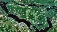
Allumette Island is 22 kilometres (14 mi) long and 12 kilometres (7.5 mi) wide, making it the largest island within the Ottawa River along its entire course. At this point the Ottawa River has widened into a lake, called Allumette Lake, which is 52 km (32 mi) long and has a total surface area of 120 km2 (46 sq mi).[5]
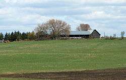
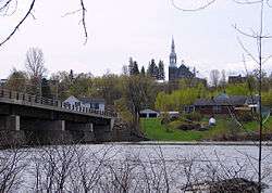
The municipality consists mostly of agricultural land. Its population centres are Chapeau, Desjardinsville, Demers Centre, and Saint-Joseph.[6]
History
The Kichesipirini Algonquins first occupied the site in order to maintain control of trade on the Ottawa River. For this reason, Samuel de Champlain named it Isle des Algoumequins during his trip of 1613. In 1650, this native population was almost entirely exterminated by the Iroquois.[5]
In his memoirs written during the second half of the 17th century, Nicolas Perrot made mention of the "One-Eyed Island otherwise called Allumette Island" ("Isle du Borgne autrement ditte l'Isle des Allumettes"). The name "One-Eyed" was a reference to the disability of Tessouat, an Algonquin chief in the region. The name "Allumettes" (literally meaning "matches") was first given to the rapids south-east of the island. A map from 1680 refers to these as Sault des Allumettes (Allumette Falls).[5]
It was not until 1818 that Europeans began to settle on the island. They worked mostly as loggers or for the Hudson's Bay Company which had a fur trading post just upstream at Fort William. The preferred transport route was still the river, so most families build their homes south on the island where the church of Saint-Alphonse-de-l'Île-aux-Allumettes Parish was built in 1840.[5] The Île-aux-Allumettes Township was formed in 1847,[7] and its first mayor was Andrew Whelan.[6]
An intense fire destroyed almost all the buildings in 1853 and, thereafter, the population rather settled in the northern part, on the current site of Chapeau village.[5] In 1874, the village of Chapeau separated from the township and became an incorporated municipality,[8] with Patrick Cunningham as the first mayor.[6]
In 1910, the parish of Saint-Joseph-de-l'Île-aux-Allumettes was established on the eastern part of the island, leading to the formation of the Municipality of L'Isle-aux-Allumettes-Partie-Est in 1920.[9]
On December 30, 1998, the municipality of Chapeau Village and the township municipalities of L'Isle-aux-Allumettes and L'Isle-aux-Allumettes-Part-East were regrouped into the new Municipality of L'Isle-aux-Allumettes.[4]
UFO Landing Incident
On May 11, 1969, near Chapeau, a farmer by the name of Leo-Paul Chaput was awakened at 2 am, and witnessed a brilliant white light emanating from a flat-bottomed domed craft, resembling a French WWI military helmet. The next morning, a 32 feet (9.8 m) wide circular imprint was found in the ground, with a ring of scorched grass 2.5 feet (0.76 m) wide, containing three indentations forming an equilateral triangle, with sides 15 feet (4.6 m) long, each dent 8 inches (20 cm) wide and 3 inches (7.6 cm) deep, suggesting a "landing tripod". A second smaller circle was also found, with a ring of scorched grass, but the triangle of indentations was smaller and not equilateral. A third scorched marking, although a semicircle, contained a pile of rocks. An explanation was offered that the circles were fairy rings, but this seems unlikely as they take years to achieve such a size and the witness insisted the markings were not there the day before.[10]
Demographics
Population
| Canada census – L'Isle-aux-Allumettes, Quebec community profile | |||
|---|---|---|---|
| 2011 | 2006 | 2001 | |
| Population: | 1,345 (-6.8% from 2006) | 1,443 (+4.2% from 2001) | 1,385 (-6.5% from 1996) |
| Land area: | 185.87 km2 (71.76 sq mi) | 185.87 km2 (71.76 sq mi) | 185.86 km2 (71.76 sq mi) |
| Population density: | 7.2/km2 (19/sq mi) | 7.8/km2 (20/sq mi) | 7.5/km2 (19/sq mi) |
| Median age: | 47.7 (M: 47.3, F: 47.9) | 43.7 (M: 43.5, F: 44.1) | 41.2 (M: 41.9, F: 40.0) |
| Total private dwellings: | 1,122 | 1,112 | 1,036 |
| Median household income: | $.N/A | $33,868 | $32,901 |
| Notes: 2011 Income data for this area has been suppressed for data quality or confidentiality reasons. – References: 2011[3] 2006[11] 2001[12] | |||
| Historical Census Data - L'Isle-aux-Allumettes, Quebec[13] | ||||||||||||||||||||||||||
|---|---|---|---|---|---|---|---|---|---|---|---|---|---|---|---|---|---|---|---|---|---|---|---|---|---|---|
|
|
| ||||||||||||||||||||||||
Language
Mother tongue:[11]
- English as first language: 78%
- French as first language: 21%
- Other as first language: <1 %
See also
References
- ↑ Reference number 350425 of the Commission de toponymie du Québec (French)
- 1 2 "L'Isle-aux-Allumettes". Répertoire des municipalités (in French). Ministère des Affaires municipales, des Régions et de l'Occupation du territoire. Retrieved 2011-06-22.
- 1 2 3 "L'Isle-aux-Allumettes census profile". 2011 Census of Population. Statistics Canada. Retrieved 2012-04-03.
- 1 2 "Municipalité de canton L'Isle-aux-Allumettes" (in French). Commission de toponymie du Québec. Retrieved 2008-04-14.
- 1 2 3 4 5 "Île aux Allumettes" (in French). Commission de toponymie du Québec. Retrieved 2008-04-14.
- 1 2 3 "Allumettes Island". Pontiac MRC Gateway. Archived from the original on October 7, 2006. Retrieved 2008-04-21.
- ↑ "Canton d'Île-aux-Allumettes" (in French). Commission de toponymie du Québec. Retrieved 2008-04-14.
- ↑ "Municipalité de village de Chapeau" (in French). Commission de toponymie du Québec. Retrieved 2008-04-14.
- ↑ "L'Isle-aux-Allumettes-Partie-Est" (in French). Commission de toponymie du Québec. Retrieved 2008-04-14.
- ↑ Chris Rutowski and Geoff Dittman, The Canadian UFO Report: The Best Cases Revealed, 2006, ISBN 1-55002-621-6
- 1 2 "2006 Community Profiles". Canada 2006 Census. Statistics Canada. March 30, 2011. Retrieved 2012-04-03.
- ↑ "2001 Community Profiles". Canada 2001 Census. Statistics Canada. February 17, 2012. Retrieved 2012-04-03.
- ↑ Statistics Canada: 1996, 2001, 2006, 2011 census
 |
Sheenboro / Ottawa River | Ottawa River, bridge to Chichester | Ottawa River, bridge to Waltham | |
| |
|
Ottawa River / | ||
| ||||
| | ||||
| Ottawa River / |
| Municipalities | |
|---|---|
| Townships | |
| Villages | |
| Unorganized territories | |
| |