Moulins-Engilbert
| Moulins-Engilbert | ||
|---|---|---|
|
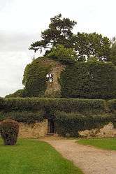
The ruins of the chateau | ||
| ||
 Moulins-Engilbert | ||
|
Location within Bourgogne-Franche-Comté region  Moulins-Engilbert | ||
| Coordinates: 46°59′16″N 3°48′41″E / 46.9878°N 3.8114°ECoordinates: 46°59′16″N 3°48′41″E / 46.9878°N 3.8114°E | ||
| Country | France | |
| Region | Bourgogne-Franche-Comté | |
| Department | Nièvre | |
| Arrondissement | Château-Chinon | |
| Canton | Moulins-Engilbert | |
| Intercommunality | Sud Morvan | |
| Government | ||
| • Mayor (2001–2008) | Jacques Guillemain | |
| Area1 | 40.76 km2 (15.74 sq mi) | |
| Population (1999)2 | 1,571 | |
| • Density | 39/km2 (100/sq mi) | |
| Time zone | CET (UTC+1) | |
| • Summer (DST) | CEST (UTC+2) | |
| INSEE/Postal code | 58182 / 58290 | |
| Elevation | 209–441 m (686–1,447 ft) | |
|
1 French Land Register data, which excludes lakes, ponds, glaciers > 1 km² (0.386 sq mi or 247 acres) and river estuaries. 2 Population without double counting: residents of multiple communes (e.g., students and military personnel) only counted once. | ||
.svg.png)
Moulins-Engilbert is a commune in the Nièvre department in central France.
Demographics
At the 1999 census, the population was 1571. On 1 January 2006, the estimate was 1685.
See also
References
| Wikimedia Commons has media related to Moulins-Engilbert. |
This article is issued from Wikipedia - version of the 2/11/2016. The text is available under the Creative Commons Attribution/Share Alike but additional terms may apply for the media files.