Mount Agung
| Mount Agung | |
|---|---|
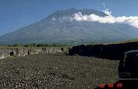 Mount Agung in 1989 | |
| Highest point | |
| Elevation | 3,031 m (9,944 ft) [1][2] |
| Prominence |
3,031 m (9,944 ft) [1] Ranked 87th |
| Isolation | 105 kilometres (65 mi) |
| Listing |
Ultra Ribu |
| Coordinates | 8°20′27″S 115°30′12″E / 8.34083°S 115.50333°ECoordinates: 8°20′27″S 115°30′12″E / 8.34083°S 115.50333°E [1] |
| Naming | |
| Translation | Paramount, The Great Mountain |
| Geography | |
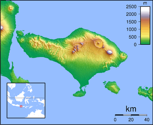 Mount Agung | |
| Geology | |
| Mountain type | Stratovolcano |
| Last eruption | 1963 to 1964[3] |
| Climbing | |
| Easiest route | Hike |
Mount Agung or Gunung Agung is a mountain in Bali, Indonesia. This stratovolcano is the highest point on the island. It dominates the surrounding area, influencing the climate. The clouds come from the west and Agung takes their water so that the west is lush and green while the east dry and barren.
The Balinese believe that Mount Agung is a replica of Mount Meru, the central axis of the universe. One legend holds that the mountain is a fragment of Meru brought to Bali by the first Hindus. The most important temple on Bali, Pura Besakih, is located high on the slopes of Gunung Agung.[4]
Gunung Agung last erupted in 1963-1964 and is still active, with a large and very deep crater which occasionally belches smoke and ash. From a distance, the mountain appears to be perfectly conical, despite the existence of the large crater.
From the peak of the mountain, it is possible to see the peak of Mount Rinjani on the island of Lombok, although both mountains are frequently covered in clouds.
1963-64 eruption
On February 18, 1963, local residents heard loud explosions and saw clouds rising from the crater of Mount Agung. On February 24, lava began flowing down the northern slope of the mountain, eventually traveling 7 km in the next 20 days. On March 17, the volcano erupted (VEI 5), sending debris 8 to 10 km into the air and generating massive pyroclastic flows.[5] These flows devastated numerous villages, killing approximately 1500 people. Cold lahars caused by heavy rainfall after the eruption killed an additional 200. A second eruption on May 16 led to pyroclastic flows that killed another 200 inhabitants.[6]
The lava flows missed, sometimes by mere yards, the Mother Temple of Besakih. The saving of the temple is regarded by the Balinese people as miraculous and a signal from the gods that they wished to demonstrate their power but not destroy the monument the Balinese faithful had erected.
Andesite was the dominant lava type with some samples mafic enough to be classified as basaltic andesite.[7]
Recreation
There are two main routes up the mountain; one from Pura Besakih proceeds to the higher western peak and starts at approximately 1,100 m (3,610 ft).
The second route, reputed to take five hours (one-way), proceeds to the southern peak and commences higher from Pura Pasar Agung, near Selat.
A path connecting the southern ascent with the western ascent is available during the dry season. Cecilie Scott[8] provides an account of the ascent from Pura Pasar Agung to the southern peak.
Greg Slayden describes a climb from Besakih[9] claimed to have taken a remarkable four and a half hours to the peak and Ken Taylor[10] that took much longer and included getting lost.
Guides are available in Besakih and also in Pura Pasar Agung. The mountain can also be climbed without a guide. The climb from Besakih is quite tough. It is sometimes tackled as a single climb generally starting about 10 p.m. for a dawn arrival at the peak and sometimes with an overnight camp about three quarters of the way up.
The climb from Pura Pasar Agung generally starts around 2:30 a.m. for a dawn arrival.
It is far harder than the more popular Balinese climb up Gunung Batur. It is not a mountain that needs ropes and not quite high enough for altitude sickness, but adverse weather conditions develop quickly and warm waterproof clothing is required and should be carried. A dawn arrival at the top is recommended in order to avoid clouds that typically cover the top from approximately 9 a.m. onwards. There is no water available along the route.
For the Besakih route proceed through the temple complex then continue on a path that travels continuously upwards on a steep narrow spur through open forest and jungle most of the way.
There is little potential to get lost until the route opens up towards the top where the correct route doubles backwards. Many climbers miss this turn and continue up a small valley which can be climbed out of with some difficulty.
See also
- List of Southeast Asian mountains
- List of Ultras of Malay Archipelago
- List of volcanic eruptions by death toll
- List of volcanoes in Indonesia
- Mother Temple of Besakih
| Wikimedia Commons has media related to Mount Agung. |
Notes
- 1 2 3 "Mountains of the Indonesian Archipelago" Peaklist.org. Note: Sources differ on the elevation of this peak. GVP gives an elevation of 3,142 m for Mount Agung. Peaklist.org gives this explanation in its footnotes: The elevation for Agung on most websites is 3142m. Analysis of IFSAR data and site visits by climbers indicated that the true elevation is close to 3031. Retrieved 2012-04-06.
- ↑ "Gunung Agung, Indonesia" Peakbagger.com. Retrieved 2012-04-06.
- ↑ "Agung". Global Volcanism Program. Smithsonian Institution. Retrieved 2007-05-04.
- ↑ Pringle, pp. 4,63
- ↑ "Geology of Mt. Agung". Pusat Vulkanologi & Mitigasi Bencana Geologi — VSI. Archived from the original on 2008-03-27. Retrieved 2010-11-20.
- ↑ Zen, M. T.; Hadikusumo, Djajadi (December 1964). "Preliminary report on the 1963 eruption of Mt.Agung in Bali (Indonesia)". The SAO/NASA Astrophysics Data System. Retrieved 2009-04-26.
- ↑ Self, S., and M.R. Rampino, 2012: The 1963-1964 eruption of Agung volcano (Bali, Indonesia). Bull. Vulcanol., 74, 1521-1536
- ↑ http://www.turtledreams.org/mountain-1
- ↑ http://www.peakbagger.com/climber/ascent.aspx?aid=1281
- ↑ http://urremote.com/index.php?title=Climbing_Gunung_Agung describes a climb
References
- Pringle, Robert (2004). Bali: Indonesia's Hindu Realm; A short history of. Short History of Asia Series. Allen & Unwin. ISBN 1-86508-863-3.
External links
- Agung and Batur, Bali, Lesser Sunda, Indonesia
-
 Mount Agung travel guide from Wikivoyage
 - "Gunung Agung, Indonesia" on Peakbagger