Mount Everett
| Mount Everett | |
|---|---|
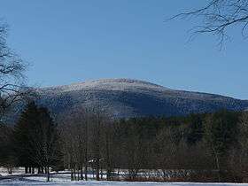 View from Bears Den Road, Sheffield, MA | |
| Highest point | |
| Elevation | 2,624 ft (800 m) |
| Parent peak | 42° 06' 07"N, 73° 25' 57"W |
| Coordinates | 42°06′07″N 73°25′57″W / 42.10194°N 73.43250°WCoordinates: 42°06′07″N 73°25′57″W / 42.10194°N 73.43250°W |
| Geography | |
| Location | Southwest Berkshire County, Massachusetts |
| Parent range | Taconic Mountains |
| Geology | |
| Age of rock | Ordovician |
| Mountain type | Thrust fault; metamorphic rock |
| Climbing | |
| Easiest route | Mount Everett Road and Appalachian Trail |
Mount Everett at 2,602 ft - or 793.1 m - is the highest peak in the south Taconic Mountains of Massachusetts, Connecticut and New York. The mountain is known for its expansive views of the southern Taconics and Berkshires; for its old growth pitch pine and scrub oak; for the Appalachian Trail's north-south traverse of its shoulders and summit grounds, and for its rare plant and animal communities. The mountain is named after a 19th Century governor of Massachusetts, Edward Everett. The name was proposed in 1841 by Edward Hitchcock, geologist to the state, in his "Final Report on the Geology of Massachusetts." [1] Hitchcock wrote that at the time of his proposal, the mountain was known as Bald Mountain or Ball Mountain. Some old maps at the Sheffield Historical Society also label the mountain as "The Dome".
Details
Guilder Pond, a highland lake, is located in the cirque-like ravine between Mount Everett and Undine Mountain to the north; Race Brook Falls, a popular series of waterfalls, cascades from a common ledge between Mount Everett and Mount Race to the south, losing approximately 600 feet of elevation in 1200 feet of brook. A seasonal auto road climbs to just short of the summit, though the road's upper reaches have been closed to motorized vehicles for many years.
The summit and west side of Mount Everett is located in the town of Mount Washington; the east slopes are located in Sheffield, Massachusetts. Much of the mountain is located within the Mount Everett State Reservation; other parcels are part of Mount Washington State Forest or conservation easements.
The east side of the mountain drains into Race Brook, thence into Schenob Brook, the Hubbard Brook, the Housatonic River, and Long Island Sound. The west side drains into Guilder Brook and City Brook, thence into Bash Bish Brook, the Roeliff Jansen Kill, the Hudson River and New York Bay of the Atlantic Ocean.
References
- ↑ Final Report on the Geology of Massachusetts 1841, page 238
- Massachusetts Trail Guide (2004). Boston: Appalachian Mountain Club.
External links
- South Taconic Range trail map.
- Mount Washington State Forest. Massachusetts DCR.
- Mount Everett State Reservation. Massachusetts Department of Conservation and Recreation.
- Mount Washington State Forest map
- Berkshire Natural Resource Council
- Berkshire Chapter of the Appalachian Mountain Club
- Commonwealth Connections proposal PDF download. Retrieved March 2, 2008.
- Appalachian Trail Conservancy.