Hokkaido Koma-ga-take
| Mount Hokkaidō-Komagatake | |
|---|---|
| 北海道駒ヶ岳 | |
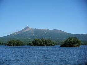 View from Lake Ōnuma (August 2008) | |
| Highest point | |
| Elevation | 1,131 m (3,711 ft) |
| Listing |
List of mountains and hills of Japan by height List of volcanoes in Japan |
| Coordinates | 42°03′48″N 140°40′38″E / 42.06333°N 140.67722°ECoordinates: 42°03′48″N 140°40′38″E / 42.06333°N 140.67722°E |
| Geography | |
| Topo map |
Geographical Survey Institute 25000:1 駒ヶ岳 50000:1 室蘭 |
| Geology | |
| Age of rock | Quaternary |
| Mountain type | stratovolcano |
| Volcanic arc/belt | Northeastern Japan Arc |
| Last eruption | September to November 2000 |

Hokkaidō Koma-ga-take (北海道駒ヶ岳 Hokkaidō Koma-ga-take), also Oshima Koma-ga-take (渡島駒ヶ岳), Oshima Fuji (渡島富士), or just Koma-ga-take (駒ヶ岳) is a 1131-meter adesitic stratovolcano[1] on the border between Mori, Shikabe, and Nanae, Hokkaidō, Japan.
Occurrence of volcanic activity started some 30000 years ago. Following roughly 5000 years of dormancy, volcanic activity at Mount Koma-ga-take restarted at the start of the 17th century. Since then, there have been at least 50 recorded volcanic events at Mount Koma-ga-take.[2]
 Relief Map
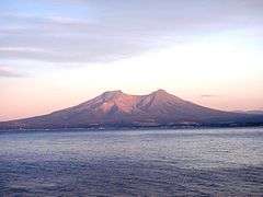 Viewed from NW.
 Viewed from ESE.
References
- ↑ "HOKKAIDO KOMA-GA-TAKE". Quaternary Volcanoes of Japan. Geological Survey of Japan, AIST. 2006. Retrieved 2009-06-22.
- ↑ 神沼克伊,小山悦郎 日本の火山を科学する 日本列島津々浦々、あなたの身近にある108の活火山とは? ソフトバンククリエイティブ 2011. ISBN 978-4797361308.
- Geographical Survey Institute
- Teikoku's Complete Atlas of Japan, Teikoku Shoin Co., Ltd., Tokyo 1990, ISBN 4-8071-0004-1
External links
| Wikimedia Commons has media related to Mount Hokkaido-Komagatake. |
- Hokkaido-Komagatake - Japan Meteorological Agency (Japanese)
- "Hokkaido-Komagatake: National catalogue of the active volcanoes in Japan" (PDF). - Japan Meteorological Agency
- Hokkaido-Komagatake Volcano - Geological Survey of Japan
- Hokkaido-Komagatake - Smithsonian Institution: Global Volcanism Program
This article is issued from Wikipedia - version of the 11/18/2016. The text is available under the Creative Commons Attribution/Share Alike but additional terms may apply for the media files.