Mount Morris Dam
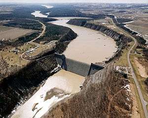
The Mount Morris Dam is a concrete dam on the Genesee River. It is located south of Rochester, New York in the towns of Leicester and Mount Morris in Livingston County, New York, next to Letchworth State Park.
History
The Mt. Morris Dam was built between 1948 and 1952 by the Buffalo District office of the U.S. Army Corps of Engineers (USACE). The project was authorized by the United States Congress in the Flood Control Act of 1944 at a cost of $25 million.
Records show that the Genesee River Valley and the City of Rochester had experienced flooding since 1800. The flood of 1865, which developed flows exceeding 24 million U.S. gallons (91 megaliters) per minute, resulted in massive destructions with flows equating half the flows of Niagara Falls. Severe floods occurred every seven years between 1865 and 1950.[1]
The USACE states that, in the years since the completion of the dam, an estimated $1 billion in flooding damages have been prevented, and that during Hurricane Agnes in 1972, $210 million in damages was prevented, primarily to the city of Rochester. The water inflow due to Hurricane Agnes exceeded the storage capacity of the reservoir and it was necessary to release water through the gates of the dam, causing minor downstream flooding. These releases were made to prevent overtopping of the spillway. Had the spillway overtopped, accumulated debris in the reservoir would have passed downstream, causing log jams and additional damage. Inflows of this magnitude are only expected to happen an average of every 300 years.[1]
Commemorations
June 2002 commemorated the 50th anniversary of the completion of Mount Morris Dam. A celebration and dedication of the commemorative kiosk was held to honor and recognize the men and women employed by the U.S. Army Corps of Engineers, Buffalo District and Mount Morris Dam Builders, 1948-1952. The kiosk rests on a foundation of bricks, each of which is inscribed with the name and occupation of the builders.[2]
Visiting Centers
The William B. Hoyt II Visitor Center at Mount Morris Dam, opened by the U.S. Army Corps of Engineers in 1999, was built to accommodate the thousands of people who visit the dam each year. This 5,400-square-foot (500 m2) center features a large atrium, museum, theater and public restroom facilities, and provides a relaxing, educational experience to visitors.[1]
Project facts
General
Distance from mouth of Genesee River: 67 miles (108 km).
Drainage area above dam: 1,075 sq mi (2,780 km2).
Drainage area below dam: 1,391 sq mi (3,600 km2).
Dam
Type: Concrete Gravity/Dry.
Total length: 1,028 ft (313 m).
Top width: 20 ft (6.1 m).
Maximum height above river bed: 230 ft (70 m).
Top elevation: 790 ft (240 m) above sea level.
Spillway
Total length: 550 ft (170 m).
Crest elevation: 760 ft (230 m).
Reservoir
Length in River Miles: 17 miles (27 km) at Maximum flood control pool.
Water Surface Elevation: 760 ft (230 m) above sea level at Maximum flood control pool.
Storage Volume: 301,853 acre feet (372,330,000 m3) at Maximum flood control pool.
Outlet Works
Type: Rectangular conduits.
Location: Base of spillway.
Real-time Genesee River data may be obtained at: http://www.erh.noaa.gov/er/nerfc
See also
References
- Mount Morris Dam. U.S. Army Corps of Engineers (USACE). Retrieved December 2009, from http://www.lrb.usace.army.mil/WhoWeAre/MMD/MMD.html
- Pieces of the Past: Artifacts, Documents, and Primary Sources from Letchworth Park History. Retrieved December 2009, from http://www.letchworthparkhistory.com/flood.html
- Mt. Morris RockWiki. Army Corps of Engineers (USACE). Retrieved December 2009, from http://rocwiki.org/Mt._Morris_Dam
External links
- Mount Morris Dam and Recreational Area - official site
- Mt. Morris Dam construction photo
- NYS Parks - Letchworth State Park
Coordinates: 42°44′00″N 77°54′25″W / 42.73333°N 77.90694°W