Mount Myōjin
| Mount Myōjin | |
|---|---|
| 明神岳 | |
 Mount Myōjin from east | |
| Highest point | |
| Elevation | 1,432 m (4,698 ft) |
| Listing | List of mountains and hills of Japan by height |
| Coordinates | 34°21′N 136°5′E / 34.350°N 136.083°E |
| Naming | |
| Pronunciation | [mjoːdʑindake] |
| Geography | |
| Location | Matsusaka, Mie and Kawakami, Nara, Japan |
| Parent range | Daikō Mountains |
Mount Myōjin (明神岳 Myōjin-dake) is a 1,432 m (4,698 ft) mountain, on the border of Matsusaka, Mie and Kawakami, Nara, Japan. This mountain is one of Daikō Mountains.
Routes
There are two major routes to the top of Mount Myōjin. The route from Maakodani Tozanguchi takes about three hours. The other route is via Myōjindaira from Ōmata Bus Stop of Nara Kōtsu. It takes about three and half hours.
Access
- Ōmata Bus Stop of Nara Kōtsu
Gallery
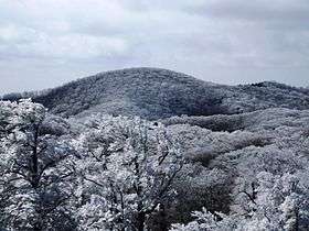
 Mount Myōjin from Mount Hinokizuka Okumine (03/2009)
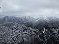 Mount Myōjin from Mount Azami (03/2009)
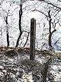 The top of Mount Myōjin (03/2009)
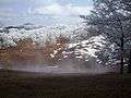 Myojindaira on the way to Mount Myōjin (03/2009)
 On the way to Mount Myōjin (03/2009)
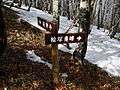 A view at Mount Myōjin (03/2009)
 The entrance of a climbing route to Mount Myōjin (03/2009)
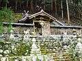 Sasano Shrine at Ōmata (03/2009)
References
- Ōdaigahara, Takami, Kurosoyama, Shobunsha, 2008
- Official Home Page of the Geographical Survey Institute in Japan
This article is issued from Wikipedia - version of the 4/22/2015. The text is available under the Creative Commons Attribution/Share Alike but additional terms may apply for the media files.