Mount Nōgōhaku
| Mount Nōgōhaku | |
|---|---|
| 能郷白山 | |
 Mount Nōgōhaku | |
| Highest point | |
| Elevation | 1,617.33 m (5,306.2 ft) [1] |
| Coordinates | 35°45′44″N 136°30′51″E / 35.76222°N 136.51417°ECoordinates: 35°45′44″N 136°30′51″E / 35.76222°N 136.51417°E [2] |
| Geography | |
 Mount Nōgōhaku Location in Japan | |
| Location |
Gifu Prefecture Fukui Prefecture Japan |
| Parent range | Ryōhaku Mountains |
| Topo map | Geographical Survey Institute, 25000:1 能郷白山, 50000:1 岐阜 |
| Climbing | |
| First ascent | Taichō in 718 |
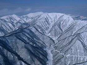
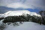
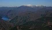
Mount Nōgōhaku (能郷白山 Nōgōhaku-san) is located on the borders of Gifu and Fukui prefectures in Japan. It is part of the Ryōhaku Mountains and serves as the drainage divide between the Pacific Ocean and the Japan Sea. There is one triangulation station at the top of the mountain.
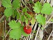
Fragaria iinumae was discovered at first in this Mountain and the name Nōgō Fragaria (ノウゴウイチゴ・能郷苺 Nōgō Ichigo) was given.[3][4]
History
- 718: Mountain first climbed by Taichō.
- 1897: Shinto shrine of Mount Nōgōhaku Shrine (能郷白山神社 Nōgōhaku-san Jinja) was reconstructed.
- 1965: A large landslide was created by a major flood in the fall.
Gallery
|
See also
| Wikimedia Commons has media related to Mount Nōgōhaku. |
References
- ↑ "Information inspection service of the Triangulation station" (in Japanese). Geospatial Information Authority of Japan,(岐阜-能郷白山). Archived from the original on June 9, 2009. Retrieved December 6, 2010.
- ↑ "Mountains altitude list in Japan (Gife prefecture)" (in Japanese). Geospatial Information Authority of Japan. Retrieved December 6, 2010.
- ↑ "Alpine plant in Japan" (in Japanese). YAMA-KEI Publishers,ISBN 4-635-09019-1. 1994.
- ↑ Alpen guide Mount Haku and mountains in Hokuriku (in Japanese). YAMA-KEI Publishers. 2000. ISBN 4-635-01321-9.
This article is issued from Wikipedia - version of the 9/13/2016. The text is available under the Creative Commons Attribution/Share Alike but additional terms may apply for the media files.