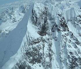
Mount Orville
| Mount Orville | |
|---|---|
 | |
| Highest point | |
| Elevation | 10,495 ft (3,199 m) [1] |
| Prominence | 1,795 ft (547 m) [1] |
| Coordinates | 58°44′10″N 137°16′20″W / 58.73611°N 137.27222°WCoordinates: 58°44′10″N 137°16′20″W / 58.73611°N 137.27222°W [1] |
| Geography | |
 Mount Orville | |
| Parent range | Fairweather Range, Saint Elias Mountains |
| Topo map | USGS Mount Fairweather C-4 Quadrangle |
| Climbing | |
| First ascent | 1995 by Steve Carroll, Philip Kauffman and Patrick Simmons |
| Easiest route | snow/ice climb |
Mount Orville is a high peak of the Fairweather Range, the southernmost part of the Saint Elias Mountains. It is included in Glacier Bay National Park. The peak is the lower of a pair of peaks, Mounts Wilbur and Orville, named after the Wright Brothers.
Though not a particularly high peak in absolute terms, Mount Orville does stand quite high above local terrain, due to its proximity to the ocean: the summit is only 7.5 miles from tidewater at the head of Lituya Bay to the southwest.
Ascents
The first ascent by Steven Carroll, Philip Kauffman and Patrick Simmons was ill fated. The three climbers were killed in an avalanche, on the descent, that was caused by unseasonable changes in weather conditions.[2]
In April 2012 professional mountaineer Florian Hill and Will Wacker attempted Mount Orville several times but had to cut off the expedition due bad weather.[3]
References
- 1 2 3 "Mount Orville". Peakbagger.com. Retrieved 14 Dec 2013.
- ↑ http://bivouac.com/TripPg.asp?TripId=5808
- ↑ "Florian Hill – Der Mythos Mount Orville". NATIONAL GEOGRAPHIC. Retrieved 2015-11-01.