Mount Sannosawa
| Mount Sannosawa | |
|---|---|
| 三ノ沢岳 | |
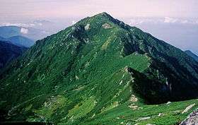 Mount Sannosawa and Sannosawa cirque on east side seen from the direction of Mount Hōken | |
| Highest point | |
| Elevation | 2,846 m (9,337 ft) |
| Coordinates | 35°46′00″N 137°47′38″E / 35.76667°N 137.79389°ECoordinates: 35°46′00″N 137°47′38″E / 35.76667°N 137.79389°E |
| Geography | |
| Location |
Kiso District, Japan |
| Parent range | Kiso Mountains |
| Climbing | |
| Easiest route | Komagatake Ropeway |
Mount Sannosawa (三ノ沢岳 Sannosawa-dake) is amongst the Kiso Mountains, located in the Kiso District, Nagano Prefecture, in the Chūbu region of Japan. It is 2,846 m (9,337 ft) tall. It is composed of Granite, and has a 120 m (394 ft) long 30 m (98 ft) wide cirque covered in dense vegetation, mainly pine trees.[1] There is the "Sannosawa cirque". Glacial expansion has created a gully, just underneath the cirque.[1] A lot of Alpine plant grow naturally. Name River and Ina River (Tributary of Kiso River) that become the sources flow to the Ise Bay of Pacific Ocean. There is the tributary called "Sannosawa" around Mount Sannosawa. Komagatake Ropeway is used to climb.[2]
Scenery of Mount Sannosawa
 |
 |
 |
 |
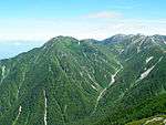
| Mount Sannosawa seen from Mount Hōken |
Mount Sannosawa seen from Mount Hinokio |
Mount Sannosawa seen from southwest |
Mount Kisokoma and Mount Hōken seen from Mount Sannosawa |
See also
| Wikimedia Commons has media related to Mount Sannosawa. |
References
- 1 2 Horie, Shoji (1972), Paleolimnology of Lake Biwa and the Japanese Pleistocene (5 ed.), Kyoto University, p. 12
- ↑ "Mountains information" (in Japanese). Komagane Tourist Association. Retrieved 2011-04-24.
This article is issued from Wikipedia - version of the 9/24/2016. The text is available under the Creative Commons Attribution/Share Alike but additional terms may apply for the media files.