Mount Solomons
| Mount Solomons | |
|---|---|
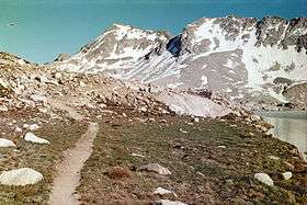 Mount Solomons (center left) from the John Muir Trail | |
| Highest point | |
| Elevation | 13,040 ft (3,975 m) NAVD 88[1] |
| Prominence | 554 ft (169 m) [1] |
| Coordinates | 37°06′23″N 118°40′26″W / 37.1063255°N 118.6739968°WCoordinates: 37°06′23″N 118°40′26″W / 37.1063255°N 118.6739968°W [2] |
| Geography | |
 Mount Solomons  Mount Solomons
| |
| Location | Fresno County, Kings Canyon National Park, California, U.S. |
| Parent range | Sierra Nevada |
| Climbing | |
| First ascent | 1929 by M.H. Pramme and T.F. Harms[3] |
| Easiest route | Scramble, class 2[3] |
Mount Solomons is a peak in the Sierra Nevada mountain range in the U.S. state of California. It rises to 13,040 feet (3,975 m) directly above Muir Pass. Mount Solomons was named after Theodore Solomons, an explorer of the Sierra Nevada mountains, who mapped and established what is now the northern half of John Muir Trail.[4]
The peak is on the Goddard Divide in Kings Canyon National Park and overlooks Evolution Basin.[5] A scramble from the Muir trail at Muir pass leads to the summit.[3]
References
- 1 2 "Mount Solomons, California". Peakbagger.com. Retrieved 2012-12-16.
- ↑ "Mount Solomons". Geographic Names Information System. United States Geological Survey. Retrieved 2012-12-16.
- 1 2 3 Secor, R.J. (2009). The High Sierra Peaks, Passes, and Trails (3rd ed.). Seattle: The Mountaineers. p. 281. ISBN 9780898869712.
- ↑ Browning, Peter (1986). Place Names of the Sierra Nevada. Berkeley: Wilderness Press. p. 204. ISBN 0899970478.
- ↑ "Mount Solomons". SummitPost.org. Retrieved 2012-03-18.
This article is issued from Wikipedia - version of the 8/5/2016. The text is available under the Creative Commons Attribution/Share Alike but additional terms may apply for the media files.