Mount Yōrō
| Mount Yōrō | |
|---|---|
| 養老山 | |
 Mount Yōrō | |
| Highest point | |
| Elevation | 859.3 m (2,819 ft) |
| Coordinates | 35°15′47″N 136°31′24″E / 35.26306°N 136.52333°ECoordinates: 35°15′47″N 136°31′24″E / 35.26306°N 136.52333°E [1] |
| Geography | |
| Location |
Yōrō and Ōgaki Gifu Prefecture, Japan |
| Parent range | Yōrō Mountains |
| Topo map | Geographical Survey Institute, 25000:1 養老, 50000:1 津島[2] |
| Climbing | |
| Easiest route | Yōrō Ropeway |
Mount Yōrō (養老山 Yōrō-san) is a mountain located in the cities of Yōrō and Ōgaki, Gifu Prefecture, Japan. Its peak rises 859 m (2,818 ft)[3] and is the main peak in the Yōrō Mountains that stretch through the region. It was previously called Mount Tagi (多芸山 Tagi-yama).
There is a large park with many attractions between the town of Yōrō and the mountain. From the park, there are trails to the Yōrō waterfall and to the summit of the mountain.
Reaching the summit
There are two options for reaching the summit. The easiest way to reach the summit is to take the Yōrō Ropeway from the parking lot above Yōrō Falls. The second option is to hike up the mountain using trails that also begin from the parking lot above Yōrō Falls. There is a record book in which climbers can sign their name to record their journey. The trail to the top is about 4 km (2.5 mi) long.
Access
The town of Yōrō is on the Kintetsu Yōrō Line. It can be reached from Ōgaki in the north, or from Kuwana in the south. Ōgaki is on the JR Tōkaidō Main Line.
Gallery
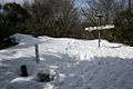 Top and Triangulation station in winter
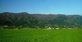 Mount Yōrō from the foot Yōrō, Gifu
 Yōrō Waterfall at entrance in the hiking trail
See also
| Wikimedia Commons has media related to Mount Yoro. |
References
- ↑ "Mountains altitude list in Japan(Gife prefecture)" (in Japanese). Geospatial Information Authority of Japan. Retrieved December 24, 2010.
- ↑ "Map inspection service" (in Japanese). Geospatial Information Authority of Japan. Retrieved December 24, 2010.
- ↑ Yōrō-chō Tourist Sightseeing Association. (Japanese) Yōrō Town. Accessed June 23, 2008.
External links
- Yōrō-chō Tourist Sightseeing Association (Japanese)
- Mount Yōrō Hiking Map (Japanese)