Cherry Brook
| Cherry Brook | |
| River | |
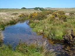 Cherry Brook and Smith Hill Farm | |
| Country | England |
|---|---|
| County | Devon |
| Source | 50°36′18″N 3°57′11″W / 50.605°N 3.953°W |
| - location | North of Lower White Tor |
| - elevation | 490 m (1,608 ft) |
| Mouth | 50°32′49″N 3°55′55″W / 50.547°N 3.932°W |
| - location | West Dart River |
| - elevation | 300 m (984 ft) |
| Length | 8 km (5 mi) |
The Cherry Brook is a tributary of the West Dart River on Dartmoor, Devon, England.
It rises about a kilometre north of Lower White Tor in the open moorland and flows in a generally southerly direction past Powder Mills, the site of a 19th-century gunpowder factory, then under a clapper bridge where it turns easterly and passes under the B3212 road at Higher Cherrybrook Bridge. It then continues southwards, passes to the east of Smith Hill and then meets the B3357 road at Lower Cherrybrook Bridge where it is joined by the Muddilake Brook that has its source just west of Crockern Tor. The Cherry Brook then winds its way down to meet the West Dart River near Sherberton.
References
- Ordnance Survey 1:25,000 scale map of Dartmoor. OL28.
- Hemery, Eric (1983). High Dartmoor. London: Robert Hale. pp. 434–442. ISBN 0-7091-8859-5.
| Wikimedia Commons has media related to Cherry Brook. |
This article is issued from Wikipedia - version of the 4/24/2016. The text is available under the Creative Commons Attribution/Share Alike but additional terms may apply for the media files.