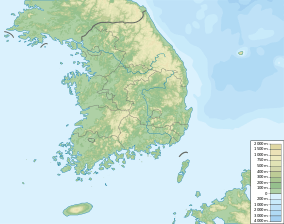
Munboksan
| Munboksan | |
|---|---|
| Korean name | |
| Hangul | 문복산 |
| Hanja | 文福山 |
| Revised Romanization | Munboksan |
| McCune–Reischauer | Munboksan |
 Munsusan Gyeongju, North Gyeongsang Province and Cheongdo County, South Korea | |
| Highest point | |
| Elevation | 1,015 m (3,330 ft) |
| Coordinates | 35°40′34″N 129°02′02″E / 35.676°N 129.034°ECoordinates: 35°40′34″N 129°02′02″E / 35.676°N 129.034°E |
| Geography | |
| Location | Gyeongju, North Gyeongsang Province and Cheongdo County, South Korea |
Munboksan is a mountain located in Gyeongju, North Gyeongsang Province and Cheongdo County, South Korea. It has an elevation of 1,015 m (3,330 ft).[1] It is part of the Yeongnam Alps mountain range.
See also
- Geography of Korea
- List of mountains in Korea
- List of mountains by elevation
- Mountain portal
- South Korea portal
References
- ↑ Park (박), Jong-hyeon (종현) (13 June 2014). "영남의 알프스 '가지산'을 가다 (Go to Yeongnam Alps' Gajisan)" (in Korean). 투데이신문 (Today News). Retrieved 14 March 2015.
External links
This article is issued from Wikipedia - version of the 12/6/2015. The text is available under the Creative Commons Attribution/Share Alike but additional terms may apply for the media files.