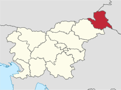
Mura Statistical Region
| Mura Statistical Region Pomurska statistična regija | |
|---|---|
| Statistical region | |
 | |
| Municipalities | 27 |
| Largest city | Murska Sobota |
| Area | |
| • Total | 1,337 km2 (516 sq mi) |
| Population (2015) | |
| • Total | 116,434 |
| • Density | 87/km2 (230/sq mi) |
| Statistics | |
| • Households | 44776 |
| • Employed | 33623 |
| • Registered unemployed | 9094 |
| • College/university students | 4133 |
| • Regional GDP: |
EUR 1.435 bn (EUR 12,267 per capita) |
The Mura Statistical Region[1][2][3][4] (Slovene: Pomurska statistična regija) is a statistical region in northeast Slovenia. It is predominantly agricultural with field crops representing over three-quarters of the total agricultural area (twice as much as the Slovene average). Climate and soil combined have made it the region with the highest crop production, but its geographical position and inferior infrastructure put it at a disadvantage and it is the region of Slovenia with the lowest GDP per capita (EUR 12,267) and the highest rate of registered unemployment.[5]
Municipalities
The Mura Statistical Region comprises the following 27 municipalities:
- Apače
- Beltinci
- Cankova
- Črenšovci
- Dobrovnik
- Gornja Radgona
- Gornji Petrovci
- Grad
- Hodoš
- Kobilje
- Križevci
- Kuzma
- Lendava
- Ljutomer
- Moravske Toplice
- Murska Sobota
- Odranci
- Puconci
- Radenci
- Razkrižje
- Rogašovci
- Sveti Jurij ob Ščavnici
- Šalovci
- Tišina
- Turnišče
- Velika Polana
- Veržej
Demographics
The population in 2015 was 116,434. It has a total area of 1,337 km².
Economy
Employment structure: 57.3% services, 39.9% industry, 2.7% agriculture.
Tourism
It attracts 10.2% of the total number of tourists in Slovenia, most being from Slovenia (62.4%).
Transportation
- Length of motorways: 64.5 km
- Length of other roads: 3,103.5 km
References
- ↑ OECD. 2012. OECD Environmental Performance Reviews: Slovenia 2012. OECD Publishing, p. 324.
- ↑ Lapuh, Lucija. 2016. Measuring the Impact of the Recession on Slovenian Statistical Regions and their Ability to Recover. Acta geographica Slovenica 56(2): 247–256, pp. 252ff.
- ↑ Šprah, Lilijana, Tatjana Novak, & Jerneja Fridl. 2016. The Wellbeing of Slovenia's Population by Region: Comparison of Indicators with an Emphasis on Health. Acta geographica Slovenica 54(1): 67–87, p. 68.
- ↑ Boršič, Darja, & Alenka Kavkler. 2009. Modeling Unemployment Duration in Slovenia Using Cox Regression Models. Transition Studies Review 54(1): 145–156, p. 148.
- ↑ "Labour force, Slovenia, November 2010 - final data". Statistical Office of the Republic of Slovenia. 18 January 2011. Retrieved 10 February 2011.
Coordinates: 46°39′00″N 16°10′00″E / 46.65000°N 16.16667°E