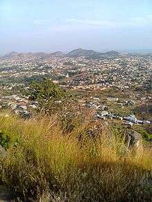
Ngaoundéré
| Ngaoundéré | |
|---|---|
 Ngaoundéré Location in Cameroon | |
| Coordinates: 7°19′00″N 13°35′00″E / 7.31667°N 13.58333°ECoordinates: 7°19′00″N 13°35′00″E / 7.31667°N 13.58333°E | |
| Country |
|
| Region | Adamawa |
| Department | Vina |
| Elevation | 1,212 m (3,976 ft) |
| Population (2005)(Census) | |
| • Total | 152,698 |
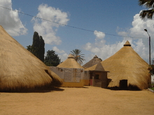
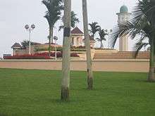
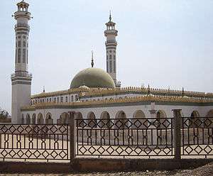
Ngaoundéré or N'Gaoundéré is the capital of the Adamawa Region of Cameroon. It had a population of 152,700 (at the 2005 Census). According to the movie Les Mairuuwas - Maitre de l'eau from the University of Tromsø the population has rapidly risen to 1,000,000 (October 2016) owing to mass immigration from the Central African Republic and the perceived danger from Boko Haram in northern Cameroon. It lies at the northern end of the railway to Yaoundé and is also home to an airport. Attractions in the city include the Lamido Palace and the Lamido Grand Mosque. The town is named after a nearby mountain on its eponymous plateau; the mountain's name is the Mbum for "navel mountain".
History
The site of modern Ngaoundéré had previously been occupied by a Mbum capital but the present city dates to around 1835, when it was founded by the Fulani leader Ardo Njobdi. The Fula continued to hold the area during the 19th century and Ngaoundéré was visited in 1882 by Robert Flegel.[1] Ardo Muhammadu Abbo signed a protection agreement with the German explorer Siegfried Passarge in 1894 and a series of agreements between Germany, Britain, and France placed the area within Germany's sphere of influence. The German army occupied the town (period German: Ngaundere) by main force on September 20, 1901. On July 29, 1915, the town was the scene of a skirmish between German and British troops during World War I's Kamerun Campaign. Following the war, the area fell under French occupation until the independence of Cameroon.
Population
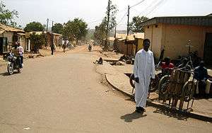
The Mbum were the earlier population of the surrounding area before the 19th-century invasion of the Fulani. The Fulani have ruled the area since the foundation of Ngaoundere in approximately 1835 in conjunction with the Mbum, who are considered a protected people according to Islamic law. The ruler is required to be descended from the ruling Fulani family on his father's side, extending back to the first Lamido of Ngaoundéré Ardo Njobdi of Boundang. On his mother's side, he is expected to be an Mbum descendent, so that he may represent the entirety of the population. Being the largest city in Adamawa by far, Ngaoundéré attracts numerous settlers from the surrounding rural areas, including Díi from further north, Gbaya from the Meiganga area, and Pere from the west. The population expanded greatly after completion of the railway in 1973, with a large percentage of the additional population originating from outside of Adamawa Region. This is evident in the ironic dichotomy between the so-called Grand Marché, adjacent to the Grand Mosqué and housing mainly local merchants, and the much larger Petit Marché located to the northwest in a neighborhood housing a population largely originating in the southern regions of Cameroon.
Climate
| Climate data for Ngaoundéré (1961–1990, extremes 1928–present) | |||||||||||||
|---|---|---|---|---|---|---|---|---|---|---|---|---|---|
| Month | Jan | Feb | Mar | Apr | May | Jun | Jul | Aug | Sep | Oct | Nov | Dec | Year |
| Record high °C (°F) | 36.0 (96.8) |
38.0 (100.4) |
39.0 (102.2) |
39.0 (102.2) |
38.0 (100.4) |
33.0 (91.4) |
37.4 (99.3) |
30.5 (86.9) |
32.0 (89.6) |
37.0 (98.6) |
35.0 (95) |
36.0 (96.8) |
39.0 (102.2) |
| Average high °C (°F) | 30.1 (86.2) |
31.6 (88.9) |
32.1 (89.8) |
30.6 (87.1) |
28.9 (84) |
27.4 (81.3) |
26.2 (79.2) |
26.2 (79.2) |
27.0 (80.6) |
28.5 (83.3) |
29.6 (85.3) |
30.0 (86) |
29.0 (84.2) |
| Daily mean °C (°F) | 20.5 (68.9) |
22.2 (72) |
24.1 (75.4) |
24.1 (75.4) |
23.1 (73.6) |
22.1 (71.8) |
21.5 (70.7) |
21.5 (70.7) |
21.7 (71.1) |
22.1 (71.8) |
20.9 (69.6) |
20.4 (68.7) |
22.0 (71.6) |
| Average low °C (°F) | 10.9 (51.6) |
12.8 (55) |
16.1 (61) |
17.7 (63.9) |
17.4 (63.3) |
16.9 (62.4) |
16.7 (62.1) |
16.8 (62.2) |
16.4 (61.5) |
15.8 (60.4) |
13.6 (56.5) |
10.7 (51.3) |
15.2 (59.4) |
| Record low °C (°F) | 4.0 (39.2) |
7.0 (44.6) |
8.3 (46.9) |
12.5 (54.5) |
11.0 (51.8) |
11.0 (51.8) |
11.5 (52.7) |
12.0 (53.6) |
12.0 (53.6) |
9.2 (48.6) |
6.7 (44.1) |
6.0 (42.8) |
4.0 (39.2) |
| Average precipitation mm (inches) | 0.8 (0.031) |
1.1 (0.043) |
39.2 (1.543) |
136.6 (5.378) |
183.9 (7.24) |
226.6 (8.921) |
268.6 (10.575) |
279.6 (11.008) |
236.9 (9.327) |
117.7 (4.634) |
5.7 (0.224) |
0.0 (0) |
1,496.7 (58.925) |
| Average precipitation days (≥ 1.0 mm) | 0 | 0 | 4 | 14 | 19 | 21 | 24 | 23 | 23 | 15 | 1 | 0 | 144 |
| Average relative humidity (%) | 33 | 30 | 44 | 72 | 77 | 81 | 83 | 82 | 81 | 75 | 55 | 47 | 63 |
| Mean monthly sunshine hours | 286.4 | 258.7 | 235.4 | 195.5 | 195.4 | 165.7 | 128.0 | 127.8 | 139.0 | 184.0 | 264.1 | 291.4 | 2,471.4 |
| Source #1: NOAA,[2] Meteo Climat (record highs and lows)[3] | |||||||||||||
| Source #2: Deutscher Wetterdienst (humidity, 1954–1967)[4] | |||||||||||||
Communications
The city serves as an important communications hub, linking the south of Cameroon with the northern part of the country.
Rail
The railway from Yaoundé ends here, and the railway station is always sprawling with life. An extension of this railway 700 km to Chad was approved in 2015.[5]
Road
There is a paved road of good standard, albeit with some potholes, extending from Ngaoundéré to Garoua and Maroua, and Chad. The main goods are bananas, fruits and general goods from the south. The north sends cotton stemming from Nord and Chad and cattle from Adamaoua towards the south.
Air
The airport has a 1.6 km strip, capable of accepting Boeing 737 and similar aircraft. In the 1980s and early 1990s, the airport had several flights a week to both Yaoundé and Douala in the south, Garoua in the north, and N'Djamena, Chad. Because of economic decline and the decline of the national carrier, Cameroon Airlines, the airport currently sees very little traffic, if any. The airports ICAO code is FKKN while the IATA code is NGE.
Radio
Ngaoundéré is linked to the Cameroonian microwave network, but the system is not very reliable. However, many private companies have two-way satellite communications, and there are many cybercafés in the city.
Mining
There are bauxite deposits in the vicinity.[6]
Religion
The city has a mixture of numerous religions. About 60% are Muslims; most are rather pragmatic with regards to religious observancy. Another 30% are Christians of various denominations, including Lutheran Protestant, Catholic, Baptist and Anglican. There has traditionally been few problems between the various religions, but a radicalization of Islam does seem to have taken place during the last decade. Married women in the area have traditionally worn a cloth over their hair (irrespective of religion), but garments like Hijab were previously almost unknown. Some Muslim women now choose to wear the hijab, but other Muslim dresses like the burqa are unknown.
Ngaoundéré is a diocese in the Catholic Church. The current bishop is Joseph Djida.
Missionaries
The Norwegian Missionary Society first established a mission here in the early 1920s. The church built in 1923 still stands. At the time of construction, there were three Christians in the city, but being optimistic, the church was built for a capacity of roughly 200. In cooperation with the local Evangelical Lutheran Church of Cameroon EELC and the American ELCA the NMS has built the Protestant Hospital of Ngaoundéré, a high school and several other institutions.
Ngaoundéré once held one of the largest Norwegian contingencies of any place in the world, with over 100 Norwegians living there in the 1980s. The neighbourhood was even dubbed "Norvège" ("Norway" in French).
The Catholic Church also has representatives and a large congregation in the area.
Statistics
- Population = approx 200,000 (2005 est.)
See also
References
- ↑
 Rines, George Edwin, ed. (1920). "Flegel, Eduard Robert". Encyclopedia Americana.
 - ↑ "Ngaoundéré Climate Normals 1961–1990". National Oceanic and Atmospheric Administration. Retrieved March 8, 2015.
- ↑ "Station Ngaoundéré" (in French). Meteo Climat. Retrieved 13 June 2016.
- ↑ "Klimatafel von Ngaounderé / Kamerun" (PDF). Baseline climate means (1961-1990) from stations all over the world (in German). Deutscher Wetterdienst. Retrieved 13 June 2016.
- ↑ Cameroon-Chad railway
- ↑ African Business December 2009, p62
External links
| Wikimedia Commons has media related to Ngaoundéré. |