New York State Route 357
| ||||
|---|---|---|---|---|
|
Map of central New York with NY 357 highlighted in red | ||||
| Route information | ||||
| Maintained by NYSDOT | ||||
| Length: | 14.06 mi[1] (22.63 km) | |||
| Existed: | January 1, 1970[2] – present | |||
| Major junctions | ||||
| West end: |
| |||
|
| ||||
| East end: |
| |||
| Location | ||||
| Counties: | Otsego, Delaware | |||
| Highway system | ||||
| ||||

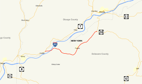
New York State Route 357 (NY 357) is a state highway in New York, running from the Otsego County village of Unadilla to the Delaware County town of Franklin.
NY 357 is only briefly in Otsego County, crossing the Susquehanna River as it enters Delaware County for its duration. After passing through the village of Franklin, it ends at NY 28 south of Oneonta.
Route description

NY 357 begins at NY 7 in the Otsego County village of Unadilla. As it exits Unadilla to the east, it immediately crosses the Susquehanna River and enters Delaware County.[3] Officially, only 210 feet (64 m) of NY 357's 14.06-mile (22.63 km) long routing is located within Otsego County.[1] Now in the town of Sidney, NY 357 intersects Interstate 88 (I-88) at exit 11 as it parallels Ouleout Creek eastward through the town. At the Sidney–Franklin town line, the route travels just south of the East Sidney Lake Recreation Area, a park surrounding the man-made East Sidney Lake. In Franklin, the route intersects with County Route 21 (CR 21), a connector leading south to Walton, as it turns north to serve the village of Franklin. From here, NY 357 progresses northeastward along the Ouleout Creek and intersects CR 14 in the hamlet of Leonta before reaching its eastern terminus at NY 28 in an area known as North Franklin.[3]
History
All of NY 357 was originally designated as part of NY 7B as part of the 1930 renumbering. North of North Franklin, NY 7B continued to NY 7 in Oneonta by way of an overlap with NY 28.[4] On November 27, 1969, the New York State Department of Transportation Commissioner T. W. Parker announced that NY 7B would be renumbered to NY 357 effective January 1. 1970. This new designation would also truncate NY 7B off the overlap with NY 28 to Oneonta and simply signage for drivers to understand in the city. This would also open the door for signage to be added for future Interstate 88 If the weather permitted, the official signage would be replaced in the spring of 1970.[5] On January 1, 1970, NY 7B was truncated southward to the southern terminus of its overlap with NY 28 and renumbered to NY 357.[2]
Major intersections
| County | Location | mi[1] | km | Destinations | Notes |
|---|---|---|---|---|---|
| Otsego | Village of Unadilla | 0.00 | 0.00 | ||
| Delaware | Town of Sidney | 1.03 | 1.66 | Exit 11 (I-88) | |
| Town of Franklin | 14.06 | 22.63 | |||
| 1.000 mi = 1.609 km; 1.000 km = 0.621 mi | |||||
See also
.svg.png) New York Roads portal
New York Roads portal
References
- 1 2 3 "2008 Traffic Volume Report for New York State" (PDF). New York State Department of Transportation. June 16, 2009. pp. 218–219. Retrieved February 1, 2010.
- 1 2 State of New York Department of Transportation (January 1, 1970). Official Description of Touring Routes in New York State (PDF). Retrieved January 3, 2010.
- 1 2 Google (April 19, 2008). "New York State Route 357" (Map). Google Maps. Google. Retrieved April 19, 2008.
- ↑ Automobile Legal Association (ALA) Automobile Green Book, 1930–31 and 1931–32 editions, (Scarborough Motor Guide Co., Boston, 1930 and 1931). The 1930–31 edition shows New York state routes prior to the 1930 renumbering
- ↑ "Route 7B Renamed; New Title Rt. 357". The Oneonta Star. November 28, 1969. Retrieved October 16, 2015 – via Newspapers.com.

External links
- New York State Route 357 at Alps' Roads • New York Routes • New York State Highway Termini