Nagapattinam Port
Nagapattinam Port (nākappaṭṭinam, previously spelt Nagapatnam or Negapatam) is a port in the South Indian town of Nagapattinam in the Indian state of Tamil Nadu. It is a natural port located in the shores of Bay of Bengal. The port came to prominence during the period of Medieval Cholas (9th −12th century CE) and served as their important port for commerce and east bound naval expeditions.
Nagapattinam was settled by the Portuguese and, later, the Dutch under whom it served as the capital of Dutch Coromandel from 1660 to 1781 CE. In November 1781, the town was conquered by the British East India Company. The port was an important port for the colonial empires until Thoothukudi port became the primary port in the Coramandel.
History
The port came to prominence during the period of Medieval Cholas (9th −12th century CE) and served as their important port for commerce and east bound naval expeditions.
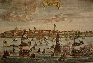
In the early 16th century the Portuguese started commercial contacts with the town through the port and established a commercial centre in 1554 CE. The Portuguese also conducted missionary enterprise in the town.[1] In 1658, the Dutch established an agreement between King Vijaya Nayakkar of Thanjavur on 5 January 1662. Ten villages were transferred from the Portuguese to the Dutch – Nagapattinam Port, Puthur, Muttam, Poruvalancheri, Anthanappettai, Karureppankadu, AzhingiMangalam, Sangamangalam, Thiruthinamangalam, Manjakollai, Nariyankudi. As per agreement between the first Maratta King Egoji of Thanjavur and the Dutch, Naagapattinam and surrounding villages were handed over to the Dutch on 30 December 1676. In 1690, the capital of Dutch Coromandel changed from Pulicat to Nagapattinam.[1]
This town fell into the hands of the British in 1781 after the two naval battles between British and French fleets were fought off the coast of Negapatam, as it was then known: the first in 1758 as part of the Seven Years' War and the second in 1782 as part of the American Revolutionary War. The town was taken by the British from the Dutch in 1781 (who had been formally brought into the war in 1780).[2] When the Dutch and British reached a peace agreement in 1784, Nagapattinam was formally ceded to the British. 277 villages with Nagore as the headquarters were handed over to the East India Company.
From 1799 to 1845 CE Nagapttinam was the headquarters of Tanjore district.[3] The town remained one of the chief ports to the Madras Presidency. The port suffered decline after the inclusion of Tranquebar and Tuticorin ports. The port was one of the ports severely affected by the tsunami which followed the 2004 Indian Ocean earthquake.[4][5][6][7]
Location
The port of Nagapattinam is located in Bay of Bengal in the mouth of river Kuduvayyar.[8]
Commercial activities
Nagapattinam was the most important port of the Chola empire. All the eastern naval expeditions of Rajendra Chola I (1012–44 CE) were through the port. The port was also widely used by the Dutch, Portuguese and British as one of the major ports in Coramandel Coast for trading purposes.[8] Most of the principal exports to Sri Lanka from the port during the British period were rice, piece goods, live stock, cigars, tobacco and skin. The trade of Nagapattinam was mostly with Sri Lanka, Straits Settlements, Burma and to a small extent to the United Kingdom and Spain.[9] The port also served passenger traffic to Singapore, but was susepended due to a fire accident.[10] The modern day port has a commercial port complex and a dockyard that are protected by a river mouth sand bar facing the port.[11] The port handles only limited amount of edible oil imports.[10] The Nagapttinam lighthouse is the first conventional 20-metre-high (66 ft) lighthouse tower built inside the port premises by the British in 1869.[12] The port and the lighthouse are maintained by the Tamil Nadu Maritime Board under the Government of India.[8]
Notes
- 1 2 W. 2002, p. 139.
- ↑ W. 2002, p. 136.
- ↑ W. 2002, p. 161.
- ↑ About the town 2011.
- ↑ Nagapattinam Municipality features 2011.
- ↑ Nagapattinam district profile 2011.
- ↑ Nagapattinam district local administration 2011.
- 1 2 3 Nagapattinam Port 2011.
- ↑ W. 2002, p. 144.
- 1 2 The Hindu Business Line 20 January 2012.
- ↑ Strand 2008, pp. 235–239.
- ↑ W. 2002, p. 162.
References
- "Nagapattinam in TN to be upgraded as all-weather, deep-water port". The Hindu Business Line. 20 January 2012. Retrieved 26 June 2012.
- "Nagapattinam in TN to be upgraded as all-weather, deep-water port". The Hindu Business Line. 20 January 2012. Retrieved 26 June 2012.
- "Nagapattinam district profile". Nagapattinam district administration. 2011. Retrieved 26 June 2012.
- "Nagapattinam district local administration". Nagapattinam district administration. 2011. Retrieved 26 June 2012.
- "Nagapattinam Port". Tamil Nadu Maritime Board. 2011. Retrieved 30 October 2012.
- "About the town". Nagapattinam Municipality, Government of Tamil Nadu. 2011. Retrieved 26 June 2012.
- "Salient Features of Nagapattinam Municipality". Nagapattinam Municipality, Government of Tamil Nadu. 2011. Retrieved 26 June 2012.
- W., Francis (2002). Gazetteer of South India, Volume 1. Mittal Publications.
- Strand, Carl Ludvig; John Paul Masek (2008), Sumatra-Andaman Islands Earthquake and Tsunami of December 26, 2004, USA: American Society of Civil Engineers, ISBN 978-0-7844-0951-0 Cite uses deprecated parameter
|coauthors=(help).