Nagorno-Karabakh Autonomous Oblast
| Nagorno-Karabakh Autonomous Oblast | ||||||
| Autonomous oblast of Azerbaijan Soviet Socialist Republic | ||||||
| ||||||
| ||||||
 | ||||||
| Capital | Stepanakert | |||||
| Government | Autonomous Oblast | |||||
| History | ||||||
| • | Established | July 7, 1923 | ||||
| • | Independence | November 26, 1991 | ||||
| Area | 4,388 km2 (1,694 sq mi) | |||||
| Population | ||||||
| • | 162,181 | |||||
| Density | 37 /km2 (95.7 /sq mi) | |||||
| Population source:[1] | ||||||
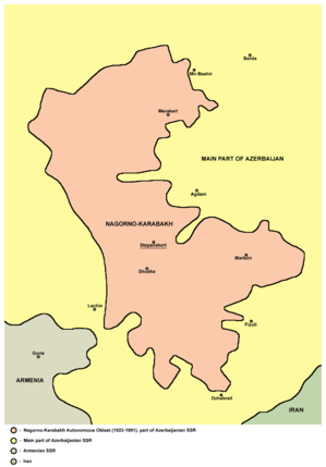
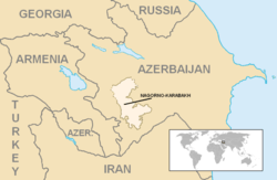
The Nagorno-Karabakh Autonomous Oblast (Russian: Нагорно-Карабахская автономная область, НКАО; Azerbaijani: Дағлыг Гарабағ Мухтар Вилајәти, ДГМВ, Dağlıq Qarabağ Muxtar Vilayəti, DQMV; Armenian: Լեռնային Ղարաբաղի Ինքնավար Մարզ, ԼՂԻՄ Lernayin Ġarabaġi Inknavar Marz, LĠIM) was an autonomous oblast within the borders of the Azerbaijan Soviet Socialist Republic, mostly inhabited by ethnic Armenians. According to Robert Service, in 1921 Joseph Stalin, then acting Commissar of Nationalities for the Soviet Union, included Nakhichevan Autonomous Soviet Socialist Republic and Karabakh under Azerbaijani control to try to placate Turkey to join the Soviet Union. Had Turkey not been an issue, Stalin would probably have left Karabakh under Armenian control.[2] As a result, the Nagorno-Karabakh Autonomous Oblast was established with the Azerbaijan Soviet Socialist Republic on July 7, 1923. According to Karl R. DeRouen it was created as an enclave so that a narrow strip of land would separate it from Armenia proper.[3] According to Audrey L. Altstadt, the borders of the oblast were drawn to include Armenian villages and to exclude as much as possible Azerbaijani villages, so that the resulting area was sure to have an Armenian majority.[4]
Military conflict
The Nagorno-Karabakh conflict between the Armenians in Nagorno Karabakh and Azerbaijan SSR of the Soviet Union broke out in 1987, and the fighting had grown into a full-scale war by the end of 1991. On November 26, 1991, the Parliament of the Azerbaijan SSR abolished the autonomous status of the NKAO. Its internal administrative divisions were also abolished, and its territory was split up and redistributed amongst the neighboring administrative rayons of Khojavend, Tartar, Goranboy, Shusha, and Kalbajar[5] In response, the majority Armenian population of the oblast unilaterally declared their independence as the Nagorno-Karabakh Republic. Most of territory of the former Nagorno-Karabakh Autonomous Oblast is under the control of the ethnic Armenian forces of Nagorno-Karabakh as a result of the Nagorno-Karabakh War. When the Soviet Union dissolved, the Nagorno-Karabakh region was reaffirmed by the United Nations Security Council Resolutions 822, 853, 874, and 884 as part of the newly independent Republic of Azerbaijan. Today, the area of the former NKAO includes the de facto established Nagorno-Karabakh Republic, although it is not recognized by any state or international government organization, and is de jure part of Azerbaijan.[6]
Law on Abolishment of Nagorno-Karabakh Autonomous Oblast
The NKAO was dissolved as an entity of Azerbaijan by the Law on Abolishment of Nagorno-Karabakh Autonomous Oblast.
Administrative divisions
- Mardakert District (NKAO)
- Martuni District (NKAO)
- Shusha District (NKAO)
- Askeran District (NKAO)
- Hadrut District (NKAO)
See also
References
- ↑ (Russian) НАГОРНО-КАРАБАХСКАЯ АО (1979 г.)
- ↑ Robert Service, Stalin: a Biography (Cambridge: Harvard University Press, 2006, ISBN 0-674-02258-0), p. 204
- ↑ Karl R. DeRouen, Civil Wars of the World: major conflicts since World War II, Vol. 1 (2007), p. 146
- ↑ Audrey L. Altstadt, The Azerbaijani Turks: power and identity under Russian rule (Hoover Press, 1992, ISBN 0-8179-9182-4, ISBN 978-0-8179-9182-1)
- ↑ Svante Cornell, Turkey and the Conflict in Nagorno Karabakh: A Delicate Balance, in Middle Eastern Studies Journal Vol 34, No. 1 (London: Frank Cass Publications, January 1998), pp. 51–72
- ↑ 1993 UN Security Council Resolutions on Nagorno-Karabakh, U.S. State Department website, accessed February 2007
External links
Coordinates: 39°48′55″N 46°45′07″E / 39.8153°N 46.7519°E
