Nain Singh Rawat
| Nain Singh Rawat | |
|---|---|
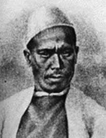 The (explorer) cartographer Nain Singh Rawat (19th century) received a Royal Geographical Society gold medal in 1876. | |
| Born | 1830 |
| Died | 1895 |
| Nationality | Indian |
| Occupation | Asian explorer |
| Religion | Hindu |
Nain Singh Rawat (Hindi: नैन सिंह रावत), 1830–1895, was one of the first of the late 19th century pundits who explored the Himalayas for the British. He hailed from the Johar Valley of Kumaon. He mapped the trade route through Nepal to Tibet, determined for the first time the location and altitude of Lhasa, and mapped a large section of the Tsangpo, the major Tibetan river.
Life and career
Rai Bahadur Nain Singh Rawat was born to Lata Burha in 1830 in Milam village, a Bhotia village in the valley of Johar, at the foot of the Milam glacier where the river Goriganga originates. The Rawats ruled over the Johar valley, during the reign of Chand dynasty in Kumaon; this was followed by the Gorkha rule. In 1816 the British defeated the Gorkhas but maintained a policy of non-interference and friendship towards the Johar Bhotias. The famous Bhotia explorers mostly belong to the village of Johar.
After leaving school, Nain Singh helped his father. He visited different centres in Tibet with him, learned the Tibetan language, customs and manners and became familiar with the Tibetan people. This knowledge of Tibetan language and local customs and protocol came handy in Nain Singh's work as "Spy Explorer". Due to the extreme cold conditions, Milam and other villages of the upper Johar valley are inhabited only for a few months from June to October. During this time the men used to visit Gya'nyima, Gartok and other markets in Western Tibet.
Each Indian trader of Johar, had a 'mitra' or colleague in Tibet. Initially, the splitting of a stone, each keeping one half, marked their partnership in trade. Henceforth, the Indian trader or his representative would carry the token to sell his goods in Tibet market only to his mitra's representative who would fit his half of the stone to the Indian's.
In 1855, Nain Singh Rawat, now a well-disposed and intelligent man of 25 years, of traditional Bhotia stature – short, stocky and stubborn – was first recruited by German geographers the Schlagintweit brothers. Baron Humboldt had sent these German scientists to the office of the Survey of India, which reluctantly allowed them to proceed with their survey.
Adolf and Robert Schlagintweit had met Deb Singh Rawat in the Johar valley, who showed them a thanks chit signed by William Moorecroft and inscribed 'Northern foot of the Himanchal Mountains near Daba in Chinese Tartary, 25 August 1812.' On his advice they recruited three members of his family for their expedition: Mani Singh Rawat, Dolpa and Nain Singh Rawat. Nain Singh’s first exploration trip was with the Germans between 1855 and 1857. He travelled to Lakes Manasarovar and Rakas Tal and then further to Gartok and Ladakh.
After the exploration with the Schlagintweit brothers, Nain Singh Rawat joined the Education Department, being appointed as the headmaster of a government vernacular school in his village at Milam from 1858 to 1863.
In 1863, Nain Singh Rawat and his cousin, Mani Singh Rawat, were sent to the Great Trignometric Survey office in Dehradun where they underwent training for two years. This included training on the use of scientific instruments and ingenious ways of measuring and recording and the art of disguise. Nain Singh Rawat was exceptionally intelligent and quickly learned the correct use of scientific instruments like the sextant and compass. He could recognise all major stars and different constellations easily. This was possible due to exhaustive practice and a drive and determination in the hand-picked men.
A sergeant major drilled them using a pace-stick, to take steps of a fixed length which remained constant even while climbing up, down, or walking on a level surface. They were trained to record the distances by an ingenious method using a modified Buddhist rosary or mala. This rosary, unlike a Hindu or Buddhist one, which has 108 beads, had 100. Every 100 steps the explorer would slip one bead, so a complete length of the rosary represented 10,000 steps. It was easy to calculate the distance as each step was 31½ inches and a mile was calculated to be around 2,000 steps. To avoid suspicion, these explorers went about their task disguised as monks or traders or whatever suited the situation. Many more ingenious methods were devised. The notes of measurements were coded in the form of written prayers, and these scrolls of paper were hidden in the cylinder of the prayer wheel.
The explorers kept this secret log book up to date. A compass for taking bearings was hidden in the lid of the prayer wheel. Mercury, used for creating an artificial horizon, was kept in cowrie shells and, for use, poured into the begging bowl carried by the pundit. A thermometer was in the topmost part of the monk's staff. There were workshops, where false bottoms were made in provisions chests to hold sextants and other surveying instruments. Hidden pockets were also added to the clothes worn during these secret missions.
Thus prepared and trained, the explorers travelled for months at a stretch, collecting intelligence under the most difficult conditions, travelling closely with the natives in caravans. What was to follow were some of the most glorious years in the exploration and mapping of Tibet and all its river systems and some of the most fascinating explorations.
In 1865–66, Nain Singh travelled 1200 miles from Kathmandu to Lhasa and thence to Lake Manasarovar and back to India. His last and greatest journey was from Leh in Ladhak via Lhasa to Assam in 1873–75. For his extraordinary achievements and contributions, Nain Singh was honoured with many awards by the Royal Geographical Society.
In 1865, with his cousin Mani Singh, Nain Singh left Dehra Dun, the Trigonometric Survey of India's northern India headquarters, for Nepal. From there Mani returned to India by way of western Tibet. Nain went on to Tashilhunpo, where he met the Panchen Lama, and Lhasa, where he met the Dalai Lama. During his stay in Lhasa, his true identity was discovered by two Kashmiri Muslim merchants residing there. Not only did they not report him to the authorities, they lent him a small sum of money against the pledge of his watch.[1][2] Nain Singh returned to India by way of Mansarowar Lake in western Tibet.
On a second voyage, in 1867, Singh explored western Tibet and visited the legendary Thok Jalung[3] gold mines. He noticed that the workers only dug for gold near the surface, because they believed digging deeper was a crime against the Earth and would deprive it of its fertility.[1][4]
In 1873–75, he travelled from Leh in Kashmir to Lhasa, by a route more northerly than the one along the Tsangpo that he had taken on his first journey.[1][5]
In recognition of his prodigious feats of exploration, regarding which Colonel Henry Yule commented that "his explorations have added a larger amount of important knowledge to the map of Asia than any other living man", Nain Singh was presented with an inscribed gold chronometer by the Royal Geographic Society (RGS) in 1868. This was followed by the award of the Victoria or Patron's Medal of the RGS in 1877. The Society of Geographers of Paris also awarded Nain Singh an inscribed watch. The Government of India bestowed two villages as a land-grant to him.[6]
Nain Singh Rawat died of a heart attack in 1895, while visiting his Jagir, a plains village granted to him by the British in 1877.
Legacy
On 27 June 2004, an Indian postage stamp featuring Nain Singh[7] was issued commemorating his role in the Great Trigonometric Survey.
In 2006 Drs. Shekhar Pathak and Uma Bhatt brought out a biography of Nain Singh with three of his diaries and the RGS articles about his travels in three volumes titled Asia ki Peeth Par published by Pahar, Naini Tal: a belated but fitting tribute to the man.
The life of Nain Singh Rawat paraphrases the entire struggle for power not only in the plains of India but through the crucial and strategic plateaus and valleys of Tibet, the high Himalaya and the Hindu Kush.
See also
- Kumauni People
- Shauka - Johar
- bhotia-Johar
- Krishna Singh Rawat
- Mani Singh Rawat
- List of explorers
- Cartography of India
References
- 1 2 3 Asia ki Peeth Par: Pandit Nain Singh Rawat ed. Uma Bhatt & Shekhar Pathak, Naini Tal, 2006
- ↑ "Report of a Route-Survey made by PUNDIT-----,&c." by T.G. Montgomerie, The Journal of the Royal Geographic Society, vol. 38, 1868
- ↑ Peter Hopkirk, Trespassers on the Roof of the World (Kindle Location 665). Hachette Littlehampton. Kindle Edition.
- ↑ "Report of the Trans-Himalayan Explorations during 1867" by T.G. Montgomerie, The Journal of the Royal Geographic Society, vol. 39, 1869
- ↑ "Account of the Pundit's Journey in Great Tibet &c" by Capt. H. Trotter, The Journal of the Royal Geographic Society, vol. 47, 1877
- ↑ Obituary notice of Nain Singh by Col. Edmund Smyth in Proceedings of The Royal Geographical Society &c,New Monthly Series, Vol.IV, 1882: p.315-317.
- ↑ Trigonometrical Survey