Napo Province
| Napo | ||
|---|---|---|
| Province | ||
| Province of Napo | ||
| ||
.svg.png) Location of Napo Province in Ecuador. | ||
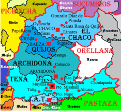 Cantons of Napo Province | ||
| Coordinates: 0°59′20″S 77°48′57″W / 0.9890°S 77.8159°WCoordinates: 0°59′20″S 77°48′57″W / 0.9890°S 77.8159°W | ||
| Country | Ecuador | |
| Established | October 22, 1959. | |
| Capital | Tena | |
| Cantons | List of Cantons | |
| Area | ||
| • Total | 12,542.50 km2 (4,842.69 sq mi) | |
| Population (2010 census) | ||
| • Total | 103,697 | |
| • Density | 8.3/km2 (21/sq mi) | |
| • Urban | 60,880 | |
| Time zone | ECT (UTC-5) | |
| Vehicle registration | N | |
| Website |
www | |
Napo is a province in Ecuador. Its capital is Tena. The province contains the Napo River. The province is low developed without much industrial presence. The thick rainforest is home to many natives that remain isolated by preference, descendants of those who fled the Spanish invasion in the Andes, and the Incas years before. In 2000, the province was the sole remaining majority-indigenous province of Ecuador, with 56.3% of the province either claiming indigenous identity or speaking an indigenous language.[1]
This province is one of the many located in Ecuador's section of the Amazon Rainforest.
In Napo province are also Antisana Ecological Reserve and Limoncocha National Biological Reserve.
Cantons
The province is divided into five cantons. The following table lists each with its population at the 2001 census, its area in square kilometres (km²), and the name of the canton seat or capital.[2]
| Canton | Pop. (2001) | Area (km²) | Seat/Capital |
|---|---|---|---|
| Archidona | 18,551 | 3,029 | Archidona |
| Carlos Julio Arosemena Tola | 2,943 | 501 | Carlos Julio Arosemena Tola |
| El Chaco | 6,133 | 3,473 | El Chaco |
| Quijos | 5,505 | 1,577 | Baeza |
| Tena | 46,007 | 3,904 | Tena |
See also
- Apostolic Vicariate of Napo, the coinciding Roman Catholic missionary circonscription
- Provinces of Ecuador
- Cantons of Ecuador
- A'i (Cofan) people
References
- ↑ Informe Social 2003. Retrieved July 30, 2011.
- ↑ Cantons of Ecuador. Statoids.com. Retrieved 4 November 2009.
Further reading
- Juncosa, Jose E. (ed.) (1997). Viajes por el Napo: cartas de un misionero (1924-1930). Quito: Abya-Yala. ISBN 9978042601
| Wikimedia Commons has media related to Province of Napo. |