National Park Mountain
| National Park Mountain | |
|---|---|
 National Park Mountain | |
| Highest point | |
| Elevation | 7,549 ft (2,301 m) [1] |
| Coordinates | 44°38′13″N 110°52′18″W / 44.63694°N 110.87167°WCoordinates: 44°38′13″N 110°52′18″W / 44.63694°N 110.87167°W [2] |
| Geography | |
| Location | Teton County, Wyoming, U.S. |
| Parent range | Yellowstone Plateau |
| Topo map | USGS Madison Junction |
| Climbing | |
| Easiest route | hike |
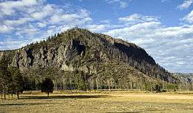
National Park Mountain (7,549 feet (2,301 m)) is in Yellowstone National Park in the U.S. state of Wyoming. National Park Mountain rises above the confluence of the Firehole River and the Madison River and is just west of Madison Junction.[3]
References
- ↑ "National Park Mountain, Wyoming". Peakbagger.com. Retrieved 2011-02-12.
- ↑ "National Park Mountain". Geographic Names Information System. United States Geological Survey. Retrieved 2011-02-12.
- ↑ "Madison Junction, WY" (Map). USGS Quad. TopoQuest. Retrieved 2011-02-12.
Yellowstone National Park - Norris and Madison | ||
|---|---|---|
Geothermal features, historic structures and other attractions in the Norris and Madison Junction areas | ||
| Norris Geyser Basin |  | |
| Gibbon Geyser Basin | ||
| Structures and History | ||
| Geography and Geology | ||
| ||
This article is issued from Wikipedia - version of the 11/1/2014. The text is available under the Creative Commons Attribution/Share Alike but additional terms may apply for the media files.