| [3] |
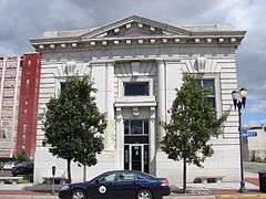
Name on the Register[4] |
Image |
Date listed[5] |
Location |
City or town |
Description |
|---|
| 1 |
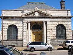
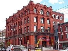
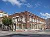
American National Bank |
|
000000001990-08-22-0000August 22, 1990
(#90001256) |
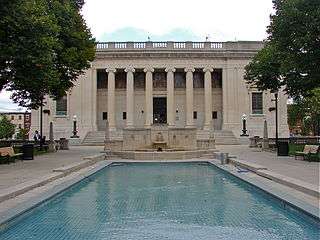
1219 Broadway
39°55′49″N 75°07′12″W / 39.930278°N 75.12°W / 39.930278; -75.12 (American National Bank) |
Camden |
|
| 2 |
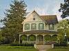
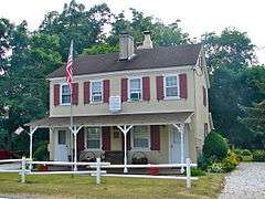
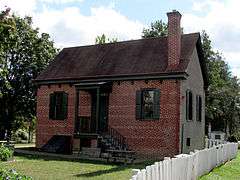
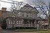
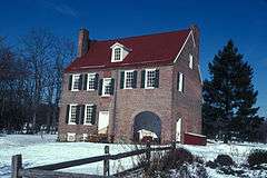
Barclay Farm House |
|
000000001978-01-26-0000January 26, 1978
(#78001753) |
Northeast of Haddonfield near the junction of Interstate 295 and Route 70
39°54′10″N 74°59′46″W / 39.902778°N 74.996111°W / 39.902778; -74.996111 (Barclay Farm House) |
Cherry Hill |
|
| 3 |
BARNEGAT (lightship) |
|
000000001979-11-29-0000November 29, 1979
(#79002317) |
North 7th Street
39°57′21″N 75°06′46″W / 39.955833°N 75.112778°W / 39.955833; -75.112778 (BARNEGAT (lightship)) |
Camden |
LV 79 / WAL 506; Was in Philadelphia
|
| 4 |
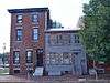
Volney G. Bennett Lumber Company |
|
000000001993-08-05-0000August 5, 1993
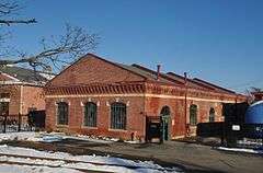
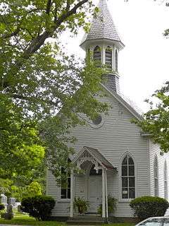
(#93000749) |
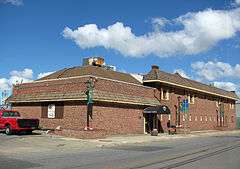
138 Division St. and 845 S. 2nd St.
39°56′05″N 75°07′43″W / 39.934722°N 75.128611°W / 39.934722; -75.128611 (Volney G. Bennett Lumber Company) |
Camden |
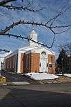
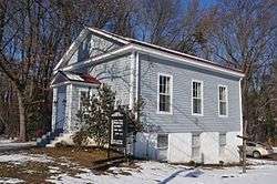
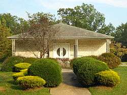
|
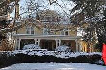
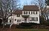
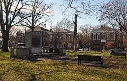
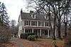
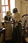
| 5 |
Berlin Historic District |
|
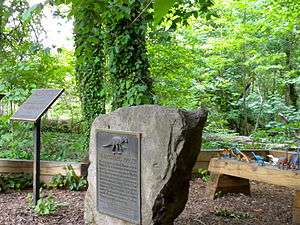
000000001995-04-14-0000April 14, 1995
(#95000408) |
Roughly along Washington, E. Taunton, and Haines Aves. and parts of S. White Horse Pike, Jackson Rd., and Jefferson Ave.
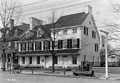
39°47′34″N 74°55′43″W / 39.792778°N 74.928611°W / 39.792778; -74.928611 (Berlin Historic District) |
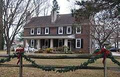
Berlin |
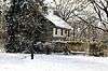
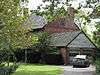
|
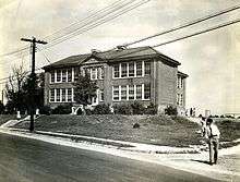
| 6 |
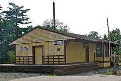
Blackwood Historic District |
|
000000001989-07-27-0000July 27, 1989
(#89000996) |
Roughly Church St. from E. Railroad Ave. to Indiana Ave., Blackhorse Pike, and Central Ave.
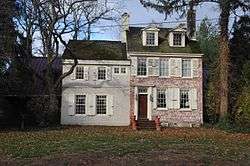
39°48′02″N 75°03′11″W / 39.800556°N 75.053056°W / 39.800556; -75.053056 (Blackwood Historic District) |
Blackwood |
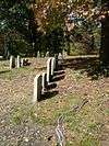
|
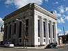
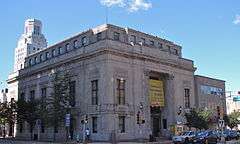
| 7 |
Bonnie's Bridge |
|
000000001984-09-13-0000September 13, 1984
(#84002604) |
350 Wayland Rd.
39°54′39″N 75°00′18″W / 39.910833°N 75.005°W / 39.910833; -75.005 (Bonnie's Bridge) |
Cherry Hill |
|
| 8 |
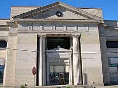
Broadway Trust Company |
|
000000001990-08-24-0000August 24, 1990
(#90001284) |
938-944 Broadway
39°56′02″N 75°07′11″W / 39.933889°N 75.119722°W / 39.933889; -75.119722 (Broadway Trust Company) |
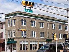
Camden |
|
| 9 |
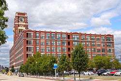
Building 17, RCA Victor Company, Camden Plant |
|
000000002002-10-04-0000October 4, 2002
(#02001253) |
1 Market St.
39°56′51″N 75°07′38″W / 39.9475°N 75.127222°W / 39.9475; -75.127222 (Building 17, RCA Victor Company, Camden Plant) |
Camden |
|
| 10 |
Building at 525 Cooper Street |
|
000000001990-08-24-0000August 24, 1990
(#90001286) |
525 Cooper St.
39°56′48″N 75°07′14″W / 39.946667°N 75.120556°W / 39.946667; -75.120556 (Building at 525 Cooper Street) |
Camden |
|
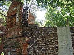
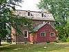
| 11 |
Burrough-Dover House |
|
000000001973-10-25-0000October 25, 1973
(#73001089) |
9201 Burrough-Dover Lane (off Haddonfield Rd.)
39°58′24″N 75°01′05″W / 39.973333°N 75.018056°W / 39.973333; -75.018056 (Burrough-Dover House) |
Pennsauken Township |
|
| 12 |
Camden Fire Insurance Association |
|
000000001990-08-22-0000August 22, 1990
(#90001262) |
428-432 Federal St.
39°56′38″N 75°07′20″W / 39.943889°N 75.122222°W / 39.943889; -75.122222 (Camden Fire Insurance Association) |
Camden |
Demolished.[6]
|
| 13 |
Camden Free Public Library Main Building |
|
000000001992-10-15-0000October 15, 1992
(#92001385) |
616 Broadway
39°56′14″N 75°07′06″W / 39.937222°N 75.118333°W / 39.937222; -75.118333 (Camden Free Public Library Main Building) |
Camden |
|
| 14 |
Camden Safe Deposit & Trust Company |
|
000000001990-08-22-0000August 22, 1990
(#90001258) |
Market St. and Broadway
39°56′43″N 75°07′09″W / 39.945278°N 75.119167°W / 39.945278; -75.119167 (Camden Safe Deposit & Trust Company) |
Camden |
|
| 15 |
Cattell Tract Historic District |
|
000000001994-09-08-0000September 8, 1994
(#94001103) |
Roughly bounded by N. Chestnut Ave., Cove Rd., and Rogers and Leslie Aves.
39°57′16″N 75°02′57″W / 39.954444°N 75.049167°W / 39.954444; -75.049167 (Cattell Tract Historic District) |
Merchantville |
|
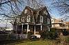
| 16 |
Centennial House |
|
000000001991-05-30-0000May 30, 1991
(#91000674) |
17-19 E. Chestnut Ave.
39°57′10″N 75°02′56″W / 39.952778°N 75.048889°W / 39.952778; -75.048889 (Centennial House) |
Merchantville |
|
| 17 |
Central Trust Company |
|
000000002005-01-05-0000January 5, 2005
(#90001253) |
401 Federal St.
39°56′39″N 75°07′24″W / 39.944167°N 75.123333°W / 39.944167; -75.123333 (Central Trust Company) |
Camden |
|
| 18 |
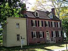
Chew-Powell House |
|
000000001975-03-27-0000March 27, 1975
(#75001127) |
500-502 Good Intent Rd.
39°48′23″N 75°04′33″W / 39.806389°N 75.075833°W / 39.806389; -75.075833 (Chew-Powell House) |
Gloucester Township |
|
| 19 |
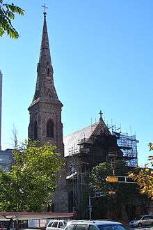
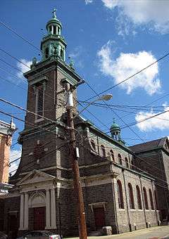
Church of the Immaculate Conception |
|
000000002003-12-10-0000December 10, 2003
(#03001277) |
642 Market St.
39°56′41″N 75°07′08″W / 39.944722°N 75.118889°W / 39.944722; -75.118889 (Church of the Immaculate Conception) |
Camden |
|
| 20 |
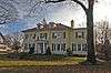
Samuel Coles House |
|
000000001973-06-18-0000June 18, 1973
(#73001087) |
1743 Old Cuthbert Rd.
39°54′49″N 74°58′41″W / 39.913611°N 74.978056°W / 39.913611; -74.978056 (Samuel Coles House) |
Cherry Hill |
|
| 21 |
Collings-Knight Homestead |
|
000000001987-09-10-0000September 10, 1987
(#87001518) |
500 Collings Ave.
39°54′42″N 75°04′52″W / 39.911667°N 75.081111°W / 39.911667; -75.081111 (Collings-Knight Homestead) |
Collingswood |
|
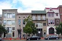
| 22 |
Collingswood Commercial Historic District |
|
000000001990-09-13-0000September 13, 1990
(#90001439) |
Roughly Haddon Ave. between Woodlawn and Fern, including adjacent areas on Collings Ave.
39°54′57″N 75°04′06″W / 39.915833°N 75.068333°W / 39.915833; -75.068333 (Collingswood Commercial Historic District) |
Collingswood |
|
| 23 |
Collingswood Residential Historic District |
|
000000001990-09-13-0000September 13, 1990
(#90001436) |
Roughly Knight Park and its bordering properties, including Park Ave. east to Dayton Ave.
39°54′46″N 75°04′40″W / 39.912778°N 75.077778°W / 39.912778; -75.077778 (Collingswood Residential Historic District) |
Collingswood |
|
| 24 |
Collingswood Theatre |
|
000000001982-06-03-0000June 3, 1982
(#82003269) |
843 Haddon Ave.
39°54′57″N 75°03′58″W / 39.915833°N 75.066111°W / 39.915833; -75.066111 (Collingswood Theatre) |
Collingswood |
|
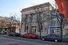
| 25 |
Collins and Pancoast Hall |
|
000000001984-02-16-0000February 16, 1984
(#84002608) |
4-8 S. Centre St.
39°57′07″N 75°02′59″W / 39.951944°N 75.049722°W / 39.951944; -75.049722 (Collins and Pancoast Hall) |
Merchantville |
|
| 26 |
Cooper Grant Historic District |
|
000000001989-01-30-0000January 30, 1989
(#87002229) |
Point, N. Front, Linden, Penn, and N. 2nd Sts.
Boundary increase: 300 N. Delaware Ave.
39°56′58″N 75°07′32″W / 39.949444°N 75.125556°W / 39.949444; -75.125556 (Cooper Grant Historic District) |
Camden |
|
| 27 |
Cooper Library in Johnson Park |
|
000000001980-03-11-0000March 11, 1980
(#80002473) |
2nd and Cooper Sts.
39°56′53″N 75°07′31″W / 39.948056°N 75.125278°W / 39.948056; -75.125278 (Cooper Library in Johnson Park) |
Camden |
|
| 28 |
Cooper River Park Historic District |
|
000000002016-07-19-0000July 19, 2016
(#16000456) |
Roughly bounded by Kaighn, Roberts, Glover & Narbeth Aves., N. Park, S. Edge Park & S. Park Drs., Kings Hwy.
39°55′33″N 75°05′02″W / 39.925953°N 75.083820°W / 39.925953; -75.083820 (Cooper River Park Historic District) |
Collingswood |
|
| 29 |
Cooper Street Historic District |
|
000000001989-08-07-0000August 7, 1989
(#89001057) |
Cooper St. from 2nd to 7th Sts.
39°56′49″N 75°07′17″W / 39.946944°N 75.121389°W / 39.946944; -75.121389 (Cooper Street Historic District) |
Camden |
|
| 30 |
Joseph Cooper House |
|
000000001973-03-14-0000March 14, 1973
(#73001086) |
Head of 7th St. in Pyne Point Park
39°57′16″N 75°06′57″W / 39.954444°N 75.115833°W / 39.954444; -75.115833 (Joseph Cooper House) |
Camden |
|
| 31 |
Arthur Dorrance House |
|
000000001994-05-13-0000May 13, 1994
(#94000391) |
28 Franklin Ave.
39°57′05″N 75°02′49″W / 39.951389°N 75.046944°W / 39.951389; -75.046944 (Arthur Dorrance House) |
Merchantville |
|
| 32 |
James M. Downey Building |
|
000000001990-08-22-0000August 22, 1990
(#90001261) |
521 Cooper St.
39°56′16″N 75°07′14″W / 39.937778°N 75.120556°W / 39.937778; -75.120556 (James M. Downey Building) |
Camden |
|
| 33 |
East End Trust Company |
|
000000001990-08-22-0000August 22, 1990
(#90001254) |
2614-2616 Federal St.
39°56′46″N 75°05′19″W / 39.946111°N 75.088611°W / 39.946111; -75.088611 (East End Trust Company) |
Camden |
|
| 34 |
Col. Joseph Ellis House |
|
000000001994-09-23-0000September 23, 1994
(#94001110) |
1009 Sycamore St.
39°52′36″N 75°03′48″W / 39.876667°N 75.063333°W / 39.876667; -75.063333 (Col. Joseph Ellis House) |
Haddon Heights |
|
| 35 |
Fairview District |
|
000000001974-11-19-0000November 19, 1974
(#74001157) |
Roughly bounded by Newton Creek, Crescent Boulevard, Mt. Ephraim Ave., and Olympia and Hull Rds.
39°54′20″N 75°06′17″W / 39.905556°N 75.104722°W / 39.905556; -75.104722 (Fairview District) |
Camden |
|
| 36 |
Federal Building and Courthouse |
|
000000002012-01-04-0000January 4, 2012
(#11000992) |
401 Market St.
39°56′46″N 75°07′19″W / 39.946217°N 75.121872°W / 39.946217; -75.121872 (Federal Building and Courthouse) |
Camden |
|
| 37 |
Finance Building |
|
000000001990-08-22-0000August 22, 1990
(#90001260) |
549-559 Cooper St.
39°56′48″N 75°07′11″W / 39.946667°N 75.119722°W / 39.946667; -75.119722 (Finance Building) |
Camden |
Demolished.[7] Photo shows the replacement building.
|
| 38 |
First Camden National Bank & Trust |
|
000000001990-08-24-0000August 24, 1990
(#90001285) |
Junction of Broadway and Cooper St.
39°56′42″N 75°07′10″W / 39.945°N 75.119444°W / 39.945; -75.119444 (First Camden National Bank & Trust) |
Camden |
|
| 39 |
Gatehouse at Colestown Cemetery |
|
000000001975-05-21-0000May 21, 1975
(#75001128) |
Kings Highway and Church Rd.
39°56′00″N 74°59′24″W / 39.933333°N 74.99°W / 39.933333; -74.99 (Gatehouse at Colestown Cemetery) |
Cherry Hill |
|
| 40 |
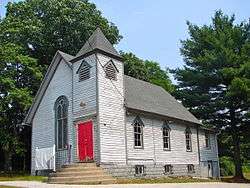
Glendale Methodist Episcopal Church |
|
000000001995-08-04-0000August 4, 1995
(#95001000) |
615 Haddonfield-Berlin Rd. (Route 561) at its junction with White Horse Rd.
39°51′14″N 74°58′58″W / 39.853889°N 74.982778°W / 39.853889; -74.982778 (Glendale Methodist Episcopal Church) |
Voorhees Township |
|
| 41 |
Gloucester City Water Works Engine House |
|
000000001998-03-30-0000March 30, 1998
(#98000235) |
Junction of Johnson Boulevard and Gaunt St.
39°53′47″N 75°06′53″W / 39.896389°N 75.114722°W / 39.896389; -75.114722 (Gloucester City Water Works Engine House) |
Gloucester City |
|
| 42 |
Glover Fulling Mill Site |
|
000000001990-09-28-0000September 28, 1990
(#90001452) |
Address Restricted
|
Haddon Heights |
|
| 43 |
Isaac Glover House |
|
000000001994-09-23-0000September 23, 1994
(#94001117) |
1908 New Jersey Ave.
39°52′49″N 75°04′53″W / 39.880278°N 75.081389°W / 39.880278; -75.081389 (Isaac Glover House) |
Haddon Heights |
|
| 44 |
Grant A.M.E. Church |
|
000000001977-10-05-0000October 5, 1977
(#77000857) |
4th and Washington Sts.
39°44′06″N 74°52′46″W / 39.735°N 74.879444°W / 39.735; -74.879444 (Grant A.M.E. Church) |
Chesilhurst |
Church built in 1896 and destroyed sometime after 1977. The photo shows its replacement.
|
| 45 |
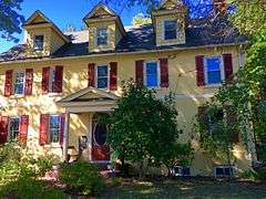
Greenfield Hall |
|
000000001974-06-05-0000June 5, 1974
(#74001158) |
343 Kings Highway, E.
39°54′01″N 75°05′11″W / 39.900278°N 75.086389°W / 39.900278; -75.086389 (Greenfield Hall) |
Haddonfield |
|
| 46 |
Haddon Fortnightly Club House |
|
000000001972-10-26-0000October 26, 1972
(#72000771) |
301 Kings Highway
39°53′59″N 75°01′45″W / 39.899722°N 75.029167°W / 39.899722; -75.029167 (Haddon Fortnightly Club House) |
Haddonfield |
|
| 47 |
Haddonfield Historic District |
|
000000001982-07-21-0000July 21, 1982
(#82003270) |
Roughly bounded by Washington, Hopkins, Summit, and E. Park Aves., and the Kings Highway
39°53′49″N 75°02′00″W / 39.896944°N 75.033333°W / 39.896944; -75.033333 (Haddonfield Historic District) |
Haddonfield |
|
| 48 |
Hadrosaurus Foulkii Leidy Site |
|
000000001994-10-12-0000October 12, 1994
(#94001648) |
End of Maple Ave. near the Cooper River
39°54′34″N 75°01′40″W / 39.909444°N 75.027778°W / 39.909444; -75.027778 (Hadrosaurus Foulkii Leidy Site) |
Haddonfield |
|
| 49 |
Hillman Hospital House |
|
000000001977-07-14-0000July 14, 1977
(#77000858) |
500 3rd Ave.
39°50′15″N 75°03′40″W / 39.8375°N 75.061111°W / 39.8375; -75.061111 (Hillman Hospital House) |
Glendora |
|
| 50 |
Hinchman-Lippincott House |
|
000000001995-02-17-0000February 17, 1995
(#94001121) |
1089 N. Park Ave.
39°52′48″N 75°04′01″W / 39.88°N 75.066944°W / 39.88; -75.066944 (Hinchman-Lippincott House) |
Haddon Heights |
|
| 51 |
Indian King Tavern |
|
000000001970-12-18-0000December 18, 1970
(#70000382) |
233 Kings Highway, E.
39°53′56″N 75°01′52″W / 39.898889°N 75.031111°W / 39.898889; -75.031111 (Indian King Tavern) |
Haddonfield |
|
| 52 |
Inter-County Mortgage and Finance Company |
|
000000001990-08-22-0000August 22, 1990
(#90001263) |
333 Arch St.
39°56′41″N 75°07′26″W / 39.944722°N 75.123889°W / 39.944722; -75.123889 (Inter-County Mortgage and Finance Company) |
Camden |
|
| 53 |
Kay-Evans Farm |
|
000000002000-06-28-0000June 28, 2000
(#00000693) |
100 Borton Mill Rd.
39°53′54″N 75°01′13″W / 39.898333°N 75.020278°W / 39.898333; -75.020278 (Kay-Evans Farm) |
Cherry Hill |
better known as the Croft Farm
|
| 54 |
Lawnside School |
|
000000002015-03-17-0000March 17, 2015
(#15000092) |
23 N. Warwick Rd.
39°52′06″N 75°02′04″W / 39.8682°N 75.0344°W / 39.8682; -75.0344 (Lawnside School) |
Lawnside Borough |
|
| 55 |
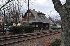
Long-A-Coming Depot |
|
000000001997-02-14-0000February 14, 1997
(#97000063) |
Between Washington and E. Taunton Aves., southeast of the junction of Route 73 and E. Taunton Ave.
39°47′38″N 74°55′34″W / 39.793889°N 74.926111°W / 39.793889; -74.926111 (Long-A-Coming Depot) |
Berlin |
|
| 56 |
Macedonia African Methodist Episcopal Church |
|
000000002012-03-12-0000March 12, 2012
(#12000108) |
261-265 Spruce St.
39°56′06″N 75°07′29″W / 39.93489°N 75.124685°W / 39.93489; -75.124685 (Macedonia African Methodist Episcopal Church) |
Camden |
|
| 57 |
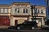
Marcouse Building |
|
000000001990-08-24-0000August 24, 1990
(#90001266) |
231 Market St.
39°56′47″N 75°07′28″W / 39.946389°N 75.124444°W / 39.946389; -75.124444 (Marcouse Building) |
Camden |
|
| 58 |
Robert Marshall House |
|
000000002008-01-16-0000January 16, 2008
(#07001402) |
510 Almonesson Rd.
39°48′44″N 75°04′50″W / 39.812219°N 75.080644°W / 39.812219; -75.080644 (Robert Marshall House) |
Gloucester Township |
|
| 59 |
Samuel Mickle House |
|
000000001975-05-21-0000May 21, 1975
(#75001129) |
345 Kings Highway, E.
39°54′01″N 75°01′41″W / 39.900278°N 75.028056°W / 39.900278; -75.028056 (Samuel Mickle House) |
Haddonfield |
|
| 60 |
Griffith Morgan House |
|
000000001973-01-25-0000January 25, 1973
(#73001088) |
234 Griffith Morgan Lane (off River Road)
39°59′24″N 75°02′55″W / 39.99°N 75.048611°W / 39.99; -75.048611 (Griffith Morgan House) |
Pennsauken Township |
|
| 61 |
Peter Mott House |
|
000000001994-09-08-0000September 8, 1994
(#94001101) |
Junction of Moore and Gloucester Aves.
39°52′02″N 75°02′10″W / 39.867222°N 75.036111°W / 39.867222; -75.036111 (Peter Mott House) |
Lawnside |
|
| 62 |
Mount Peace Cemetery and Funeral Directing Company Cemetery |
|
000000002009-07-29-0000July 29, 2009
(#08000971) |
329 U.S. Route 30
39°52′13″N 75°02′35″W / 39.870297°N 75.0431°W / 39.870297; -75.0431 (Mount Peace Cemetery and Funeral Directing Company Cemetery) |
Lawnside |
|
| 63 |
National State Bank |
|
000000001990-08-24-0000August 24, 1990
(#90001267) |
123 Market St.
39°56′47″N 75°07′34″W / 39.946389°N 75.126111°W / 39.946389; -75.126111 (National State Bank) |
Camden |
|
| 64 |
New Jersey Safe Deposit and Trust Company |
|
000000001990-08-24-0000August 24, 1990
(#90001265) |
Market and 3rd Sts.
39°56′47″N 75°07′40″W / 39.946389°N 75.127778°W / 39.946389; -75.127778 (New Jersey Safe Deposit and Trust Company) |
Camden |
|
| 65 |
Newton Friends' Meetinghouse |
|
000000001971-08-12-0000August 12, 1971
(#71000498) |
722 Cooper St.
39°56′45″N 75°07′01″W / 39.945833°N 75.116944°W / 39.945833; -75.116944 (Newton Friends' Meetinghouse) |
Camden |
|
| 66 |
Newton Union Schoolhouse |
|
000000001988-10-27-0000October 27, 1988
(#88002122) |
Collings and Lynne Aves.
39°54′31″N 75°05′30″W / 39.908611°N 75.091667°W / 39.908611; -75.091667 (Newton Union Schoolhouse) |
Haddon Township |
|
| 67 |
The Oaks Historic District |
|
000000001997-07-09-0000July 9, 1997
(#97000772) |
Roughly bounded by W. Maple Ave., Browning Rd., Volan St., and Oak Terrace
39°56′55″N 75°03′32″W / 39.948611°N 75.058889°W / 39.948611; -75.058889 (The Oaks Historic District) |
Merchantville |
|
| 68 |
Pomona Hall |
|
000000001971-08-12-0000August 12, 1971
(#71000499) |
Park Boulevard and Euclid Ave.
39°55′51″N 75°05′40″W / 39.930833°N 75.094444°W / 39.930833; -75.094444 (Pomona Hall) |
Camden |
|
| 69 |
Ritz Theatre |
|
000000002002-12-26-0000December 26, 2002
(#02001625) |
915 White Horse Pike
39°54′01″N 75°04′33″W / 39.900278°N 75.075833°W / 39.900278; -75.075833 (Ritz Theatre) |
Haddon Township |
|
| 70 |
Sears, Roebuck and Company Retail Department Store-Camden |
|
000000002000-07-27-0000July 27, 2000
(#00000795) |
1300 Admiral Wilson Boulevard
39°56′37″N 75°06′37″W / 39.943611°N 75.110278°W / 39.943611; -75.110278 (Sears, Roebuck and Company Retail Department Store-Camden) |
Camden |
Demolition in progress[8]
|
| 71 |
Edward Sharp House |
|
000000001980-02-29-0000February 29, 1980
(#80002474) |
200 Cooper St.
39°56′50″N 75°07′30″W / 39.947222°N 75.125°W / 39.947222; -75.125 (Edward Sharp House) |
Camden |
|
| 72 |
Smith-Austermuhl Insurance Company |
|
000000001990-08-24-0000August 24, 1990
(#90001301) |
Northwestern corner of the junction of 5th and Market Sts.
39°56′49″N 75°07′17″W / 39.946944°N 75.121389°W / 39.946944; -75.121389 (Smith-Austermuhl Insurance Company) |
Camden |
|
| 73 |
Solomon Wesley United Methodist Church |
|
000000001989-04-10-0000April 10, 1989
(#89000241) |
291-B Davistown Rd./Asyla Rd.
39°47′35″N 75°02′46″W / 39.793056°N 75.046111°W / 39.793056; -75.046111 (Solomon Wesley United Methodist Church) |
Blackwood |
|
| 74 |
South Camden Historic District |
|
000000001990-09-28-0000September 28, 1990
(#90001453) |
Roughly bounded by Jackson St., S. 4th St., Chelton Ave., and Railroad Ave.
39°55′18″N 75°07′13″W / 39.921667°N 75.120278°W / 39.921667; -75.120278 (South Camden Historic District) |
Camden |
|
| 75 |
South Camden Trust Company |
|
000000001990-08-24-0000August 24, 1990
(#90001255) |
Broadway at Ferry St.
39°55′19″N 75°07′12″W / 39.921944°N 75.12°W / 39.921944; -75.12 (South Camden Trust Company) |
Camden |
|
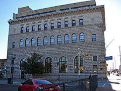
| 76 |
South Jersey Gas, Electric and Traction Company Office Building |
|
000000002005-01-05-0000January 5, 2005
(#04001436) |
418 Federal St.
39°56′51″N 75°07′16″W / 39.9475°N 75.121111°W / 39.9475; -75.121111 (South Jersey Gas, Electric and Traction Company Office Building) |
Camden |
|
| 77 |
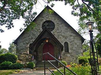
St. John's Episcopal Church and Burying Ground |
|
000000001980-11-22-0000November 22, 1980
(#80002475) |
Chews Landing Rd. and Old Black Horse Pike
39°49′56″N 75°03′48″W / 39.832222°N 75.063333°W / 39.832222; -75.063333 (St. John's Episcopal Church and Burying Ground) |
Runnemede |
|
| 78 |
St. Joseph Polish Catholic Church |
|
000000002003-12-18-0000December 18, 2003
(#03001307) |
1010 Liberty St.
39°55′49″N 75°06′36″W / 39.930278°N 75.11°W / 39.930278; -75.11 (St. Joseph Polish Catholic Church) |
Camden |
|
| 79 |
Station Avenue Business District |
|
000000001989-11-13-0000November 13, 1989
(#89001945) |
Station Ave. from 7th Ave. to White Horse Pike
39°52′56″N 75°03′32″W / 39.882222°N 75.058889°W / 39.882222; -75.058889 (Station Avenue Business District) |
Haddon Heights |
|
| 80 |
Stokes-Lee House |
|
000000001987-09-10-0000September 10, 1987
(#87001519) |
615-617 Lees Ave.
39°54′31″N 75°04′12″W / 39.908611°N 75.07°W / 39.908611; -75.07 (Stokes-Lee House) |
Collingswood |
|
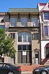
| 81 |
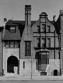
Dr. Henry Genet Taylor House and Office |
|
000000001971-08-12-0000August 12, 1971
(#71000500) |
305 Cooper St.
39°56′51″N 75°07′23″W / 39.9475°N 75.123056°W / 39.9475; -75.123056 (Dr. Henry Genet Taylor House and Office) |
Camden |
|
| 82 |
Thackara House |
|
000000001987-09-10-0000September 10, 1987
(#87001520) |
912 Eldridge Ave.
39°54′29″N 75°05′17″W / 39.908056°N 75.088056°W / 39.908056; -75.088056 (Thackara House) |
Collingswood |
|
| 83 |
Isaac Tomlinson House |
|
000000002005-03-09-0000March 9, 2005
(#05000123) |
834 Blackwood-Clementon Rd.
39°48′16″N 75°00′42″W / 39.804444°N 75.011667°W / 39.804444; -75.011667 (Isaac Tomlinson House) |
Pine Hill |
|
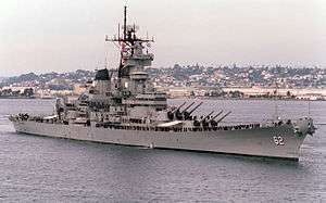
| 84 |
USS New Jersey (BB-62) |
|
000000002004-09-17-0000September 17, 2004
(#04000980) |
62 Battleship Place
39°56′31″N 75°07′57″W / 39.941944°N 75.1325°W / 39.941944; -75.1325 (USS New Jersey (BB-62)) |
Camden |
|
| 85 |
Victory Trust Company |
|
000000001990-08-24-0000August 24, 1990
(#90001257) |
Broadway and Spruce St.
39°56′06″N 75°07′11″W / 39.935°N 75.119722°W / 39.935; -75.119722 (Victory Trust Company) |
Camden |
|
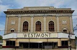
| 86 |
Westmont Theatre |
|
000000002010-10-14-0000October 14, 2010
(#10000834) |
49 Haddon Ave.
39°54′46″N 75°03′14″W / 39.912778°N 75.053889°W / 39.912778; -75.053889 (Westmont Theatre) |
Haddon Township |
|
| 87 |
White Horse Pike Historic District |
|
000000001988-10-27-0000October 27, 1988
(#88002104) |
Roughly bounded by 4th Ave., High and Haddon Sts., E. Atlantic St., the Kings Highway, and Green St.
39°52′58″N 75°03′24″W / 39.882778°N 75.056667°W / 39.882778; -75.056667 (White Horse Pike Historic District) |
Haddon Heights |
|
| 88 |
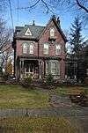
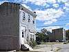
George Whitman House |
|
000000001990-10-11-0000October 11, 1990
(#90001482) |
431 Stevens St.
39°56′31″N 75°07′24″W / 39.941944°N 75.123333°W / 39.941944; -75.123333 (George Whitman House) |
Camden |
Demolished.[6] Photo shows the neighboring building and the empty lot.
|
| 89 |
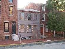
Walt Whitman House |
|
000000001966-10-15-0000October 15, 1966
(#66000461) |
330 Mickle St.
39°56′33″N 75°07′26″W / 39.9425°N 75.123889°W / 39.9425; -75.123889 (Walt Whitman House) |
Camden |
|
| 90 |
Walt Whitman Neighborhood |
|
000000001978-01-20-0000January 20, 1978
(#78001752) |
326-332 Mickle St.
39°56′32″N 75°07′26″W / 39.942222°N 75.123889°W / 39.942222; -75.123889 (Walt Whitman Neighborhood) |
Camden |
|
| 91 |
Wilson Building |
|
000000001990-08-24-0000August 24, 1990
(#90001259) |
Cooper St. and Broadway
39°56′46″N 75°07′08″W / 39.946111°N 75.118889°W / 39.946111; -75.118889 (Wilson Building) |
Camden |
|
| 92 |
Woodlynne Log Cabin |
|
000000001997-08-21-0000August 21, 1997
(#97000933) |
200 block of Cooper Ave.
39°54′58″N 75°05′45″W / 39.916111°N 75.095833°W / 39.916111; -75.095833 (Woodlynne Log Cabin) |
Woodlynne |
|
| 93 |
A.S. Woodruff and Law Buildings |
|
000000001990-08-24-0000August 24, 1990
(#90001264) |
328-330 Market St.
39°56′45″N 75°07′23″W / 39.945833°N 75.123056°W / 39.945833; -75.123056 (A.S. Woodruff and Law Buildings) |
Camden |
|

_CAMDEN_COUNTY%2C_NEW_JERSEY.jpg)