National Register of Historic Places listings in Claiborne County, Tennessee
Location of Claiborne County in Tennessee
This is a list of the National Register of Historic Places listings in Claiborne County, Tennessee.
This is intended to be a complete list of the properties and districts on the National Register of Historic Places in Claiborne County, Tennessee, United States. Latitude and longitude coordinates are provided for many National Register properties and districts; these locations may be seen together in a map.[1]
There are 13 properties and districts in the county are listed on the National Register. Another property was once listed but has been removed.
| Anderson – Bedford – Benton – Bledsoe – Blount – Bradley – Campbell – Cannon – Carroll – Carter – Cheatham – Chester – Claiborne – Clay – Cocke – Coffee – Crockett – Cumberland – Davidson – Decatur – DeKalb – Dickson – Dyer – Fayette – Fentress – Franklin – Gibson – Giles – Grainger – Greene – Grundy – Hamblen – Hamilton – Hancock – Hardeman – Hardin – Hawkins – Haywood – Henderson – Henry – Hickman – Houston – Humphreys – Jackson – Jefferson – Johnson – Knox – Lake – Lauderdale – Lawrence – Lewis – Lincoln – Loudon – Macon – Madison – Marion – Marshall – Maury – McMinn – McNairy – Meigs – Monroe – Montgomery – Moore – Morgan – Obion – Overton – Perry – Pickett – Polk – Putnam – Rhea – Roane – Robertson – Rutherford – Scott – Sequatchie – Sevier – Shelby – Smith – Stewart – Sullivan – Sumner – Tipton – Trousdale – Unicoi – Union – Van Buren – Warren – Washington – Wayne – Weakley – White – Williamson – Wilson |
- This National Park Service list is complete through NPS recent listings posted December 2, 2016.[2]
Current listings
| [3] | Name on the Register[4] | Image | Date listed[5] | Location | City or town | Description |
|---|---|---|---|---|---|---|
| 1 | Big Spring Union Church | 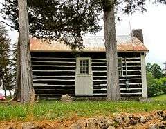 |
(#75001739) |
Off State Route 32 36°25′20″N 83°31′28″W / 36.422222°N 83.524444°W |
Springdale | Also known as the Big Springs Primitive Baptist Church |
| 2 | Claiborne County Jail | 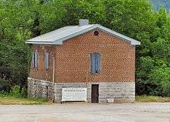 |
(#07000175) |
State Route 33 at U.S. Route 25E 36°27′09″N 83°34′08″W / 36.4525°N 83.568889°W |
Tazewell | |
| 3 | Cumberland Gap Historic District |  |
(#90000321) |
Roughly bounded by Colwyn, Cumberland, Pennlyn, and the former L&N railroad tracks 36°36′00″N 83°40′08″W / 36.600000°N 83.668889°W |
Cumberland Gap | In the town of Cumberland Gap |
| 4 | Cumberland Gap Historic District | 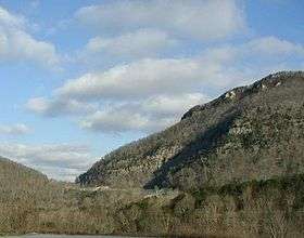 |
(#80000366) |
East of Middlesboro, Kentucky 36°36′14″N 83°40′28″W / 36.603889°N 83.674444°W |
Harrogate | Cumberland Gap, the pass that was used by the Wilderness Road, located within Cumberland Gap National Historical Park.[6] Extends into Bell County, Kentucky, Harlan County, Kentucky, and Lee County, Virginia |
| 5 | Cumberland Gap National Historical Park |  |
(#66000353) |
East of Middlesboro, Kentucky, along the Kentucky-Virginia state line 36°36′14″N 83°40′28″W / 36.603889°N 83.674444°W |
Cumberland Gap | Extends into Bell County, Kentucky and Lee County, Virginia |
| 6 | Graham-Kivette House | 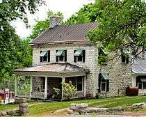 |
(#75001740) |
Junction of Main St. and Old Knoxville Rd. 36°27′07″N 83°34′12″W / 36.451944°N 83.570000°W |
Tazewell | Built circa 1810 by William Graham; later occupied by the Kivett family. |
| 7 | Grant-Lee Hall |  |
(#78002575) |
Lincoln Memorial University campus 36°34′52″N 83°39′33″W / 36.581111°N 83.659167°W |
Harrogate | |
| 8 | Kesterson-Watkins House | Upload image | (#82003958) |
Cedar Fork Rd. 36°29′36″N 83°29′38″W / 36.493333°N 83.493889°W |
Tazewell | |
| 9 | Kincaid House |  |
(#82003957) |
Northeast of Speedwell on Russell Lane 36°28′05″N 83°49′22″W / 36.468056°N 83.822778°W |
Speedwell | Also called the Kincaid-Russell House; built c. 1840 by John Kincaid II for his brother, William H. Kincaid; Nomination form: http://focus.nps.gov/pdfhost/docs/NRHP/Text/82003957.pdf |
| 10 | Kincaid-Ausmus House | 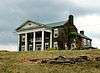 |
(#75001737) |
Northeast of Speedwell off State Route 63 36°29′44″N 83°48′15″W / 36.495556°N 83.804167°W |
Speedwell | Built in 1851 by John Kincaid II for his son, John Kincaid III; Nomination form: http://focus.nps.gov/pdfhost/docs/NRHP/Text/75001737.pdf |
| 11 | McClain-Ellison House | 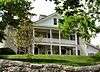 |
(#75001738) |
West of Speedwell on Route 2 off State Route 63 36°27′18″N 83°55′40″W / 36.455°N 83.927778°W |
Speedwell | Built in the 1790s by Thomas McClain; occupied by the Ellison family during the 20th century; Nomination form: http://focus.nps.gov/pdfhost/docs/NRHP/Text/75001738.pdf |
| 12 | Powell Valley Male Academy | 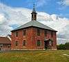 |
(#95000053) |
Junction of Old State Route 63 and Academy Rd. 36°26′40″N 83°55′04″W / 36.444444°N 83.917778°W |
Speedwell | Also known as Speedwell Academy. Built in 1827.[7] |
| 13 | James Wier House | Upload image | (#79002419) |
Eppes St. 36°27′12″N 83°34′14″W / 36.453333°N 83.570556°W |
Tazewell | Moved south of Tazewell |
Former listing
| [3] | Name on the Register | Image | Date listed | Date removed | Location | City or town | Summary |
|---|---|---|---|---|---|---|---|
| 1 | Parkey House | Upload image | (#72001231) | Main St. |
Tazewell |
See also
| Wikimedia Commons has media related to National Register of Historic Places in Claiborne County, Tennessee. |
- List of National Historic Landmarks in Tennessee
- National Register of Historic Places listings in Tennessee
References
- ↑ The latitude and longitude information provided in this table was derived originally from the National Register Information System, which has been found to be fairly accurate for about 99% of listings. For about 1% of NRIS original coordinates, experience has shown that one or both coordinates are typos or otherwise extremely far off; some corrections may have been made. A more subtle problem causes many locations to be off by up to 150 yards, depending on location in the country: most NRIS coordinates were derived from tracing out latitude and longitudes off of USGS topographical quadrant maps created under the North American Datum of 1927, which differs from the current, highly accurate WGS84 GPS system used by most on-line maps. Chicago is about right, but NRIS longitudes in Washington are higher by about 4.5 seconds, and are lower by about 2.0 seconds in Maine. Latitudes differ by about 1.0 second in Florida. Some locations in this table may have been corrected to current GPS standards.
- ↑ "National Register of Historic Places: Weekly List Actions". National Park Service, United States Department of the Interior. Retrieved on December 2, 2016.
- 1 2 Numbers represent an ordering by significant words. Various colorings, defined here, differentiate National Historic Landmarks and historic districts from other NRHP buildings, structures, sites or objects.
- ↑ National Park Service (2008-04-24). "National Register Information System". National Register of Historic Places. National Park Service.
- ↑ The eight-digit number below each date is the number assigned to each location in the National Register Information System database, which can be viewed by clicking the number.
- ↑ "National Register of Historic Places Inventory -- Nomination Form: Cumberland Gap Historic District - Virginia/Kentucky/Tennessee" (PDF). 1978.
- ↑ Tennessee Department of Tourist Development, Historic Speedwell Academy, Tennessee Vacation Guide website
| Topics | |
|---|---|
| Lists by states |
|
| Lists by insular areas | |
| Lists by associated states | |
| Other areas | |
| |
Municipalities and communities of Claiborne County, Tennessee, United States | ||
|---|---|---|
| City | ||
| Towns | ||
| Unincorporated communities | ||
| Footnotes | ‡This populated place also has portions in an adjacent county or counties | |
This article is issued from Wikipedia - version of the 6/7/2016. The text is available under the Creative Commons Attribution/Share Alike but additional terms may apply for the media files.