National Register of Historic Places listings in Coffee County, Georgia
This is a list of properties and districts in Coffee County, Georgia that are listed on the National Register of Historic Places (NRHP).
- This National Park Service list is complete through NPS recent listings posted December 16, 2016.[1]
Current listings
| [2] | Name on the Register | Image | Date listed[3] | Location | City or town | Description |
|---|---|---|---|---|---|---|
| 1 | 63rd Army Air Forces Contract Pilot School (Primary) | |
(#13000270) |
2700 S. Peterson Ave. 31°28′48″N 82°51′08″W / 31.48°N 82.8522°W |
Douglas | At the Douglas Municipal Airport, several buildings used to train pilots in World War II |
| 2 | Downtown Douglas Historic District | 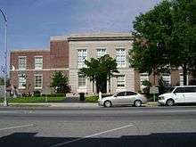 |
(#93000941) |
Roughly bounded by Jackson St., Pearl Ave., Cherry St. and the Georgia-Florida RR tracks 31°30′25″N 82°51′02″W / 31.506944°N 82.850556°W |
Douglas | Union Banking Company in the Downtown Douglas Historic District |
| 3 | Eleventh District A & M School-South Georgia College Historic District | 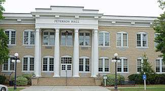 |
(#10000274) |
Roughly bounded by College Park Dr., Brooks & Tiger Rds. 31°29′44″N 82°51′19″W / 31.495425°N 82.855214°W |
Douglas | Includes other buildings at the college, contributing buildings were built 1907-58 |
| 4 | Gaskin Avenue Historic District | 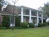 |
(#93001138) |
Roughly bounded by Madison Ave., Wilson St., Pearl Ave., Gordon St., McDonald Ave., Atlantic Coastline RR and Coffee Ave 31°30′38″N 82°50′40″W / 31.510556°N 82.844444°W |
Douglas | |
| 5 | Lonnie A. Pope House | 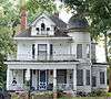 |
(#82002395) |
Jackson St. and Central of Georgia RR tracks (the RR tracks are no longer there - called "Douglas Trail" now) 31°30′39″N 82°51′09″W / 31.510833°N 82.8525°W |
Douglas | Built in 1910 |
| 6 | Union Banking Company Building | 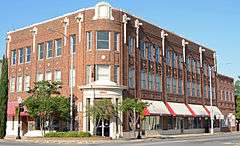 |
(#82000144) |
102 Peterson Ave. 31°30′33″N 82°51′00″W / 31.50904°N 82.85011°W |
Douglas | Built in 1911, also known as the Coffee County Bank |
References
- ↑ "National Register of Historic Places: Weekly List Actions". National Park Service, United States Department of the Interior. Retrieved on December 16, 2016.
- ↑ Numbers represent an ordering by significant words. Various colorings, defined here, differentiate National Historic Landmarks and historic districts from other NRHP buildings, structures, sites or objects.
- ↑ The eight-digit number below each date is the number assigned to each location in the National Register Information System database, which can be viewed by clicking the number.
| Wikimedia Commons has media related to National Register of Historic Places in Coffee County, Georgia. |
This article is issued from Wikipedia - version of the 8/20/2016. The text is available under the Creative Commons Attribution/Share Alike but additional terms may apply for the media files.