National Register of Historic Places listings in Early County, Georgia
This is a list of properties and districts in Early County, Georgia that are listed on the National Register of Historic Places (NRHP).
- This National Park Service list is complete through NPS recent listings posted December 16, 2016.[1]
Current listings
| [2] | Name on the Register | Image | Date listed[3] | Location | City or town | Description |
|---|---|---|---|---|---|---|
| 1 | Bank of Jakin | Upload image | (#03000678) |
135 S. Pearl St. 31°05′22″N 84°58′59″W / 31.089444°N 84.983056°W |
Jakin | |
| 2 | Blakely Court Square Historic District | Upload image | (#02000452) |
Bounded by Powell St., Smith Ave., and Church and Bay Sts. 31°22′38″N 84°56′02″W / 31.377222°N 84.933889°W |
Blakely | |
| 3 | James and Clara Butler House | Upload image | (#01001430) |
418 College St. 31°22′44″N 84°56′27″W / 31.378889°N 84.940833°W |
Blakely | |
| 4 | Coheelee Creek Covered Bridge | 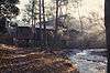 |
(#76000617) |
2 mi. N of Hilton on Old River Rd. 31°18′23″N 85°04′43″W / 31.30641°N 85.07871°W |
Hilton | |
| 5 | Early County Courthouse |  |
(#80001015) |
Courthouse Sq. 31°22′39″N 84°56′03″W / 31.3775°N 84.934167°W |
Blakely | |
| 6 | Jane Donalson Harrell House | Upload image | (#82002407) |
SR 1975 off U.S. 84 31°05′01″N 84°59′47″W / 31.083611°N 84.996389°W |
Jakin | |
| 7 | Kolomoki Mounds |  |
(#66000280) |
8 mi. N of Blakely on U.S. 27, Kolomoki Mounds State Park Coordinates missing |
Blakely | National Historic Landmark and a Georgia state historic site |
References
- ↑ "National Register of Historic Places: Weekly List Actions". National Park Service, United States Department of the Interior. Retrieved on December 16, 2016.
- ↑ Numbers represent an ordering by significant words. Various colorings, defined here, differentiate National Historic Landmarks and historic districts from other NRHP buildings, structures, sites or objects.
- ↑ The eight-digit number below each date is the number assigned to each location in the National Register Information System database, which can be viewed by clicking the number.
| Wikimedia Commons has media related to National Register of Historic Places in Early County, Georgia. |
| Topics | |
|---|---|
| Lists by states |
|
| Lists by insular areas | |
| Lists by associated states | |
| Other areas | |
| |
This article is issued from Wikipedia - version of the 6/27/2016. The text is available under the Creative Commons Attribution/Share Alike but additional terms may apply for the media files.