| [3] |
Name on the Register |
Image |
Date listed[4] |
Location |
City or town |
Description |
|---|
| 1 |
Alpina Archeological District |
Upload image |
000000001995-11-02-0000November 2, 1995
(#95000068) |
Address Restricted
|
Diana |
|
| 2 |
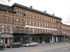
Bateman Hotel |
|
000000001994-02-18-0000February 18, 1994
(#94000046) |
7574 S. State St.
43°47′10″N 75°29′31″W / 43.786111°N 75.491944°W / 43.786111; -75.491944 (Bateman Hotel) |
Lowville |
|
| 3 |
Beaver Falls Grange Hall No. 554 |
Upload image |
000000002015-12-01-0000December 1, 2015
(#15000852) |
9577 Main St.
43°53′08″N 75°25′52″W / 43.8854986°N 75.4310404°W / 43.8854986; -75.4310404 (Beaver Falls Grange Hall No. 554) |
Beaver Falls |
1892 building was education and entertainment center in small agricultural community
|
| 4 |
Jonathan C. Collins House and Cemetery |
Upload image |
000000001988-11-09-0000November 9, 1988
(#88002137) |
West Rd.
43°34′07″N 75°25′14″W / 43.568611°N 75.420556°W / 43.568611; -75.420556 (Jonathan C. Collins House and Cemetery) |
Constableville |
|
| 5 |
Collinsville Cemetery |
Upload image |
000000002014-05-07-0000May 7, 2014
(#14000192) |
4061 East Rd.
43°37′35″N 75°23′46″W / 43.626412°N 75.3960717°W / 43.626412; -75.3960717 (Collinsville Cemetery) |
West Turin vicinity |
|
| 6 |
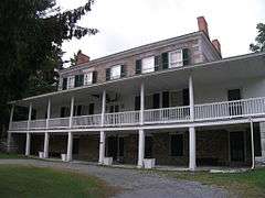
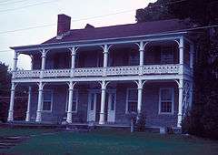
Constable Hall |
|
000000001973-03-07-0000March 7, 1973
(#73001197) |
Off NY 26
43°33′43″N 75°25′24″W / 43.561944°N 75.423333°W / 43.561944; -75.423333 (Constable Hall) |
Constableville |
|
| 7 |
Constableville Village Historic District |
|
000000001983-09-15-0000September 15, 1983
(#83001703) |
Roughly bounded by Sugar River, Main, N. Main, W. Main, Church, High, West and James Sts.
43°33′51″N 75°25′50″W / 43.564167°N 75.430556°W / 43.564167; -75.430556 (Constableville Village Historic District) |
Constableville |
|
| 8 |
Croghan Island Mill |
Upload image |
000000002010-07-30-0000July 30, 2010
(#10000515) |
9897 S. Bridge St.
43°53′52″N 75°23′37″W / 43.897778°N 75.393611°W / 43.897778; -75.393611 (Croghan Island Mill) |
Croghan vicinity |
|
| 9 |
Forest Presbyterian Church |
Upload image |
000000002004-09-24-0000September 24, 2004
(#04001060) |
4109 Center St.
43°37′05″N 75°21′41″W / 43.618056°N 75.361389°W / 43.618056; -75.361389 (Forest Presbyterian Church) |
Lyons Falls |
|
| 10 |
Gould Mansion Complex |
|
000000001978-04-19-0000April 19, 1978
(#78001857) |
Main St.
43°37′05″N 75°21′38″W / 43.618056°N 75.360556°W / 43.618056; -75.360556 (Gould Mansion Complex) |
Lyons Falls |
|
| 11 |
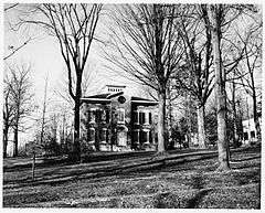
Franklin B. Hough House |
|
000000001966-10-15-0000October 15, 1966
(#66000526) |
Collins St.
43°47′22″N 75°29′50″W / 43.789444°N 75.497222°W / 43.789444; -75.497222 (Franklin B. Hough House) |
Lowville |
|
| 12 |
Lewis County Fairgrounds |
Upload image |
000000002002-02-14-0000February 14, 2002
(#02000006) |
Bostwick St.
43°47′43″N 75°29′25″W / 43.795278°N 75.490278°W / 43.795278; -75.490278 (Lewis County Fairgrounds) |
Lowville |
|
| 13 |
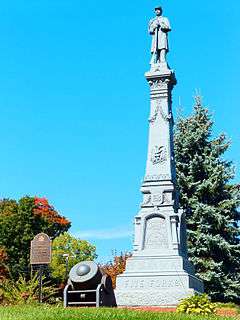
Lewis County Soldiers' and Sailors' Monument |
|
000000002009-07-29-0000July 29, 2009
(#09000575) |
Village Green, NY 26 and Bostwick Sts.
43°47′27″N 75°29′44″W / 43.790925°N 75.495592°W / 43.790925; -75.495592 (Lewis County Soldiers' and Sailors' Monument) |
Lowville |
|
| 14 |
Harry and Molly Lewis House |
Upload image |
000000002012-11-21-0000November 21, 2012
(#12000956) |
9520 E. Main St.
43°53′06″N 75°25′39″W / 43.884961°N 75.427377°W / 43.884961; -75.427377 (Harry and Molly Lewis House) |
Beaver Falls vicinity |
|
| 15 |
Lewisburg Archeological District |
Upload image |
000000001995-11-02-0000November 2, 1995
(#95000071) |
Address Restricted
|
Diana |
|
| 16 |
Leyden Common School No. 2 |
Upload image |
000000002016-06-21-0000June 21, 2016
(#16000392) |
6606 School Rd.
Coordinates missing |
Talcottville |
1870 one-room schoolhouse in use for almost a century afterward
|
| 17 |
Lowville Masonic Temple |
Upload image |
000000002008-09-19-0000September 19, 2008
(#08000919) |
7552 S. State St.
43°47′10″N 75°29′28″W / 43.786122°N 75.491098°W / 43.786122; -75.491098 (Lowville Masonic Temple) |
Lowville |
|
| 18 |
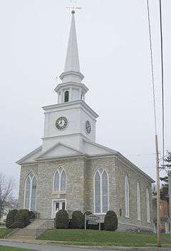
Lowville Presbyterian Church |
|
000000002007-06-27-0000June 27, 2007
(#07000623) |
7707 North State St.
43°47′28″N 75°29′47″W / 43.791111°N 75.496389°W / 43.791111; -75.496389 (Lowville Presbyterian Church) |
Lowville |
|
| 19 |
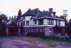
Gen. Walter Martin House |
Upload image |
000000002008-07-24-0000July 24, 2008
(#08000698) |
6575 Main St.
43°44′16″N 75°28′09″W / 43.737778°N 75.469167°W / 43.737778; -75.469167 (Gen. Walter Martin House) |
Martinsburg |
|
| 20 |
Martinsburg Town Hall |
Upload image |
000000002001-03-21-0000March 21, 2001
(#01000241) |
NY 26 Main St., E
43°44′14″N 75°28′08″W / 43.737222°N 75.468889°W / 43.737222; -75.468889 (Martinsburg Town Hall) |
Martinsburg |
|
| 21 |
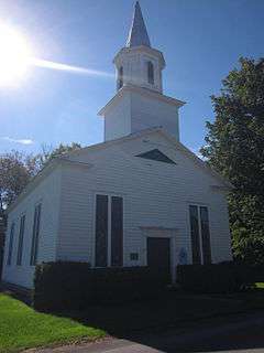
Methodist Episcopal Church of West Martinsburg |
|
000000001983-09-15-0000September 15, 1983
(#83001704) |
W. Martinsburg Rd.
43°45′35″N 75°31′00″W / 43.759722°N 75.516667°W / 43.759722; -75.516667 (Methodist Episcopal Church of West Martinsburg) |
West Martinsburg |
|
| 22 |
Moser Farm |
Upload image |
000000002010-07-30-0000July 30, 2010
(#10000516) |
8778 Erie Canal Rd.
43°53′32″N 75°20′06″W / 43.892222°N 75.335°W / 43.892222; -75.335 (Moser Farm) |
Kirschnerville vicinity |
|
| 23 |
Old Lowville Cemetery |
Upload image |
000000002016-08-22-0000August 22, 2016
(#16000553) |
5515 Jackson and 5575 River Sts.
Coordinates missing |
Lowville |
One of the oldest cemeteries in the county holds the graves of many early Lowville settlers and war veterans
|
| 24 |
Osceola Town Hall |
Upload image |
000000002005-12-22-0000December 22, 2005
(#05001454) |
N. Ocseola Rd.
43°30′11″N 75°43′21″W / 43.503056°N 75.7225°W / 43.503056; -75.7225 (Osceola Town Hall) |
Osceola |
|
| 25 |
Pinckney Corners Cemetery |
Upload image |
000000002014-09-10-0000September 10, 2014
(#14000578) |
Pinckney Rd.
43°52′03″N 75°43′29″W / 43.86754689406119°N 75.72477039324879°W / 43.86754689406119; -75.72477039324879 (Pinckney Corners Cemetery) |
Copenhagen vicinity. |
Graves in town's oldest cemetery date back to 1810; those buried include veterans of Revolutionary War and War of 1812
|
| 26 |
Pine Grove Community Church |
Upload image |
000000002009-08-20-0000August 20, 2009
(#09000633) |
Austin Rd. & Pine Grove Rd.
43°45′07″N 75°22′39″W / 43.751833°N 75.377372°W / 43.751833; -75.377372 (Pine Grove Community Church) |
Pine Grove |
|
| 27 |
The Pines |
Upload image |
000000002007-06-27-0000June 27, 2007
(#07000621) |
3998-4000 Lyons Falls Rd.
43°37′23″N 75°21′32″W / 43.623056°N 75.358889°W / 43.623056; -75.358889 (The Pines) |
Lyons Falls |
|
| 28 |
St. Mark's Church |
Upload image |
000000001998-08-06-0000August 6, 1998
(#98001003) |
Jct. of West Main and Elm Sts.
43°34′52″N 75°20′59″W / 43.581111°N 75.349722°W / 43.581111; -75.349722 (St. Mark's Church) |
Port Leyden |
|
| 29 |
Stoddard–O'Connor House |
Upload image |
000000002011-06-23-0000June 23, 2011
(#11000402) |
5431 Shady Ave.
43°47′14″N 75°29′20″W / 43.787222°N 75.488889°W / 43.787222; -75.488889 (Stoddard–O'Connor House) |
Lowville |
|
| 30 |
Wildwood Cemetery and Mary Lyon Fisher Memorial Chapel |
Upload image |
000000002011-06-27-0000June 27, 2011
(#11000403) |
River Rd.
43°36′30″N 75°20′43″W / 43.608333°N 75.345278°W / 43.608333; -75.345278 (Wildwood Cemetery and Mary Lyon Fisher Memorial Chapel) |
Lyons Falls |
|
| 31 |
Edmund Wilson House |
|
000000001973-11-26-0000November 26, 1973
(#73001198) |
S of Port Leyden off NY 12 on Talcottville Rd.
43°32′05″N 75°21′59″W / 43.534722°N 75.366389°W / 43.534722; -75.366389 (Edmund Wilson House) |
Port Leyden |
|