National Register of Historic Places listings in McDuffie County, Georgia
This is a list of properties and districts in McDuffie County, Georgia that are listed on the National Register of Historic Places (NRHP).
- This National Park Service list is complete through NPS recent listings posted December 16, 2016.[1]
Current listings
| [2] | Name on the Register | Image | Date listed[3] | Location | City or town | Description |
|---|---|---|---|---|---|---|
| 1 | Boneville Historic District | Upload image | (#00000072) |
Jct. of Boneville Rd. and the Georgia RR, approx. 5 mi. SE of Thomson 33°25′59″N 82°26′17″W / 33.433056°N 82.438056°W |
Boneville | |
| 2 | Bowdre-Rees-Knox House | Upload image | (#79003109) |
SW of Thomson on Old Wrightsboro Rd. 33°32′17″N 82°32′52″W / 33.538056°N 82.547778°W |
Thomson | |
| 3 | Thomas Carr District | Upload image | (#75002059) |
N of Thomason near jct. of GA 150 and I-20 33°31′43″N 82°26′33″W / 33.528611°N 82.4425°W |
Thomson | |
| 4 | James L. Hardaway House | 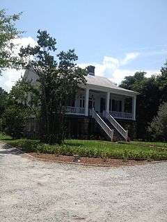 |
(#93000942) |
Old Mesena Rd. W of Thomson 33°26′53″N 82°34′41″W / 33.448056°N 82.578056°W |
Thomson | |
| 5 | Hayes Line Historic District | Upload image | (#00000106) |
Jct. of Twin Oaks Rd. and GA 233 33°28′08″N 82°31′15″W / 33.468889°N 82.520833°W |
Thomson | |
| 6 | Hickory Hill | 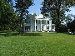 |
(#79003110) |
Hickory Hill Dr. and Lee St. 33°28′18″N 82°30′46″W / 33.471667°N 82.512778°W |
Thomson | |
| 7 | Hillman-Bowden House | Upload image | (#02001259) |
1348 Pyland Crossing Rd. 33°26′14″N 82°33′20″W / 33.437222°N 82.555556°W |
Thomson | |
| 8 | John Moore Lazenby House | Upload image | (#13000241) |
1353 Cedar Rock Rd. 33°29′04″N 82°31′36″W / 33.484556°N 82.526743°W |
Thomson vicinity | |
| 9 | McNeill House | Upload image | (#92001637) |
220 Lee St. 33°28′01″N 82°30′28″W / 33.466944°N 82.507778°W |
Thomson | |
| 10 | Old Rock House | .jpg) |
(#70000841) |
NW of Thomson on Old Rock House Rd. Coordinates missing |
Thomson | |
| 11 | Pine Top Farm | Upload image | (#96000582) |
Jct. of US 78 and US 278, 2 mi. E of Thomson 33°27′24″N 82°28′04″W / 33.456667°N 82.467778°W |
Thomson | |
| 12 | Sweetwater Inn | Upload image | (#85000938) |
Off GA 17 on Old Milledgeville Rd. 33°24′58″N 82°27′19″W / 33.416111°N 82.455278°W |
Thomson | |
| 13 | Thomson Commercial Historic District | 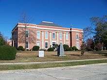 |
(#89000413) |
Roughly bounded by Journal St., Greenway St., Railroad St., Hendricks St., and Church St. 33°27′58″N 82°30′05″W / 33.466111°N 82.501389°W |
Thomson | |
| 14 | Usry House | 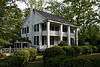 |
(#74002182) |
211 Milledge St. 33°27′58″N 82°30′20″W / 33.466111°N 82.505556°W |
Thomson | |
| 15 | Thomas E. Watson House | |
(#76002144) |
310 Lumpkin St. 33°28′11″N 82°30′32″W / 33.469722°N 82.508889°W |
Thomson | Home of Georgia Populist Party co-founder Thomas E. Watson, is a National Historic Landmark |
| 16 | Wrightsboro Historic District | Upload image | (#98000701) |
Wrightsboro Rd., E. of Ridge Rd. 33°33′00″N 82°34′09″W / 33.55°N 82.569167°W |
Wrightsboro |
References
| Wikimedia Commons has media related to National Register of Historic Places in McDuffie County, Georgia. |
- ↑ "National Register of Historic Places: Weekly List Actions". National Park Service, United States Department of the Interior. Retrieved on December 16, 2016.
- ↑ Numbers represent an ordering by significant words. Various colorings, defined here, differentiate National Historic Landmarks and historic districts from other NRHP buildings, structures, sites or objects.
- ↑ The eight-digit number below each date is the number assigned to each location in the National Register Information System database, which can be viewed by clicking the number.
This article is issued from Wikipedia - version of the 9/21/2016. The text is available under the Creative Commons Attribution/Share Alike but additional terms may apply for the media files.