National Register of Historic Places listings in McIntosh County, Georgia
This is a list of properties and districts in McIntosh County, Georgia that are listed on the National Register of Historic Places (NRHP).
- This National Park Service list is complete through NPS recent listings posted December 16, 2016.[1]
Current listings
| [2] | Name on the Register | Image | Date listed[3] | Location | City or town | Description |
|---|---|---|---|---|---|---|
| 1 | Ashantilly | 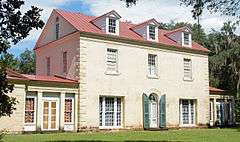 |
(#15000103) |
15591 GA 99 (actually on Bond Rd. between St. Andrews Cemetery Rd. and Ashantilly Rd.) 31°22′52″N 81°24′47″W / 31.381165°N 81.413051°W |
Darien | Home of Thomas Spalding. It is also known as "Old Tabby". Original house built ca. 1820, burned in 1937 and rebuilt. Now houses the Ashantilly Center website announcement |
| 2 | Behavior Cemetery | Upload image | (#96000915) |
S end of Sapelo Island, 1.25 mi W of Hog Hammock 31°25′43″N 81°16′52″W / 31.428611°N 81.281111°W |
Hog Hammock | |
| 3 | D'Antignac House | Upload image | (#77001503) |
Address Restricted (was on Baisden's Bluff on the Crescent River) |
Crescent | Demolished in 2007[4] |
| 4 | First African Baptist Church at Raccoon Bluff | Upload image | (#96000916) |
E side of Sapelo Island, approximately 2 mi. N of Hog Hammock 31°28′02″N 81°13′56″W / 31.46710°N 81.23220°W |
Hog Hammock | |
| 5 | Fort Barrington | 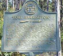 |
(#72001447) |
NW of Cox 31°28′49″N 81°37′00″W / 31.480278°N 81.616667°W |
Cox | The site of Fort Barrington is on private property, no marker there. The marker is 10 miles away, on Georgia highway 57, at the border of McIntosh County and Long County. |
| 6 | Fort King George | 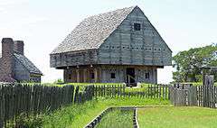 |
(#71001101) |
E of U.S. 17 off Ft. King George Rd, at 302 McIntosh Rd. in Darien 31°21′55″N 81°24′54″W / 31.365384°N 81.41493°W |
Darien | Now a Georgia state historic site |
| 7 | Hog Hammock Historic District |  |
(#96000917) |
E side of Sapelo Island 31°25′40″N 81°15′38″W / 31.427778°N 81.260556°W |
Hog Hammock | |
| 8 | The Ridge | _(02).jpg) |
(#85000863) |
Old Shell Rd. GA 99 31°24′12″N 81°24′13″W / 31.403333°N 81.403611°W |
Ridgeville | |
| 9 | Sapelo Island Lighthouse | 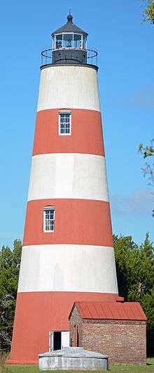 |
(#97000335) |
S end of Sapelo Island, S of University of Georgia Marine Institute 31°23′29″N 81°17′08″W / 31.39127°N 81.28568°W |
Sapelo Island | |
| 10 | Vernon Square-Columbus Square Historic District | 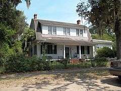 |
(#85000581) |
Roughly bounded by Market, Trumbull, Rittenhouse and Ft. King George Dr. 31°22′10″N 81°25′55″W / 31.369444°N 81.431944°W |
Darien | |
| 11 | West Darien Historic District |  |
(#01000975) |
Bounded by 8th St., US 17, Darien River, and Cathead Creek 31°22′22″N 81°26′13″W / 31.372778°N 81.436944°W |
Darien |
References
- ↑ "National Register of Historic Places: Weekly List Actions". National Park Service, United States Department of the Interior. Retrieved on December 16, 2016.
- ↑ Numbers represent an ordering by significant words. Various colorings, defined here, differentiate National Historic Landmarks and historic districts from other NRHP buildings, structures, sites or objects.
- ↑ The eight-digit number below each date is the number assigned to each location in the National Register Information System database, which can be viewed by clicking the number.
- ↑ McIntosh growth has a price tag, December 23, 2007, Mike Morrison, Florida Times-Union
| Wikimedia Commons has media related to National Register of Historic Places in McIntosh County, Georgia. |
This article is issued from Wikipedia - version of the 6/27/2016. The text is available under the Creative Commons Attribution/Share Alike but additional terms may apply for the media files.