| [3] |
Name on the Register[4] |
Image |
Date listed[5] |
Location |
City or town |
Description |
|---|
| 1 |
Ayden Historic District |
Upload image |
000000001994-08-26-0000August 26, 1994
(#94001026) |
Roughly bounded by Verna St., Peachtree St., E. College St. and Planters St.
35°28′09″N 77°25′13″W / 35.469167°N 77.420278°W / 35.469167; -77.420278 (Ayden Historic District) |
Ayden |
|
| 2 |
College View Historic District |
|
000000001992-03-19-0000March 19, 1992
(#92000181) |
Roughly bounded by Holly, Eastern, E. First and E. Fifth Sts.
35°36′37″N 77°21′54″W / 35.610278°N 77.365°W / 35.610278; -77.365 (College View Historic District) |
Greenville |
|
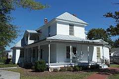
| 3 |
Cox-Ange House |
|
000000002000-10-06-0000October 6, 2000
(#00001181) |
113 N. Church St.
35°31′43″N 77°24′04″W / 35.528611°N 77.401111°W / 35.528611; -77.401111 (Cox-Ange House) |
Winterville |
|
| 4 |
Dickinson Avenue Historic District |
|
000000002007-03-01-0000March 1, 2007
(#07000092) |
600-900 blocks Dickinson Ave., one block of side streets, including W. Eighth, Flicklien, S. Pitt, Clark Sts., Atlantic, Albermarle
35°36′27″N 77°22′47″W / 35.607453°N 77.379811°W / 35.607453; -77.379811 (Dickinson Avenue Historic District) |
Greenville |
|
| 5 |
Dupree-Moore Farm |
Upload image |
000000002012-08-28-0000August 28, 2012
(#12000579) |
3901 Buck Moore Rd.
35°43′47″N 77°32′25″W / 35.729722°N 77.54025°W / 35.729722; -77.54025 (Dupree-Moore Farm) |
Falkland vicinity |
|
| 6 |
Falkland Historic District |
Upload image |
000000002012-10-03-0000October 3, 2012
(#12000833) |
Roughly Crisp, N. Main, & S. Main Sts., & West Ave.
35°41′56″N 77°30′51″W / 35.698908°N 77.514056°W / 35.698908; -77.514056 (Falkland Historic District) |
Falkland |
|
| 7 |
Farmville Historic District |
Upload image |
000000001993-10-21-0000October 21, 1993
(#93001121) |
Roughly bounded by Turnage, Pine, Jones, and Waverly Sts.
35°35′56″N 77°35′11″W / 35.598889°N 77.586389°W / 35.598889; -77.586389 (Farmville Historic District) |
Farmville |
|
| 8 |
E. B. Ficklen House |
|
000000001984-12-20-0000December 20, 1984
(#84000564) |
508 W. 5th St.
35°36′45″N 77°22′47″W / 35.6125°N 77.379722°W / 35.6125; -77.379722 (E. B. Ficklen House) |
Greenville |
|
| 9 |
James L. Fleming House |
|
000000001983-07-21-0000July 21, 1983
(#83001903) |
302 S. Greene St.
35°36′47″N 77°22′30″W / 35.613056°N 77.375°W / 35.613056; -77.375 (James L. Fleming House) |
Greenville |
|
| 10 |
Fountain Historic District |
Upload image |
000000002016-05-03-0000May 3, 2016
(#16000221) |
Roughly bounded by Smith St., Blount St., extending along Wilson St., between Church and Stamper Sts.
35°40′28″N 77°38′19″W / 35.674363°N 77.638667°W / 35.674363; -77.638667 (Fountain Historic District) |
Fountain |
|
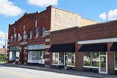
| 11 |
Greenville Commercial Historic District |
|
000000002003-08-21-0000August 21, 2003
(#03000419) |
Roughly bounded by West Third, South Evans and East and West Fifth Sts.
35°36′42″N 77°22′23″W / 35.611667°N 77.373056°W / 35.611667; -77.373056 (Greenville Commercial Historic District) |
Greenville |
|
| 12 |
Greenville Tobacco Warehouse Historic District |
|
000000001997-07-17-0000July 17, 1997
(#97000726) |
Roughly bounded by 12th, Clark, Ficklen, and Washington Sts.
• Greenville, North Carolina Warehouse Historic District boundary increase (listed 000000001999-11-30-0000November 30, 1999, refnum 99001450): Eleventh St. near Clark St.
35°36′23″N 77°22′37″W / 35.606389°N 77.376944°W / 35.606389; -77.376944 (Greenville Tobacco Warehouse Historic District) |
Greenville |
|
| 13 |
Greenwreath |
Upload image |
000000001982-04-29-0000April 29, 1982
(#82003498) |
West of Greenville
35°36′43″N 77°24′02″W / 35.611944°N 77.400556°W / 35.611944; -77.400556 (Greenwreath) |
Greenville |
|
| 14 |
Grimesland Plantation |
|
000000001971-03-31-0000March 31, 1971
(#71000616) |
East of Grimesland on SR 1569
35°33′22″N 77°10′02″W / 35.556111°N 77.167222°W / 35.556111; -77.167222 (Grimesland Plantation) |
Grimesland |
|
| 15 |
Spencer Harris House |
Upload image |
000000002005-01-20-0000January 20, 2005
(#04001527) |
1287 NC 121
35°39′15″N 77°30′51″W / 35.654167°N 77.514167°W / 35.654167; -77.514167 (Spencer Harris House) |
Falkland |
|
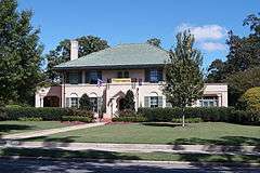
| 16 |
Robert Lee Humber House |
|
000000001981-07-09-0000July 9, 1981
(#81000425) |
117 W. 5th St.
35°36′39″N 77°22′18″W / 35.610833°N 77.371667°W / 35.610833; -77.371667 (Robert Lee Humber House) |
Greenville |
|
| 17 |
Jones-Lee House |
|
000000001980-11-25-0000November 25, 1980
(#80002894) |
805 E. Evans St.
35°36′27″N 77°22′29″W / 35.6075°N 77.374722°W / 35.6075; -77.374722 (Jones-Lee House) |
Greenville |
|
| 18 |
Kittrell-Dail House |
Upload image |
000000002000-03-24-0000March 24, 2000
(#00000287) |
Junction of NC 1117 and NC 1114
35°30′44″N 77°29′14″W / 35.512222°N 77.487222°W / 35.512222; -77.487222 (Kittrell-Dail House) |
Renston |
|
| 19 |
Robert J. Lang Jr. House |
Upload image |
000000001990-08-23-0000August 23, 1990
(#90001313) |
SR 1231, 0.1 miles (0.16 km) south of the junction with SR 1200
35°37′58″N 77°40′32″W / 35.632778°N 77.675556°W / 35.632778; -77.675556 (Robert J. Lang Jr. House) |
Fountain |
|
| 20 |
William H. Long House |
|
000000001982-04-15-0000April 15, 1982
(#82003499) |
200 E. 4th St.
35°26′43″N 77°22′31″W / 35.445278°N 77.375278°W / 35.445278; -77.375278 (William H. Long House) |
Greenville |
|
| 21 |
Benjamin May-Lewis House |
Upload image |
000000001985-06-20-0000June 20, 1985
(#85001337) |
US 264-A
35°36′35″N 77°38′36″W / 35.609722°N 77.643333°W / 35.609722; -77.643333 (Benjamin May-Lewis House) |
Farmville |
|
| 22 |
Jesse R. Moye House |
|
000000001997-10-17-0000October 17, 1997
(#97001220) |
408 W. Fifth St.
35°36′43″N 77°22′38″W / 35.611944°N 77.377222°W / 35.611944; -77.377222 (Jesse R. Moye House) |
Greenville |
|
| 23 |
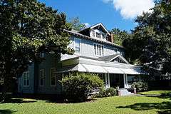
Oakmont |
Upload image |
000000002001-10-15-0000October 15, 2001
(#01001115) |
2909 S. Memorial Dr.
35°34′59″N 77°23′45″W / 35.583056°N 77.395833°W / 35.583056; -77.395833 (Oakmont) |
Greenville |
|
| 24 |
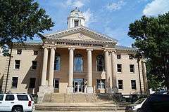
Pitt County Courthouse |
|
000000001979-05-10-0000May 10, 1979
(#79001745) |
N. 3rd St. between Washington and S. Evan St.
35°36′49″N 77°22′23″W / 35.613611°N 77.373056°W / 35.613611; -77.373056 (Pitt County Courthouse) |
Greenville |
part of the North Carolina County Courthouses Thematic Resource (TR)
|
| 25 |
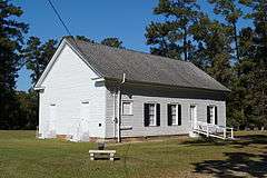
Red Banks Primitive Baptist Church |
|
000000002002-02-20-0000February 20, 2002
(#02000060) |
NC 1704, junction with NC 1725
35°34′18″N 77°20′28″W / 35.571667°N 77.341111°W / 35.571667; -77.341111 (Red Banks Primitive Baptist Church) |
Bell Fork |
|
| 26 |
Renston Rural Historic District |
Upload image |
000000002003-12-04-0000December 4, 2003
(#03001236) |
Approximately 2.5 miles (4.0 km) along NC 903, roughly bounded by NC 1127 and Stokes Ln.
35°31′33″N 77°28′43″W / 35.525833°N 77.478611°W / 35.525833; -77.478611 (Renston Rural Historic District) |
Winterville |
|
| 27 |
Thomas Sheppard Farm |
Upload image |
000000002000-05-18-0000May 18, 2000
(#00000517) |
NC 1550, near the junction of NC 1552
35°41′37″N 77°12′35″W / 35.693611°N 77.209722°W / 35.693611; -77.209722 (Thomas Sheppard Farm) |
Stokes |
|
| 28 |
Skinnerville-Greenville Heights Historic District |
|
000000002005-12-23-0000December 23, 2005
(#05001452) |
Roughly bounded by Pitt St., Martin Luther King Kr. Dr., Ward St., White St., Tyson St., Fairfax St., the Tar River
35°35′20″N 77°22′53″W / 35.588889°N 77.381389°W / 35.588889; -77.381389 (Skinnerville-Greenville Heights Historic District) |
Greenville |
|
| 29 |
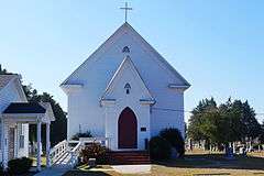
St. John's Episcopal Church |
|
000000001986-12-02-0000December 2, 1986
(#86003268) |
SE corner of SR 1917 and SR 1753
35°22′24″N 77°21′36″W / 35.373333°N 77.36°W / 35.373333; -77.36 (St. John's Episcopal Church) |
St. John's |
|
| 30 |
US Post Office |
|
000000001986-02-06-0000February 6, 1986
(#86000784) |
215 S. Evans St.
35°36′47″N 77°22′21″W / 35.613056°N 77.3725°W / 35.613056; -77.3725 (US Post Office) |
Greenville |
|

.JPG)

