Neshaminy Creek
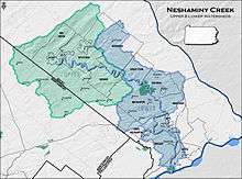

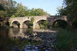
Neshaminy Creek /nᵻˈʃæmɪni/[1] is a 40.7-mile-long (65.5 km)[2] stream that runs entirely through Bucks County, Pennsylvania, rising south of the borough of Chalfont, where its north and west branches join.[1] Neshaminy Creek flows southeast toward Bristol Township and Bensalem Township to its confluence with the Delaware River. The name "Neshaminy" originates with the Lenni Lenape and is thought to mean "place where we drink twice".[3] This phenomenon refers to a section of the creek known as the Neshaminy Palisades, where the course of the water slows and changes direction at almost a right angle, nearly forcing the water back upon itself.[3] These palisades are located in Dark Hollow Park,[4] operated by the county, and are flanked by Warwick Township to the south and Buckingham Township to the north.[5][6]
Statistics
The watershed of the Neshaminy Creek covers an area of approximately 236 square miles (610 km2), 86 percent of which is located in Bucks County and 14 percent in Montgomery County. It is part of the greater Delaware River watershed. The creek's course runs mostly through suburban areas to the north of Philadelphia. However, the course of the creek does run through a few sections of rural and semi-rural terrain, and some forested areas remain. Neshaminy Creek passes through two state parks, Tyler State Park and Neshaminy State Park.
Adjacent municipalities

- Bensalem Township
- Bristol Township
- Buckingham Township
- Chalfont
- Doylestown
- Doylestown Township
- Hatfield
- Hulmeville
- Ivyland
- Langhorne
- Langhorne Manor
- Lansdale
- Lower Southampton Township
- Middletown Township
- New Britain
- New Britain Township
- Newtown
- Newtown Township
- Northampton Township
- Penndel
- Plumstead Township
- Upper Southampton Township
- Warminster Township
- Warwick Township
- Wrightstown Township
Flooding
Like other rivers and streams, the Neshaminy Creek poses a flooding threat to neighboring areas in times of rapid downpours. The waters of the creek have been known to rise more than 10 feet (3 m) above their normal level during severe storms, such as Hurricane Floyd, which hit the area on September 16, 1999. In 2005, the Natural Resources Conservation Service earmarked $3 million for flood mitigation programs along the Neshaminy Creek. The creek was the site of significant flooding again from June 25 through July 5, 2006 during the Mid-Atlantic United States flood of 2006. In Late August through Early September 2011, Hurricane Irene, and Tropical Storm Lee (2011) rose the Neshaminy Creek to levels haven't seen before in 100 years. Repairs cost around 1 million USD total.
See also
References
- 1 2 Neshaminy Creek
- ↑ U.S. Geological Survey. National Hydrography Dataset high-resolution flowline data.The National Map, accessed April 1, 2011
- 1 2 delawareriverkeeper
- ↑ Dark Hollow Park
- ↑ delaware river keeper
- ↑ heritage conservancy
Sources and external links
| Wikimedia Commons has media related to Neshaminy Creek. |
- U.S. Geological Survey: PA stream gaging stations
- http://www.delawareriverkeeper.org/factsheets/neshaminy.html
- http://fitzpatrick.house.gov/News/DocumentPrint.aspx?DocumentID=36389
- Map of the Forks of the Neshaminy (showing the nearly right angle in the creek within Dark Hollow Park)
- Dark Hollow Park Fact Sheet
Coordinates: 40°05′39″N 74°54′49″W / 40.09412°N 74.91356°W