Neuendettelsau
| Neuendettelsau | ||
|---|---|---|
|
Neuendettelsau in the 1970s | ||
| ||
 Neuendettelsau | ||
Location of Neuendettelsau within Ansbach district 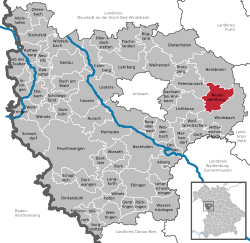 | ||
| Coordinates: 49°16′N 10°46′E / 49.267°N 10.767°ECoordinates: 49°16′N 10°46′E / 49.267°N 10.767°E | ||
| Country | Germany | |
| State | Bavaria | |
| Admin. region | Mittelfranken | |
| District | Ansbach | |
| Government | ||
| • Mayor | Gerhard Korn (CSU) | |
| Area | ||
| • Total | 33.8 km2 (13.1 sq mi) | |
| Population (2015-12-31)[1] | ||
| • Total | 7,674 | |
| • Density | 230/km2 (590/sq mi) | |
| Time zone | CET/CEST (UTC+1/+2) | |
| Postal codes | 91564 | |
| Dialling codes | 09874, 09871 (Wernsbach), 09872 (Aich, Hammerschmiede, Mausendorf, Mausenmühle) | |
| Vehicle registration | AN, DKB, FEU, ROT | |
| Website | www.neuendettelsau.eu | |
.jpg)
Neuendettelsau is a local authority in Middle Franconia, Germany. Neuendettelsau is situated 20 miles southwest of Nuremberg and 12 miles east of Ansbach. Population: 7.535 (31. December 2013). The city has three schools. Since 1947 it has a Lutheran seminary (Augustana Hochschule). It is connected by motorway A6.
Diakonie Neuendettelsau
.jpg)
Reverend Wilhelm Löhe (1808–1872) founded in 1854 an institute for deaconesses. The Diakonie Neuendettelsau is one of today’s major independent Christian institutions for social welfare work in Germany and the biggest such enterprise in Bavaria. More than 5.800 employees at numerous institutions in Neuendettelsau and other regions all over Southern Germany and in other European countries take care of the people they are responsible for.
Politics
- First mayor: Gerhard Korn (CSU)
- Second mayor: Gottwald Dötzer (SPD)
- Third mayor: Wernher Geistmann (CSU)
Sister city
-
 Treignac (France), since 1996
Famous people
- Karl-Friedrich Beringer, choirmaster of the Windsbacher Knabenchor de:Windsbacher Knabenchor
- Johann Konrad Wilhelm Loehe, Lutheran pastor and theologian.
- Walter Burkert, world-famous German scholar of ancient Greek mythology and religion.
Literature
- Matthias Honold, Hans Rößler (Hrsg.): 700 Jahre Neuendettelsau, Neuendettelsau 1998.
- Hans Rößler (Hrsg.): Unter Stroh- und Ziegeldächern. Aus der Neuendettelsauer Geschichte, Neuendettelsau 1982.
References
- ↑ "Fortschreibung des Bevölkerungsstandes". Bayerisches Landesamt für Statistik und Datenverarbeitung (in German). June 2016.
External links
| Wikimedia Commons has media related to Neuendettelsau. |
- Homepage of the local authority Neuendettelsau
- Diakonie Neuendettelsau
- Löhe-Zeit-Museum Neuendettelsau
- Virtual museum of Neuendettelsau