Nevada State Route 895
| ||||
|---|---|---|---|---|
| Preston Spur | ||||
| Route information | ||||
| Maintained by NDOT | ||||
| Length: | 1.481 mi[1] (2.383 km) | |||
| Existed: | 1976[2] – present | |||
| Major junctions | ||||
| South end: | Preston | |||
| North end: |
| |||
| Location | ||||
| Counties: | White Pine | |||
| Highway system | ||||
| ||||

State Route 895 (SR 895) is a short state highway in White Pine County, Nevada. It is a spur route off of SR 318, serving the community of Preston near Lund. The route was designated in 1976, and has not changed significantly since.
Route description
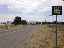
First reassurance sign along northbound SR 895
SR 895 starts at the eastern side of Preston, and turns northwestward. As the route leaves Preston, it turns northward. The road heads across the desert for about a mile, then ends at SR 318 at a T-intersection.[3] SR 895 is not part of the National Highway System.[4]
History
The short route was designated in 1976, and has not changed significantly since.[5][2]
Major intersections
The entire route is in White Pine County.
| Location | mi[1] | km | Destinations | Notes | |
|---|---|---|---|---|---|
| Preston | 0.000 | 0.000 | Preston | Continuation beyond terminus | |
| | 1.481 | 2.383 | |||
| 1.000 mi = 1.609 km; 1.000 km = 0.621 mi | |||||
See also
 Nevada portal
 U.S. Roads portal
References
| Wikimedia Commons has media related to Nevada State Route 895. |
- 1 2 Nevada Department of Transportation (2013). "Nevada State Maintained Highways: Descriptions, Index and Maps" (PDF). Retrieved 2013-12-15.
- 1 2 1976-77 Map of Nevada (PDF) (Map). Cartography by Nevada Department of Highways. Nevada Department of Highways. 1976. Retrieved 2013-12-15.
- ↑ Google (2013-12-15). "Nevada State Route 895" (Map). Google Maps. Google. Retrieved 2013-12-15.
- ↑ National Highway System: Nevada (PDF) (Map). Federal Highway Administration. March 2013. Retrieved 2013-12-15.
- ↑ 1975 Map of Nevada (PDF) (Map). Cartography by Nevada Department of Highways. Nevada Department of Highways. 1975. Retrieved 2013-12-15.
This article is issued from Wikipedia - version of the 9/9/2014. The text is available under the Creative Commons Attribution/Share Alike but additional terms may apply for the media files.