Kimsa Chata (Bolivia-Chile)
This article is about the mountains on the border of Bolivia and Chile. For other uses, see Kimsa Chata.
| Kimsa Chata | |
|---|---|
 The Kimsa Chata volcanic group | |
| Highest point | |
| Elevation | 6,052 m (19,856 ft) |
| Coordinates | 18°23′S 69°03′W / 18.383°S 69.050°WCoordinates: 18°23′S 69°03′W / 18.383°S 69.050°W |
| Geography | |
| Location | Chile |
| Parent range | Andes |
| Geology | |
| Mountain type | Stratovolcano |
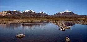
Kimsa Chata or Kimsachata (Aymara and Quechua kimsa three,[1] Pukina chata mountain,[2] "three mountains", hispanicized Quimsa Chata, Quimsachata) is a 8 km (5 mi)-long volcanic complex on a north-south alignment along the border between Bolivia and Chile, overseeing Chungara Lake. It contains three peaks, all stratovolcanoes.
The group is formed - from north to south - by Umurata (5,730 m (18,799 ft)), Acotango (6,052 m (19,856 ft)) and Capurata (5,990 m (19,652 ft)) (also known as Cerro Elena Capurata). The active volcano Guallatiri (Wallatiri) west of Capurata is not part of the group.
See also
Sources
- ↑ www.katari.org Aymara-Spanish dictionary: Kimsa (adj.) - Número Tres.
- ↑ Teofilo Laime Ajacopa, Lengua Pukina en Jesús de Machaca, referring to Alfredo Torero ("Reflexión acerca del pukina escrito por Alfredo Torero ... Pukina <Chata> - Castellano Cerro - Palabras relacionadas en aymara Qullu") (English: mountain). ... Existencia de palabras pukinas en Jesús de Machaca: Qullunaka (cerros): Kimsa Chata
- Siebert L, Simkin T (2002-). Volcanoes of the World: an Illustrated Catalog of Holocene Volcanoes and their Eruptions. Smithsonian Institution, Global Volcanism Program Digital Information Series, GVP-3, (http://www.volcano.si.edu).
External links
Smithsonian Institution, volcanoes of Northern Chile, Bolivia and Argentina. http://www.volcano.si.edu/world/region.cfm?rnum=1505
This article is issued from Wikipedia - version of the 5/29/2016. The text is available under the Creative Commons Attribution/Share Alike but additional terms may apply for the media files.