New Cumberland Locks and Dam
| New Cumberland Lock and Dam | |
|---|---|
 | |
| Official name | New Cumberland Locks and Dam |
| Location | Ohio/West Virginia border |
| Coordinates | 40°31′41″N 80°37′33″W / 40.5281°N 80.6259°WCoordinates: 40°31′41″N 80°37′33″W / 40.5281°N 80.6259°W |
| Construction began | 1955 |
| Opening date | 1961 |
| Operator(s) |
|
| Dam and spillways | |
| Type of dam | Gated |
| Impounds | Ohio River |
| Reservoir | |
| Normal elevation | 664 feet above sealevel |
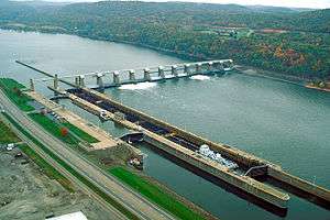
New Cumberland Lock and Dam is the fourth lock and dam on the Ohio River, located 54 miles downstream of Pittsburgh. There are two locks, one for commercial barge traffic that's 1,200 feet long by 110 feet wide, and the recreational auxiliary lock is 600 feet long by 110 feet wide. New Cumberland locks averages about 320 commercial lock throughs every month and 120 lock throughs a month on the recreational auxiliary lock.[1]
See also
References
External links
- U.S. Army Corps of Engineers, Pittsburgh District
- U.S. Army Corps of Engineers, Huntington District
- U.S. Army Corps of Engineers, Louisville District
This article is issued from Wikipedia - version of the 10/24/2016. The text is available under the Creative Commons Attribution/Share Alike but additional terms may apply for the media files.