New York State Route 378
| ||||
|---|---|---|---|---|
|
Map of Capital District in eastern New York with NY 378 highlighted in red | ||||
| Route information | ||||
| Maintained by NYSDOT | ||||
| Length: | 3.34 mi[1] (5.38 km) | |||
| Existed: | mid-1930s[2][3] – present | |||
| Major junctions | ||||
| West end: |
| |||
|
| ||||
| East end: |
| |||
| Location | ||||
| Counties: | Albany, Rensselaer | |||
| Highway system | ||||
| ||||

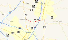
New York State Route 378 (NY 378) is a state highway in the Capital District of New York in the United States. It runs from Loudonville to Troy and traverses the Hudson River via the Menands Bridge. NY 378 once connected to Menands Road in the village of Menands; however, Menands Road has since been split in two by a now-closed exit ramp. NY 378 connects the western part of Menands Road with Troy. It also connects with NY 377 at Van Rensselaer Boulevard. NY 378 continues west of U.S. Route 9 (US 9) as Osborne Road (County Route 154). At its eastern terminus, NY 378 continues north as US 4. US 4 southbound is accessed by an eastward turn at the terminus.
Route description

NY 378 begins at an intersection with US 9 (Loudon Road) in the Loudonville section of Colonie as a continuation of County Route 154 (Osborne Road). NY 378 progresses southeast as Menand Road, a two-lane residential street through Colonie. The road expands to four lanes before intersecting with the northern terminus of NY 377 (Van Rennselaer Boulevard). After this intersection, NY 378 becomes a divided four-lane arterial, crossing eastbound through Colonie and into Menands. The route turns to the northeast, passing to the north of Ganser-Smith Memorial Park, crosses over a railroad line via a bridge, before entering into an interchange with NY 32 (Broadway). NY 378 becomes further divided into six lanes for a short distance after NY 32, entering interchange 7E and 7W of Interstate 787. NY 378 goes back to four lanes before crossing the Hudson River on the Menands Bridge, entering the city of Troy. Crossing over another railroad line on the other shore, NY 378 becomes known as High Street before curving northbound and terminating at an intersection with US 4 (Mill Street / Burden Avenue) in Troy.[4]
History
NY 378 was assigned in the mid-1930s to Menands Road, a short connector road between US 9 in Loudonville and NY 32 in Menands. The Troy–Menands Bridge linking Menands to Troy was initially unnumbered.[2][3] In the early 1940s, NY 2 was extended south from Troy to downtown Albany by way of the bridge.[5][6] NY 378 was realigned east of NY 377 in the early 1950s to follow a new highway connecting directly to the Troy–Menands Bridge.[7][8] On January 1, 1970, NY 2 was truncated to Troy on its western end. Its former routing across the Hudson River to US 4 in southern Troy became an extension of NY 378.[9]
Major intersections
| County | Location | mi[1] | km | Destinations | Notes |
|---|---|---|---|---|---|
| Albany | Town of Colonie | 0.00 | 0.00 | Hamlet of Loudonville | |
| Menands | 0.93 | 1.50 | South entrance to Albany Rural Cemetery | ||
| 1.94 | 3.12 | Parclo interchange | |||
| 2.53 | 4.07 | Exit 7 (I-787) | |||
| Rensselaer | Troy | 3.34 | 5.38 | ||
| 1.000 mi = 1.609 km; 1.000 km = 0.621 mi | |||||
See also
.svg.png) New York Roads portal
New York Roads portal
References
- 1 2 "2008 Traffic Volume Report for New York State" (PDF). New York State Department of Transportation. June 16, 2009. p. 223. Retrieved February 1, 2010.
- 1 2 Road Map of New York (Map). Cartography by Rand McNally and Company. Texas Oil Company. 1934.
- 1 2 New York (Map). Cartography by General Drafting. Standard Oil Company. 1937.
- ↑ Microsoft; Nokia (April 13, 2012). "Overview map of NY 378" (Map). Bing Maps. Microsoft. Retrieved April 13, 2012.
- ↑ New York (Map). Cartography by General Drafting. Esso. 1940.
- ↑ New York with Pictorial Guide (Map). Cartography by General Drafting. Esso. 1942.
- ↑ New York (Map). Cartography by Rand McNally and Company. Sunoco. 1952.
- ↑ New York with Special Maps of Putnam–Rockland–Westchester Counties and Finger Lakes Region (Map) (1955–56 ed.). Cartography by General Drafting. Esso. 1954.
- ↑ State of New York Department of Transportation (January 1, 1970). Official Description of Touring Routes in New York State (PDF). Retrieved May 24, 2009.
External links
- New York State Route 378 at Alps' Roads • New York Routes • New York State Highway Termini