New York State Route 438
| ||||
|---|---|---|---|---|
|
Map of western New York with NY 438 highlighted in red | ||||
| Route information | ||||
| Maintained by Erie County, the Cattaraugus Reservation, the town of Collins, and the village of Gowanda | ||||
| Length: | 11.78 mi[1] (18.96 km) | |||
| Existed: | mid-1940s[2][3] – present | |||
| Major junctions | ||||
| South end: |
| |||
| North end: |
| |||
| Location | ||||
| Counties: | Erie | |||
| Highway system | ||||
| ||||

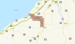
New York State Route 438 (NY 438) is a north–south state highway located entirely in Erie County, New York, in the United States. Though signed as north–south, the route runs in an almost east–west direction for 11.78 miles (18.96 km) between Gowanda and Irving through the Cattaraugus Indian Reservation. The southern terminus of the route is at an intersection with U.S. Route 62 (US 62) and NY 39 in Gowanda. Its northern terminus is at a junction with US 20 and NY 5 in Irving. The route was assigned in the mid-1940s. Although it is signed as a state route, the state does not maintain any of the route.
Route description

NY 438 begins at an intersection with US 62 and NY 39 in northern Gowanda. The route heads north, inheriting the Buffalo Street moniker from US 62 and NY 39, which turn east at NY 438's southern terminus. Outside of the village in Collins, the route becomes Four Mile Level Road as it curves westward into the Cattaraugus Indian Reservation.[4] As its name implies, the route traverses relatively level terrain for a stretch of roughly 4 miles (6 km) as it parallels the northern bank of Cattaraugus Creek to the northwest and west.[5][6] During this stretch, NY 438 intersects both Versailles–Plank Road and Brant Road (southern terminus of County Route 9 or CR 9) and crosses over the narrow Clear Creek.[4]
As it approaches Irving, NY 438 becomes Irving–Gowanda Road, named for the communities at each terminus. The route heads northwest across undeveloped but level terrain, crossing over the New York State Thruway (Interstate 90) without connecting to the highway. NY 438 comes to an end shortly afterward at a junction with US 20 and NY 5 northeast of Irving in the town of Brant. Access to the Thruway is made via exit 58, located a mile (1.6 km) to the southwest on US 20 and NY 5 in Irving, a hamlet in the adjacent Chautauqua County town of Hanover.[4]
Unlike most state routes, NY 438 is entirely locally maintained. The Seneca Nation of Indians, the tribe with jurisdiction over the Cattaraugus Reservation, maintains all of the road on the reservation (which is all of the road except the southernmost 0.75 miles (1.21 km), which lies outside the reservation bounds). From the reservation line southward, maintenance of the short stretch of road is divided among three municipalities: Erie County maintains 0.32 miles (0.51 km), followed by 0.27 miles (0.43 km) of road maintained by the town of Collins. The southernmost 0.16 miles (0.26 km) of the route is within the village of Gowanda and is maintained by the village.[7]
History
NY 438 was assigned to the entirety of its current alignment in the mid-1940s.[2][3] The bridge carrying NY 438 over the New York State Thruway, 61.5 meters (201.8 ft) in length, was constructed in 1958.[8] Farther east, the 39-meter (128 ft) bridge over Clear Creek was originally built in 1935 and reconstructed in 1992.[9]
Major intersections
The entire route is in Erie County.
| Location | mi[1] | km | Destinations | Notes | |
|---|---|---|---|---|---|
| Gowanda | 0.00 | 0.00 | |||
| Brant | 11.78 | 18.96 | |||
| 1.000 mi = 1.609 km; 1.000 km = 0.621 mi | |||||
See also
.svg.png) New York Roads portal
New York Roads portal
References
- 1 2 "2008 Traffic Data Report for New York State" (PDF). New York State Department of Transportation. June 16, 2009. p. 315. Retrieved January 10, 2010.
- 1 2 New York with Pictorial Guide (Map). Cartography by General Drafting. Esso. 1942.
- 1 2 Official Highway Map of New York State (Map) (1947–48 ed.). Cartography by General Drafting. State of New York Department of Public Works.
- 1 2 3 Google (March 24, 2008). "overview map of NY 438" (Map). Google Maps. Google. Retrieved March 24, 2008.
- ↑ Farnham Quadrangle – New York (Map). 1:24,000. 7.5 Minute Series (Topographic). United States Geological Survey. 1960. Retrieved December 16, 2010.
- ↑ North Collins Quadrangle – New York (Map). 1:24,000. 7.5 Minute Series (Topographic). United States Geological Survey. 1960. Retrieved December 16, 2010.
- ↑ "Erie County Inventory Listing" (CSV). New York State Department of Transportation. March 2, 2010. Retrieved December 16, 2010.
- ↑ Federal Highway Administration (2012). "NBI Structure Number: 6048500". National Bridge Inventory. Federal Highway Administration.
- ↑ Federal Highway Administration (2012). "NBI Structure Number: 6060710". National Bridge Inventory. Federal Highway Administration.
External links
| Wikimedia Commons has media related to New York State Route 438. |
- New York State Route 438 at New York Routes • New York State Highway Termini