Newport Arch
| Newport Arch | |
|---|---|
|
Newport Arch from the south | |
 Newport Arch  Newport Arch Newport Arch shown within Lincoln / Lincolnshire | |
| General information | |
| Type | Gateway to Roman Fort |
| Town or city | Lincoln |
| Country | England |
| Coordinates | 53°14′15″N 0°32′18″W / 53.237411°N 0.538353°WCoordinates: 53°14′15″N 0°32′18″W / 53.237411°N 0.538353°W |
| Estimated completion | 3rd century |
| Reference no. | 1005478 |
Listed Building – Grade I | |
| Designated | 8 October 1953 |
| Reference no. | 1388450 |
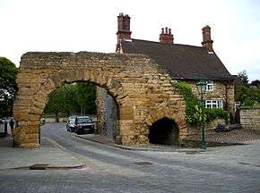
Newport Arch is the name given to the remains of a 3rd-century Roman gate in the city of Lincoln, Lincolnshire.[1] It is a Scheduled monument[2] and Grade I listed building[3] and is reputedly the oldest arch in the United Kingdom still used by traffic.
History

The arch was remodelled and enlarged when the city, then Lindum Colonia a Roman town, became capital of the province Flavia Caesariensis in the 4th century. Though unique in the United Kingdom, it is nevertheless one of many original Roman arches still open to traffic, other examples being two gates through the city walls of the Roman town of Diocletianopolis (now Hisarya, Bulgaria), as well as numerous examples in Turkey.
As the north gate of the city, it carried the major Roman road Ermine Street northward almost in a straight line to the Humber.
From Romano-British Buildings and Earthworks by John Ward (1911):
- "A considerable portion of the north gate of Lincoln — the Newport Arch — is standing, but is buried to the extent of about 8 ft (2.4 m). in the soil and débris accumulated since Roman times. The structure is about 34 ft (10 m). deep and has a single passage for the road, 17½ ft. wide. The inner or back portal of this passage is still intact, and is nearly 16 ft (4.9 m). in the clear and rises to a height of about 22½ ft. above the Roman level. Its arch is of a single ring of large limestone voussoirs rising from imposts which appear to have been moulded. The outer or front arch has long since disappeared. On the east side is a postern for pedestrians, 7 ft (2.1 m). wide and contracting to about 5 ft (1.5 m). at the north end, and 15 ft (4.6 m). high from the Roman level. On the west side there was a similar postern about a century ago. The whole structure is of good masonry, and it appears to have projected considerably beyond the north face of the town wall."
Accidents
In May 1964 a goods lorry belonging to the Humber Warehousing Co struck the arch while attempting to pass under it.[4]
Forty years later, in May 2004, another lorry struck the arch, causing minor damage.[5]
References
- ↑ Historic England. "Newport Arch (1029539)". PastScape. Retrieved 13 September 2009.
- ↑ Historic England. "The Newport Arch and town wall (1005478)". National Heritage List for England. Retrieved 30 June 2016.
- ↑ Historic England. "No 52 and adjoining Newport Arch (1388450)". National Heritage List for England. Retrieved 30 June 2016.
- ↑ "A lorry full of trouble". Grimsby Telegraph. 11 October 2014. Retrieved 30 June 2016.
- ↑ "Historic Roman arch hit by lorry". BBC News. 26 May 2004. Retrieved 7 May 2015.
- Ionescu, Daniel (8 May 2013). "Repair works set for Newport Arch in Bailgate". The Lincolnite. Retrieved 1 August 2013.
External links
| Wikimedia Commons has media related to Newport Arch. |
- Lindum: General information on Roman Lincoln and inscriptions
- Not resting on their laurels A survey of Lincoln's Roman heritage