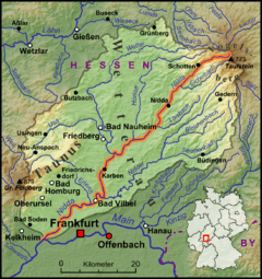
Nidda (river)
| Nidda | |
|---|---|
 Map of the Nidda river. | |
| Country | Germany |
| Basin | |
| Main source |
Vogelsberg 720 m (2,360 ft) |
| River mouth |
Main 50°5′58″N 8°33′5″E / 50.09944°N 8.55139°ECoordinates: 50°5′58″N 8°33′5″E / 50.09944°N 8.55139°E |
| Basin size | 1,619.3 km2 (625.2 sq mi) |
| Physical characteristics | |
| Length | 98 km (61 mi) |
The Nidda is a right tributary of the Main river in Hesse.
It springs from the Vogelsberg on the Taufstein mountain range near the town of Schotten, flows through the Niddastausee dam, and the towns of Nidda, Niddatal, Karben, and Bad Vilbel. At Harheim it reaches the Frankfurt am Main city area and after 98 km enters the Main in Frankfurt's Höchst quarter.
In the 1920s and 1960s, the flow of the Nidda was regulated to reduce the risk of floods. The original numerous meanders turned into bayous, while the riverbed was straightened and made deeper. Since 1993 the Nidda has been partially restored to its natural state and a bicycle path built along the river.
The tributaries on the left are the Eichelbach and the Nidder and on the right the Horloff, Wetter, Erlenbach, Eschbach, Kalbach, Urselbach, Steinbach, and Sulzbach.
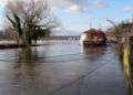 Nidda estuary „Wörthspitze“ with houseboats
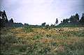 The area around the source of the Nidda
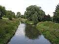 Mouth of the tributary Nidder
External links
![]() Media related to Nidda (Main) at Wikimedia Commons
Media related to Nidda (Main) at Wikimedia Commons