Nijgadh
| Nijgadh Municipality निजगढ नगरपालिका | |
|---|---|
| Municipality | |
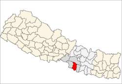
 Nijgadh Municipality Location in Nepal | |
| Coordinates: 27°12′N 85°08′E / 27.20°N 85.14°ECoordinates: 27°12′N 85°08′E / 27.20°N 85.14°E | |
| Country |
|
| Region (विकास क्षेत्र) | Central Development Region (मध्यमाञ्चल विकास क्षेत्र) |
| Zone (अञ्चल) | Narayani Zone (नारायणी अञ्चल) |
| District (जिल्ला) | Bara District (बारा जिल्ला) |
| Population (2011) | |
| • Total | 19,614 |
| Time zone | NST (UTC+5:45) |
| Website |
Nijgadh.comnijgadhnews |
Nijgadh (Nepali: निजगढ) is a town and municipality in Bara District in the Narayani Zone of south-eastern Nepal. The existing Nijgadh village was merged with the existing Ratnapuri VDC and Bharatganj Singaul VDC in May 2014.[1] [2] [3]
At the time of the 2011 Nepal Census, Nijgadh had a population of 19,614 persons (9,525 male and 10,089 female) living in 3,982 individual households.[4]
The town has been targeted as a site for an international airport that could handle 15 million passengers and even accommodate the super-jumbo Airbus A380 after the first phase of construction. As of April 2011, a feasibility study of the report was completed. The report stated that the airport would cover 3,000 hectares of land: 2,000 hectares for airport and the remaining 1,000 for the airport city.[5]
References
- ↑ [निजगढको परिचय (Short Description About Nijgadh)] Archived index at the Wayback Machine. Nijgadh News
- ↑ 72 new municipalities announced Archived June 18, 2014, at the Wayback Machine. My Republica
- ↑ Govt announces 72 new municipalities The Kathmandu Post
- ↑ "Nepal Census 2001". Nepal's Village Development Committees. Digital Himalaya. Archived from the original on October 12, 2008. Retrieved 21 September 2008.
- ↑ "Read online latest news and articles from Nepal.". Retrieved 26 November 2016.
External links
- About Nijgadh
- Nijgadh on Facebook
- UN map of the municipalities of Bara District
- निजगढको परिचय (Short Description About Nijgadh) - Nijgadh News
- Nijgadh on Facebook
